- 非洲
- 阿尔巴尼亚语
- 阿姆哈拉语
- 阿拉伯
- 亚美尼亚语
- 阿塞拜疆语
- 巴斯克
- 白俄罗斯语
- 孟加拉
- 波斯尼亚语
- 保加利亚语
- 加泰罗尼亚语
- 宿务语
- 中国
- 科西嘉
- 克罗地亚语
- 捷克语
- 丹麦语
- 荷兰语
- 英语
- 世界语
- 爱沙尼亚语
- 芬兰
- 法语
- 弗里斯兰语
- 加利西亚语
- 格鲁吉亚
- 德语
- 希腊语
- 古吉拉特语
- 海地克里奥尔语
- 豪萨语
- 夏威夷
- 希伯来语
- 不
- 苗族
- 匈牙利
- 冰岛语
- 伊博语
- 印度尼西亚
- 爱尔兰
- 意大利语
- 日本人
- 爪哇语
- 卡纳达语
- 哈萨克语
- 高棉语
- 卢旺达
- 韩国人
- 库尔德
- 吉尔吉斯
- 劳动
- 拉丁
- 拉脱维亚语
- 立陶宛语
- 卢森堡语
- 马其顿语
- 马尔加什
- 马来语
- 马拉雅拉姆语
- 马耳他语
- 毛利人
- 马拉地语
- 蒙
- 缅甸
- 尼泊尔语
- 挪威
- 挪威
- 奥克西唐语
- 普什图语
- 波斯语
- 抛光
- 葡萄牙语
- 旁遮普语
- 罗马尼亚语
- 俄语
- 萨摩亚
- 苏格兰盖尔语
- 塞尔维亚
- 英语
- 绍纳语
- 信德语
- 僧伽罗语
- 斯洛伐克语
- 斯洛文尼亚语
- 索马里
- 西班牙语
- 巽他語
- 斯瓦希里语
- 瑞典
- 他加禄语
- 塔吉克
- 泰米尔语
- 鞑靼语
- 泰卢固语
- 泰国
- 土耳其
- 土库曼人
- 乌克兰
- 乌尔都语
- 维吾尔
- 乌兹别克语
- 越南语
- 威尔士语
- 帮助
- 意第绪语
- 约鲁巴人
- 祖鲁语
范围
|
Digital twin river basin standardized data base plate |
Water regulation |
|
DOM Data Backboard |
Establishment, revision and updating of reservoir capacity curve |
|
DEM/DSM Data Baseboard |
Irrigation area monitoring and water consumption calculation by remote sensing |
|
Flood and drought disaster monitoring services |
范围
|
River basin flood control project construction monitoring |
River and lake supervision (river and lake chief system management) |
|
Situation of Reservoir construction |
River and lake sand mining planning |
|
Safety of dam and reservoir bank |
River and lake remote sensing feature interpretation |
|
The construction of flood storage area |
Investigation of prominent problems hindering river flood flow |
|
River channels and beware of construction |
Planning for the protection of key river banks and shorelines |
|
|
"Normalize and standardize" the four disordered areas in Qing Dynasty |
|
|
The boundary data of shoreline spatial control of river and lake management waters are dynamically updated |
范围
|
Soil and water conservation supervision |
Supervision of water environment and water ecology |
|
Soil and Water Conservation |
Bloom monitoring |
|
Disturbance supervision |
Outfall monitoring |
|
Cage fish culture |
|
Marine regulation |
|
|
Coastlines, reefs and beaches monitoring |
|
|
Fishery resources Monitoring |
|
|
Enteromorpha and red tide monitoring |
|
|
Marine Disaster Warning
|
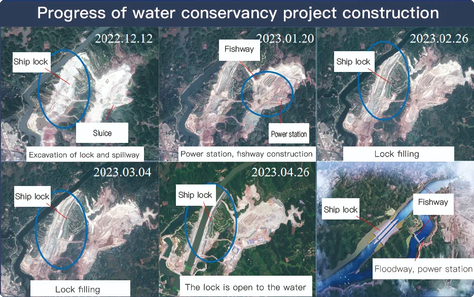
Application Of Monitoring The Construction Of Water Conservancy Facilities
For the full coverage of remote sensing data of Jilin-1 satellite and high revisit ability, it can timely monitor the construction of water conservancy facilities, dam and reservoir bank safety, flood storage area construction, river and guard construction, etc., assist the water conservancy department in the construction and management of water conservancy projects, improve the construction quality of water conservancy projects, and comprehensively understand the progress of the project.
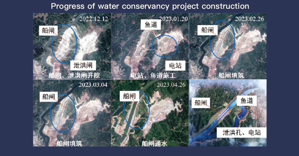
吉林一号卫星系统以遥感数据全面覆盖和高重访能力而闻名,在水利设施的监测和管理中发挥着至关重要的作用。其先进的成像技术可以对水坝、水库、灌溉系统和河堤等基础设施进行高分辨率实时观测,为施工进度跟踪、结构完整性评估和早期风险检测提供重要数据。
吉林一号具备高频重访能力,可以持续捕捉和更新目标位置的图像,确保及时发现水位变化、土壤稳定性和潜在的结构弱点。这种能力对于灾害预防尤其有价值,因为它使当局能够在山体滑坡、水坝侵蚀和洪水威胁等风险升级之前识别它们。
Moreover, the satellite’s multi-spectral and high-resolution imaging enhances the ability to monitor environmental conditions around water conservancy projects, such as vegetation cover, sedimentation, and water pollution levels. This data supports decision-making for sustainable water resource management and climate adaptation strategies.
By integrating Jilin-1 remote sensing data with geographic information systems (GIS) and artificial intelligence, real-time monitoring and predictive analysis can be further enhanced, improving response efficiency and safety measures. The satellite’s capability to provide accurate and timely data reduces reliance on ground inspections, lowering operational costs and improving the overall resilience of water conservancy infrastructure. Thus, Jilin-1 serves as a powerful tool for governments, environmental agencies, and engineering firms to ensure the safety and efficiency of water-related projects.
