- Afriken
- Albanè
- Amarik
- Arab
- Amenyen
- Azerbaydjan
- Basque
- Belarisyen
- Bengali
- Bosnyen
- Bulgarian
- Catalan
- Cebuano
- Lachin
- Kors
- Kwoasyen
- Czech
- Danwa
- Olandè
- angle
- Esperanto
- Estonyen
- Finnish
- franse
- Frisyen
- Galisyen
- Jòjyen
- Alman
- grèk
- Gujarati
- Kreyòl ayisyen
- Hausa
- Hawaiian
- ebre
- Non
- Miao
- Ongwa
- Icelandic
- igbo
- Endonezyen
- Ilandè
- Italyen
- Japonè
- Javanèz
- Kannada
- kazak
- Khmer
- Rwandan
- Koreyen
- Kurdish
- Kyrgyz
- Travay
- Latin
- Latvian
- Lityanyen
- Luxembourgish
- Masedwan
- Malagasy
- Malay
- Malayalam
- Maltese
- Maori
- Marathi
- Mongolyen
- Myanma
- Nepali
- Nòvejyen
- Nòvejyen
- Occitan
- Pashto
- Pèsik
- Polonè
- Pòtigè
- Punjabi
- Woumen
- Ris
- Samoan
- Scottish Gaelic
- Sèb
- angle
- Shona
- Sindhi
- Sinhala
- Slovak
- Sloveni
- Somalyen
- Panyòl
- Sundanese
- Swahili
- Swedish
- Tagalog
- Tajik
- Tamil
- Tatar
- Telugu
- Thai
- Tik
- Tirkmen
- Ukrainian
- Oudou
- Ouygur
- Ouzbek
- Vyetnamyen
- Welsh
- Ede
- Yiddish
- Yoruba
- Zoulou
Pwodwi ak sèvis pou konsève dlo
paramèt
|
Digital twin river basin standardized data base plate |
Water regulation |
|
DOM Data Backboard |
Establishment, revision and updating of reservoir capacity curve |
|
DEM/DSM Data Baseboard |
Irrigation area monitoring and water consumption calculation by remote sensing |
|
Flood and drought disaster monitoring services |
paramèt
|
River basin flood control project construction monitoring |
River and lake supervision (river and lake chief system management) |
|
Situation of Reservoir construction |
River and lake sand mining planning |
|
Safety of dam and reservoir bank |
River and lake remote sensing feature interpretation |
|
The construction of flood storage area |
Investigation of prominent problems hindering river flood flow |
|
River channels and beware of construction |
Planning for the protection of key river banks and shorelines |
|
|
"Normalize and standardize" the four disordered areas in Qing Dynasty |
|
|
The boundary data of shoreline spatial control of river and lake management waters are dynamically updated |
paramèt
|
Soil and water conservation supervision |
Supervision of water environment and water ecology |
|
Soil and Water Conservation |
Bloom monitoring |
|
Disturbance supervision |
Outfall monitoring |
|
Cage fish culture |
|
Marine regulation |
|
|
Coastlines, reefs and beaches monitoring |
|
|
Fishery resources Monitoring |
|
|
Enteromorpha and red tide monitoring |
|
|
Marine Disaster Warning
|
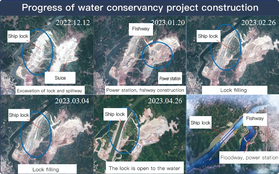
Application Of Monitoring The Construction Of Water Conservancy Facilities
For the full coverage of remote sensing data of Jilin-1 satellite and high revisit ability, it can timely monitor the construction of water conservancy facilities, dam and reservoir bank safety, flood storage area construction, river and guard construction, etc., assist the water conservancy department in the construction and management of water conservancy projects, improve the construction quality of water conservancy projects, and comprehensively understand the progress of the project.
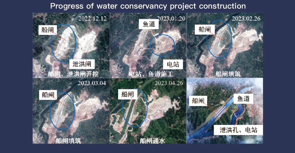
Sistèm satelit Jilin-1, li te ye pou pwoteksyon konplè li nan done deteksyon aleka ak gwo kapasite revize, jwe yon wòl enpòtan nan siveyans ak jesyon nan enstalasyon konsèvasyon dlo. Teknoloji imaj avanse li pèmèt pou obsèvasyon an tan reyèl ak rezolisyon segondè nan enfrastrikti tankou baraj, rezèvwa, sistèm irigasyon, ak ke larivyè Lefrat, bay done esansyèl pou swiv pwogrè konstriksyon, evalyasyon entegrite estriktirèl, ak deteksyon risk bonè.
Avèk kapasite revizyon segondè-frekans li yo, Jilin-1 ka kontinyèlman pran ak mete ajou imaj nan kote sib yo, asire deteksyon alè nan chanjman nan nivo dlo, estabilite tè a, ak feblès potansyèl estriktirèl. Kapasite sa a patikilyèman enpòtan pou prevansyon dezas, paske li pèmèt otorite yo idantifye risk tankou glisman teren, ewozyon baraj, ak menas inondasyon anvan yo ogmante.
Moreover, the satellite’s multi-spectral and high-resolution imaging enhances the ability to monitor environmental conditions around water conservancy projects, such as vegetation cover, sedimentation, and water pollution levels. This data supports decision-making for sustainable water resource management and climate adaptation strategies.
By integrating Jilin-1 remote sensing data with geographic information systems (GIS) and artificial intelligence, real-time monitoring and predictive analysis can be further enhanced, improving response efficiency and safety measures. The satellite’s capability to provide accurate and timely data reduces reliance on ground inspections, lowering operational costs and improving the overall resilience of water conservancy infrastructure. Thus, Jilin-1 serves as a powerful tool for governments, environmental agencies, and engineering firms to ensure the safety and efficiency of water-related projects.
