- Châu Phi
- Tiếng Albania
- Tiếng Amharic
- Tiếng Ả Rập
- người Armenia
- Tiếng Azerbaijan
- Tiếng Basque
- người Belarus
- Tiếng Bengal
- người Bosnia
- Tiếng Bulgaria
- Tiếng Catalan
- Tiếng Cebuano
- Trung Quốc
- người Corsica
- Tiếng Croatia
- Tiếng Séc
- Tiếng Đan Mạch
- Tiếng Hà Lan
- Tiếng Anh
- Tiếng Esperanto
- Tiếng Estonia
- Phần Lan
- Tiếng Pháp
- Tiếng Frisia
- Tiếng Galicia
- người Gruzia
- Tiếng Đức
- Tiếng Hy Lạp
- Tiếng Gujarat
- Tiếng Creole Haiti
- Tiếng Hausa
- người Hawaii
- Tiếng Do Thái
- KHÔNG
- Miêu
- Tiếng Hungary
- Tiếng Iceland
- người Igbo
- Tiếng Indonesia
- người Ai-len
- Tiếng Ý
- Tiếng Nhật
- Tiếng Java
- Tiếng Kannada
- tiếng kazakh
- Tiếng Khmer
- người Rwanda
- Hàn Quốc
- người Kurd
- Tiếng Kyrgyzstan
- Lao
- Tiếng La-tinh
- Tiếng Latvia
- Tiếng Litva
- Tiếng Luxembourg
- Tiếng Macedonia
- Tiếng Malagasy
- Tiếng Mã Lai
- Tiếng Mã Lai
- Tiếng Malta
- Người Maori
- Tiếng Marathi
- Mông Cổ
- Miến Điện
- Tiếng Nepal
- Tiếng Na Uy
- Tiếng Na Uy
- Tiếng Occitan
- Tiếng Pashto
- Tiếng Ba Tư
- Đánh bóng
- Tiếng Bồ Đào Nha
- Tiếng Punjab
- Tiếng Rumani
- Tiếng Nga
- Người Samoa
- Tiếng Gaelic Scotland
- Tiếng Serbia
- Tiếng Anh
- Shona
- Tiếng Sindhi
- Tiếng Sinhala
- Tiếng Slovak
- Tiếng Slovenia
- Tiếng Somali
- Tiếng Tây Ban Nha
- Tiếng Sunda
- Tiếng Swahili
- Tiếng Thụy Điển
- Tiếng Tagalog
- Tiếng Tajik
- Tiếng Tamil
- Người Tatar
- Tiếng Telugu
- Thái Lan
- Thổ Nhĩ Kỳ
- Người Turkmen
- Tiếng Ukraina
- Tiếng Urdu
- Người Duy Ngô Nhĩ
- Tiếng Uzbek
- Tiếng Việt
- Tiếng Wales
- Giúp đỡ
- Tiếng Yiddish
- Tiếng Yoruba
- Tiếng Zulu
Sản phẩm và dịch vụ bảo tồn nước
tham số
|
Digital twin river basin standardized data base plate |
Water regulation |
|
DOM Data Backboard |
Establishment, revision and updating of reservoir capacity curve |
|
DEM/DSM Data Baseboard |
Irrigation area monitoring and water consumption calculation by remote sensing |
|
Flood and drought disaster monitoring services |
tham số
|
River basin flood control project construction monitoring |
River and lake supervision (river and lake chief system management) |
|
Situation of Reservoir construction |
River and lake sand mining planning |
|
Safety of dam and reservoir bank |
River and lake remote sensing feature interpretation |
|
The construction of flood storage area |
Investigation of prominent problems hindering river flood flow |
|
River channels and beware of construction |
Planning for the protection of key river banks and shorelines |
|
|
"Normalize and standardize" the four disordered areas in Qing Dynasty |
|
|
The boundary data of shoreline spatial control of river and lake management waters are dynamically updated |
tham số
|
Soil and water conservation supervision |
Supervision of water environment and water ecology |
|
Soil and Water Conservation |
Bloom monitoring |
|
Disturbance supervision |
Outfall monitoring |
|
Cage fish culture |
|
Marine regulation |
|
|
Coastlines, reefs and beaches monitoring |
|
|
Fishery resources Monitoring |
|
|
Enteromorpha and red tide monitoring |
|
|
Marine Disaster Warning
|
Application Of Monitoring The Construction Of Water Conservancy Facilities
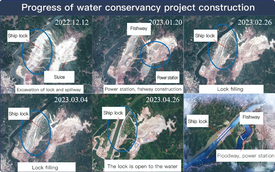
For the full coverage of remote sensing data of Jilin-1 satellite and high revisit ability, it can timely monitor the construction of water conservancy facilities, dam and reservoir bank safety, flood storage area construction, river and guard construction, etc., assist the water conservancy department in the construction and management of water conservancy projects, improve the construction quality of water conservancy projects, and comprehensively understand the progress of the project.
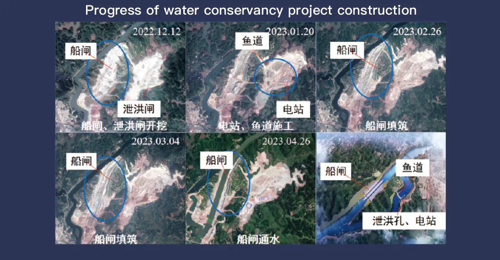
Hệ thống vệ tinh Jilin-1, được biết đến với phạm vi bao phủ toàn bộ dữ liệu cảm biến từ xa và khả năng tái hiện cao, đóng vai trò quan trọng trong việc giám sát và quản lý các cơ sở bảo tồn nước. Công nghệ hình ảnh tiên tiến của hệ thống cho phép quan sát cơ sở hạ tầng như đập, hồ chứa, hệ thống thủy lợi và bờ sông với độ phân giải cao, thời gian thực, cung cấp dữ liệu thiết yếu để theo dõi tiến độ xây dựng, đánh giá tính toàn vẹn của kết cấu và phát hiện rủi ro sớm.
Với khả năng xem lại tần suất cao, Jilin-1 có thể liên tục chụp và cập nhật hình ảnh các vị trí mục tiêu, đảm bảo phát hiện kịp thời những thay đổi về mực nước, độ ổn định của đất và các điểm yếu tiềm ẩn về cấu trúc. Khả năng này đặc biệt có giá trị đối với công tác phòng chống thiên tai, vì nó cho phép các cơ quan chức năng xác định các rủi ro như lở đất, xói mòn đập và nguy cơ lũ lụt trước khi chúng leo thang.
Moreover, the satellite’s multi-spectral and high-resolution imaging enhances the ability to monitor environmental conditions around water conservancy projects, such as vegetation cover, sedimentation, and water pollution levels. This data supports decision-making for sustainable water resource management and climate adaptation strategies.
By integrating Jilin-1 remote sensing data with geographic information systems (GIS) and artificial intelligence, real-time monitoring and predictive analysis can be further enhanced, improving response efficiency and safety measures. The satellite’s capability to provide accurate and timely data reduces reliance on ground inspections, lowering operational costs and improving the overall resilience of water conservancy infrastructure. Thus, Jilin-1 serves as a powerful tool for governments, environmental agencies, and engineering firms to ensure the safety and efficiency of water-related projects.
