- افریقی
- البانوی
- امہاری
- عربی
- آرمینیائی
- آذربائیجانی
- باسکی
- بیلاروسی
- بنگالی
- بوسنیائی
- بلغاریائی
- کاتالان
- سیبوانو
- چین
- کورسیکن
- کروشین
- چیک
- ڈینش
- ڈچ
- انگریزی
- ایسپرانٹو
- اسٹونین
- فنش
- فرانسیسی
- فریسیئن
- گالیشین
- جارجیائی
- جرمن
- یونانی
- گجراتی
- ہیٹی کریول
- ہاؤسا
- ہوائی
- عبرانی
- نہیں
- میاؤ
- ہنگری
- آئس لینڈی
- igbo
- انڈونیشین
- آئرش
- اطالوی
- جاپانی
- جاوانی
- کنڑ
- قازق
- خمیر
- روانڈا
- کورین
- کرد
- کرغیز
- مزدوری
- لاطینی
- لیٹوین
- لتھوینیائی
- لکسمبرگش
- مقدونیائی
- ملاگاسی
- مالائی
- ملیالم
- مالٹیز
- ماوری
- مراٹھی
- منگول
- میانمار
- نیپالی
- ناروے
- ناروے
- آکسیٹن
- پشتو
- فارسی
- پولش
- پرتگالی
- پنجابی
- رومانیہ
- روسی
- سامون
- سکاٹش گیلک
- سربیائی
- انگریزی
- شونا
- سندھی
- سنہالا
- سلوواک
- سلووینیائی
- صومالی
- ہسپانوی
- سنڈانی
- سواحلی
- سویڈش
- ٹیگالوگ
- تاجک
- تامل
- تاتار
- تیلگو
- تھائی
- ترکی
- ترکمان
- یوکرینی
- اردو
- ایغور
- ازبک
- ویتنامی
- ویلش
- مدد
- یدش
- یوروبا
- زولو
پانی کے تحفظ کی مصنوعات اور خدمات
پیرامیٹر
|
Digital twin river basin standardized data base plate |
Water regulation |
|
DOM Data Backboard |
Establishment, revision and updating of reservoir capacity curve |
|
DEM/DSM Data Baseboard |
Irrigation area monitoring and water consumption calculation by remote sensing |
|
Flood and drought disaster monitoring services |
پیرامیٹر
|
River basin flood control project construction monitoring |
River and lake supervision (river and lake chief system management) |
|
Situation of Reservoir construction |
River and lake sand mining planning |
|
Safety of dam and reservoir bank |
River and lake remote sensing feature interpretation |
|
The construction of flood storage area |
Investigation of prominent problems hindering river flood flow |
|
River channels and beware of construction |
Planning for the protection of key river banks and shorelines |
|
|
"Normalize and standardize" the four disordered areas in Qing Dynasty |
|
|
The boundary data of shoreline spatial control of river and lake management waters are dynamically updated |
پیرامیٹر
|
Soil and water conservation supervision |
Supervision of water environment and water ecology |
|
Soil and Water Conservation |
Bloom monitoring |
|
Disturbance supervision |
Outfall monitoring |
|
Cage fish culture |
|
Marine regulation |
|
|
Coastlines, reefs and beaches monitoring |
|
|
Fishery resources Monitoring |
|
|
Enteromorpha and red tide monitoring |
|
|
Marine Disaster Warning
|
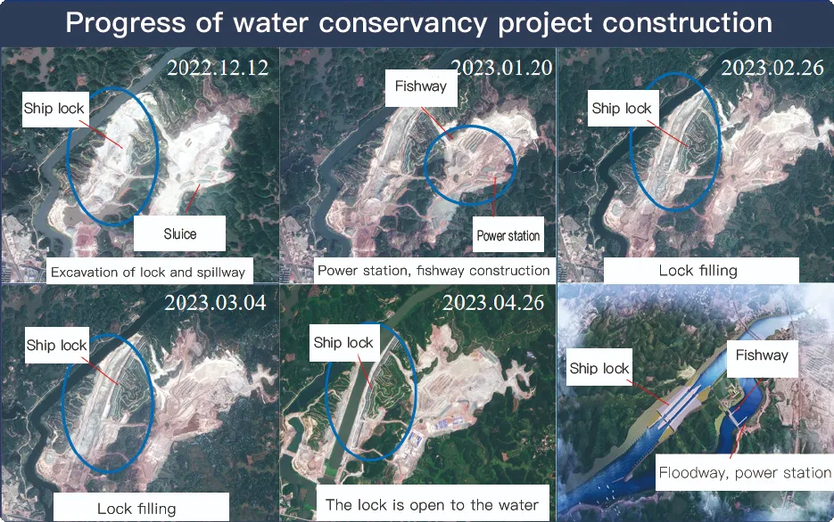
Application Of Monitoring The Construction Of Water Conservancy Facilities
For the full coverage of remote sensing data of Jilin-1 satellite and high revisit ability, it can timely monitor the construction of water conservancy facilities, dam and reservoir bank safety, flood storage area construction, river and guard construction, etc., assist the water conservancy department in the construction and management of water conservancy projects, improve the construction quality of water conservancy projects, and comprehensively understand the progress of the project.
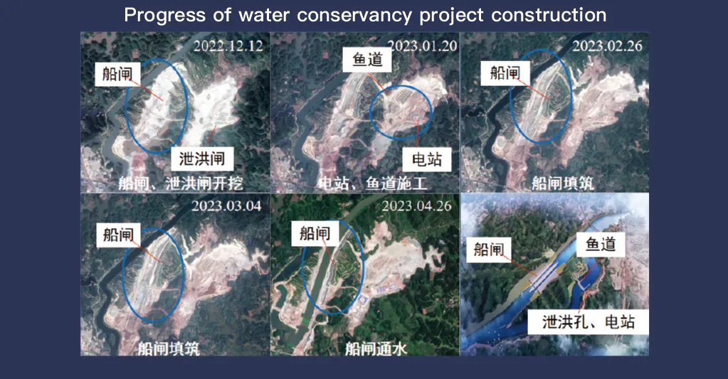
Jilin-1 سیٹلائٹ سسٹم، جو کہ ریموٹ سینسنگ ڈیٹا کی مکمل کوریج اور اعلیٰ دوبارہ دیکھنے کی صلاحیت کے لیے جانا جاتا ہے، پانی کے تحفظ کی سہولیات کی نگرانی اور انتظام میں اہم کردار ادا کرتا ہے۔ اس کی جدید ترین امیجنگ ٹیکنالوجی ہائی ریزولوشن، بنیادی ڈھانچے جیسے ڈیموں، ذخائر، آبپاشی کے نظام، اور دریا کے پشتوں کے حقیقی وقت کے مشاہدے کی اجازت دیتی ہے، تعمیراتی پیشرفت سے باخبر رہنے، ساختی سالمیت کی تشخیص، اور ابتدائی خطرے کا پتہ لگانے کے لیے ضروری ڈیٹا فراہم کرتی ہے۔
اپنی اعلی تعدد کے دوبارہ دیکھنے کی قابلیت کے ساتھ، Jilin-1 مسلسل ہدف کے مقامات کی تصاویر کھینچ کر اپ ڈیٹ کر سکتا ہے، پانی کی سطح میں تبدیلیوں، مٹی کے استحکام اور ممکنہ ساختی کمزوریوں کا بروقت پتہ لگانے کو یقینی بناتا ہے۔ یہ صلاحیت آفات سے بچاؤ کے لیے خاص طور پر قابل قدر ہے، کیونکہ یہ حکام کو اس قابل بناتی ہے کہ وہ خطرات جیسے کہ لینڈ سلائیڈنگ، ڈیم کٹاؤ، اور سیلاب کے خطرات بڑھنے سے پہلے ان کی شناخت کر سکیں۔
Moreover, the satellite’s multi-spectral and high-resolution imaging enhances the ability to monitor environmental conditions around water conservancy projects, such as vegetation cover, sedimentation, and water pollution levels. This data supports decision-making for sustainable water resource management and climate adaptation strategies.
By integrating Jilin-1 remote sensing data with geographic information systems (GIS) and artificial intelligence, real-time monitoring and predictive analysis can be further enhanced, improving response efficiency and safety measures. The satellite’s capability to provide accurate and timely data reduces reliance on ground inspections, lowering operational costs and improving the overall resilience of water conservancy infrastructure. Thus, Jilin-1 serves as a powerful tool for governments, environmental agencies, and engineering firms to ensure the safety and efficiency of water-related projects.
