- แอฟริกัน
- ชาวแอลเบเนีย
- อัมฮาริก
- ภาษาอาหรับ
- อาร์เมเนีย
- อาเซอร์ไบจาน
- บาสก์
- เบลารุส
- ภาษาเบงกาลี
- บอสเนีย
- ภาษาบัลแกเรีย
- คาตาลัน
- ชาวเซบู
- จีน
- คอร์ซิกา
- ภาษาโครเอเชียน
- เช็ก
- เดนมาร์ก
- ดัตช์
- ภาษาอังกฤษ
- เอสเปรันโต
- เอสโตเนีย
- ฟินแลนด์
- ภาษาฝรั่งเศส
- ฟรีเซียน
- กาลิเซียน
- จอร์เจีย
- เยอรมัน
- กรีก
- คุชราต
- ครีโอลเฮติ
- ฮาอูซา
- ฮาวาย
- ภาษาฮีบรู
- เลขที่
- เหมียว
- ฮังการี
- ไอซ์แลนด์
- ชาวอิโบ
- ชาวอินโดนีเซีย
- ไอริช
- อิตาลี
- ญี่ปุ่น
- ชวา
- ภาษากันนาดา
- คาซัค
- ภาษาเขมร
- รวันดา
- เกาหลี
- ชาวเคิร์ด
- คีร์กีซ
- แรงงาน
- ภาษาละติน
- ลัตเวีย
- ลิทัวเนีย
- ลักเซมเบิร์ก
- มาซิโดเนีย
- มาลากาซี
- มลายู
- มาลายาลัม
- มอลตา
- ชาวเมารี
- มาราฐี
- ชาวมองโกล
- พม่า
- เนปาล
- คนนอร์เวย์
- คนนอร์เวย์
- อ็อกซิตัน
- ปาทาน
- เปอร์เซีย
- ขัด
- โปรตุเกส
- ปัญจาบ
- โรมาเนีย
- รัสเซีย
- ชาวซามัว
- เกลิกสกอต
- เซอร์เบีย
- ภาษาอังกฤษ
- โชน่า
- สินธุ
- สิงหล
- สโลวัก
- ภาษาสโลวีเนีย
- โซมาลี
- สเปน
- ซุนดา
- ภาษาสวาฮีลี
- สวีเดน
- ภาษาตากาล็อก
- ทาจิก
- ทมิฬ
- ตาตาร์
- เตลูกู
- แบบไทย
- ภาษาตุรกี
- เติร์กเมน
- ยูเครน
- อูรดู
- ชาวอุยกูร์
- อุซเบก
- เวียดนาม
- ภาษาเวลส์
- ช่วย
- ยิดดิช
- ชาวโยรูบา
- ซูลู
ผลิตภัณฑ์และบริการเพื่อการอนุรักษ์น้ำ
พารามิเตอร์
|
Digital twin river basin standardized data base plate |
Water regulation |
|
DOM Data Backboard |
Establishment, revision and updating of reservoir capacity curve |
|
DEM/DSM Data Baseboard |
Irrigation area monitoring and water consumption calculation by remote sensing |
|
Flood and drought disaster monitoring services |
พารามิเตอร์
|
River basin flood control project construction monitoring |
River and lake supervision (river and lake chief system management) |
|
Situation of Reservoir construction |
River and lake sand mining planning |
|
Safety of dam and reservoir bank |
River and lake remote sensing feature interpretation |
|
The construction of flood storage area |
Investigation of prominent problems hindering river flood flow |
|
River channels and beware of construction |
Planning for the protection of key river banks and shorelines |
|
|
"Normalize and standardize" the four disordered areas in Qing Dynasty |
|
|
The boundary data of shoreline spatial control of river and lake management waters are dynamically updated |
พารามิเตอร์
|
Soil and water conservation supervision |
Supervision of water environment and water ecology |
|
Soil and Water Conservation |
Bloom monitoring |
|
Disturbance supervision |
Outfall monitoring |
|
Cage fish culture |
|
Marine regulation |
|
|
Coastlines, reefs and beaches monitoring |
|
|
Fishery resources Monitoring |
|
|
Enteromorpha and red tide monitoring |
|
|
Marine Disaster Warning
|
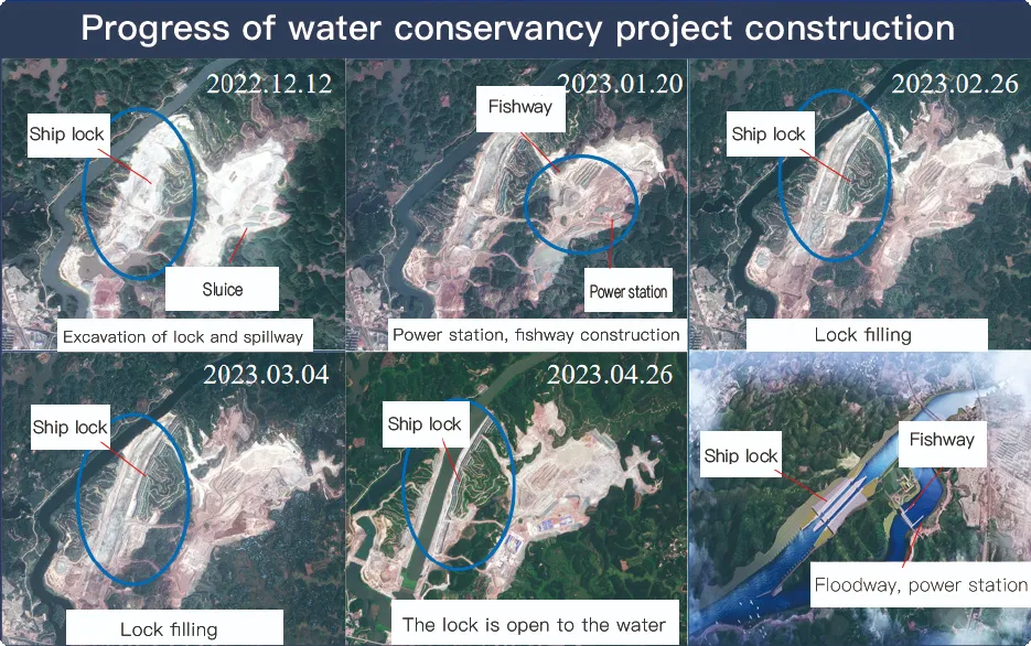
Application Of Monitoring The Construction Of Water Conservancy Facilities
For the full coverage of remote sensing data of Jilin-1 satellite and high revisit ability, it can timely monitor the construction of water conservancy facilities, dam and reservoir bank safety, flood storage area construction, river and guard construction, etc., assist the water conservancy department in the construction and management of water conservancy projects, improve the construction quality of water conservancy projects, and comprehensively understand the progress of the project.
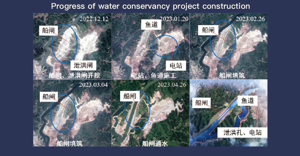
ระบบดาวเทียม Jilin-1 ซึ่งเป็นที่รู้จักจากความครอบคลุมข้อมูลการสำรวจระยะไกลอย่างครบถ้วนและความสามารถในการตรวจสอบซ้ำได้สูง มีบทบาทสำคัญในการติดตามและจัดการสิ่งอำนวยความสะดวกด้านการอนุรักษ์น้ำ เทคโนโลยีการถ่ายภาพขั้นสูงช่วยให้สามารถสังเกตโครงสร้างพื้นฐาน เช่น เขื่อน อ่างเก็บน้ำ ระบบชลประทาน และคันดินริมแม่น้ำได้ในความละเอียดสูงแบบเรียลไทม์ ซึ่งให้ข้อมูลสำคัญสำหรับการติดตามความคืบหน้าของการก่อสร้าง การประเมินความสมบูรณ์ของโครงสร้าง และการตรวจจับความเสี่ยงในระยะเริ่มต้น
ด้วยความสามารถในการตรวจสอบซ้ำความถี่สูง Jilin-1 สามารถจับภาพและอัปเดตภาพตำแหน่งเป้าหมายได้อย่างต่อเนื่อง ช่วยให้ตรวจจับการเปลี่ยนแปลงของระดับน้ำ เสถียรภาพของดิน และจุดอ่อนที่อาจเกิดขึ้นในโครงสร้างได้ทันท่วงที ความสามารถนี้มีประโยชน์อย่างยิ่งสำหรับการป้องกันภัยพิบัติ เนื่องจากช่วยให้หน่วยงานต่างๆ สามารถระบุความเสี่ยงต่างๆ เช่น ดินถล่ม การกัดเซาะเขื่อน และภัยคุกคามจากน้ำท่วมได้ก่อนที่ความเสี่ยงเหล่านั้นจะลุกลาม
Moreover, the satellite’s multi-spectral and high-resolution imaging enhances the ability to monitor environmental conditions around water conservancy projects, such as vegetation cover, sedimentation, and water pollution levels. This data supports decision-making for sustainable water resource management and climate adaptation strategies.
By integrating Jilin-1 remote sensing data with geographic information systems (GIS) and artificial intelligence, real-time monitoring and predictive analysis can be further enhanced, improving response efficiency and safety measures. The satellite’s capability to provide accurate and timely data reduces reliance on ground inspections, lowering operational costs and improving the overall resilience of water conservancy infrastructure. Thus, Jilin-1 serves as a powerful tool for governments, environmental agencies, and engineering firms to ensure the safety and efficiency of water-related projects.
