- אפריקאנער
- אַלבאַניש
- אַמהאַריש
- אַראַביש
- ארמאניש
- אַזערביידזשאַניש
- באַסק
- בעלאָרוסיש
- בענגאַליש
- באָסניש
- בולגאַריש
- קאַטאַלאַניש
- סעבואַנאָ
- כינע
- קאָרסיקאַן
- קראָאַטיש
- טשעכיש
- דאַניש
- האָלענדיש
- ענגליש
- עספּעראַנטאָ
- עסטיש
- פֿיניש
- פראנצויזיש
- פריזיש
- גאליציאנער
- גרוזיניש
- דײַטש
- גריכיש
- גודזשאַראַטי
- Haitian Creole
- האַוסאַ
- האַוואַייאַן
- העברעאיש
- ניין
- Miao
- אונגאַריש
- איסלענדיש
- igbo
- אינדאָנעזיש
- איריש
- איטאַליעניש
- יאַפּאַניש
- יאַוואַנעזיש
- קאַנאַדאַ
- קאַזאַך
- כמער
- רוואַנדאַן
- קאָרעיִש
- קורדיש
- קירגיזיש
- אַרבעט
- לאַטייַן
- לעטיש
- ליטוויש
- לוקסעמבאָורג
- מאַקעדאָניש
- מאַלאַגאַסי
- מאַלייַיש
- מאַלייַאַלאַם
- מאלטיזיש
- מאַאָרי
- מאַראַטהי
- מאָנגאָליש
- מיאַנמאַר
- נעפּאַליש
- נאָרוועגיש
- נאָרוועגיש
- אָקסיטאַן
- פּאַשטאָ
- פּערסיש
- פויליש
- פּאָרטוגעזיש
- פּונדזשאַבי
- רומעניש
- רוסיש
- Samoan
- סקאַטיש גאעליש
- סערביש
- ענגליש
- שאָנאַ
- סינדי
- סינהאַלאַ
- סלאָוואַקיש
- סלאָוועניש
- סאָמאַליש
- שפּאַניש
- סונדאַנעסע
- סוואַהילי
- שוועדיש
- Tagalog
- טאַדזשיק
- טאַמיל
- טאַטאַר
- טעלוגו
- טייַלענדיש
- טערקיש
- טורקמען
- אוקראַיִניש
- אורדו
- Uighur
- אוזבעקיש
- וויעטנאַמעזיש
- וועלש
- הילף
- יידיש
- יאָרובאַ
- זולו
וואַסער קאַנסערוואַנסי פּראָדוקטן און באַדינונגס
פּאַראַמעטער
|
Digital twin river basin standardized data base plate |
Water regulation |
|
DOM Data Backboard |
Establishment, revision and updating of reservoir capacity curve |
|
DEM/DSM Data Baseboard |
Irrigation area monitoring and water consumption calculation by remote sensing |
|
Flood and drought disaster monitoring services |
פּאַראַמעטער
|
River basin flood control project construction monitoring |
River and lake supervision (river and lake chief system management) |
|
Situation of Reservoir construction |
River and lake sand mining planning |
|
Safety of dam and reservoir bank |
River and lake remote sensing feature interpretation |
|
The construction of flood storage area |
Investigation of prominent problems hindering river flood flow |
|
River channels and beware of construction |
Planning for the protection of key river banks and shorelines |
|
|
"Normalize and standardize" the four disordered areas in Qing Dynasty |
|
|
The boundary data of shoreline spatial control of river and lake management waters are dynamically updated |
פּאַראַמעטער
|
Soil and water conservation supervision |
Supervision of water environment and water ecology |
|
Soil and Water Conservation |
Bloom monitoring |
|
Disturbance supervision |
Outfall monitoring |
|
Cage fish culture |
|
Marine regulation |
|
|
Coastlines, reefs and beaches monitoring |
|
|
Fishery resources Monitoring |
|
|
Enteromorpha and red tide monitoring |
|
|
Marine Disaster Warning
|
Application Of Monitoring The Construction Of Water Conservancy Facilities
For the full coverage of remote sensing data of Jilin-1 satellite and high revisit ability, it can timely monitor the construction of water conservancy facilities, dam and reservoir bank safety, flood storage area construction, river and guard construction, etc., assist the water conservancy department in the construction and management of water conservancy projects, improve the construction quality of water conservancy projects, and comprehensively understand the progress of the project.
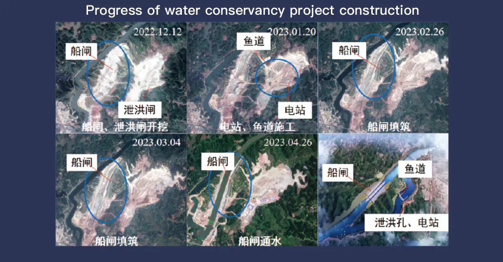
די Jilin-1 סאַטעליט סיסטעם, באַוווסט פֿאַר זיין פול קאַווערידזש פון ווייַט סענסינג דאַטן און הויך ריוויזיט פיייקייט, פיעסעס אַ קריטיש ראָלע אין די מאָניטאָרינג און פאַרוואַלטונג פון וואַסער קאַנסערוואַנסי פאַסילאַטיז. זיין אַוואַנסירטע ימאַגינג טעכנאָלאָגיע אַלאַוז פֿאַר הויך-האַכלאָטע, פאַקטיש-צייט אָבסערוואַציע פון ינפראַסטראַקטשער אַזאַ ווי דאַמז, רעזערוווואַרז, יראַגיישאַן סיסטעמען און טייַך עמבאַנגקמאַנץ, פּראַוויידינג יקערדיק דאַטן פֿאַר קאַנסטראַקשאַן פּראָגרעס טראַקינג, סטראַקטשעראַל אָרנטלעכקייַט אַסעסמאַנט און פרי ריזיקירן דיטעקשאַן.
מיט זיין הויך-אָפטקייַט ריוויזיט פיייקייט, Jilin-1 קענען קאַנטיניואַסלי כאַפּן און דערהייַנטיקן בילדער פון ציל לאָוקיישאַנז, ינשורינג בייַצייַטיק דיטעקשאַן פון ענדערונגען אין וואַסער לעוועלס, באָדן פעסטקייַט און פּאָטענציעל סטראַקטשעראַל וויקנאַסאַז. די פיייקייט איז דער הויפּט ווערטפול פֿאַר ומגליק פאַרהיטונג, ווייַל עס ינייבאַלז אויטאריטעטן צו ידענטיפיצירן ריסקס אַזאַ ווי לאַנדסליידז, דאַם יראָוזשאַן און מבול טרעץ איידער זיי עסקאַלייט.
Moreover, the satellite’s multi-spectral and high-resolution imaging enhances the ability to monitor environmental conditions around water conservancy projects, such as vegetation cover, sedimentation, and water pollution levels. This data supports decision-making for sustainable water resource management and climate adaptation strategies.
By integrating Jilin-1 remote sensing data with geographic information systems (GIS) and artificial intelligence, real-time monitoring and predictive analysis can be further enhanced, improving response efficiency and safety measures. The satellite’s capability to provide accurate and timely data reduces reliance on ground inspections, lowering operational costs and improving the overall resilience of water conservancy infrastructure. Thus, Jilin-1 serves as a powerful tool for governments, environmental agencies, and engineering firms to ensure the safety and efficiency of water-related projects.
