- አፍሪካዊ
- አልበንያኛ
- አማርኛ
- አረብኛ
- አርመንያኛ
- አዘርባጃኒ
- ባስክ
- ቤላሩሲያን
- ቤንጋሊ
- ቦስንያን
- ቡልጋርያኛ
- ካታሊያን
- ሴቡአኖ
- ቻይና
- ኮርሲካን
- ክሮኤሽያን
- ቼክ
- ዳኒሽ
- ደች
- እንግሊዝኛ
- እስፔራንቶ
- ኢስቶኒያን
- ፊኒሽ
- ፈረንሳይኛ
- ፍሪሲያን
- ጋላሺያን
- ጆርጅያን
- ጀርመንኛ
- ግሪክኛ
- ጉጅራቲ
- ሓይቲያን ክሬኦሌ
- ሃውሳ
- ሐዋያን
- ሂብሩ
- አይ
- ሚያኦ
- ሃንጋሪያን
- አይስላንዲ ክ
- igbo
- ኢንዶኔዥያን
- አይሪሽ
- ጣሊያንኛ
- ጃፓንኛ
- ጃቫኒስ
- ካናዳ
- ካዛክሀ
- ክመር
- ሩዋንዳኛ
- ኮሪያኛ
- ኩርዲሽ
- ክይርግያዝ
- የጉልበት ሥራ
- ላቲን
- ላትቪያን
- ሊቱኒያን
- ሉክዜምብርጊሽ
- ማስዶንያን
- ማላጋሲያ
- ማላይ
- ማላያላም
- ማልትስ
- ማኦሪይ
- ማራቲ
- ሞኒጎሊያን
- ማይንማር
- ኔፓሊ
- ኖርወይኛ
- ኖርወይኛ
- ኦሲታን
- ፓሽቶ
- ፐርሽያን
- ፖሊሽ
- ፖርቹጋልኛ
- ፑንጃቢ
- ሮማንያን
- ራሺያኛ
- ሳሞአን
- ስኮትላንዳዊ ጌሊክ
- ሰሪቢያን
- እንግሊዝኛ
- ሾና
- ስንድሂ
- ሲንሃላ
- ስሎቫክ
- ስሎቬንያን
- ሶማሊ
- ስፓንኛ
- ሱዳናዊ
- ስዋሕሊ
- ስዊድንኛ
- ታንጋሎግ
- ታጂክ
- ታሚል
- ታታር
- ተሉጉ
- ታይ
- ቱሪክሽ
- ቱሪክሜን
- ዩክሬንያን
- ኡርዱ
- ኡጉር
- ኡዝቤክ
- ቪትናሜሴ
- ዋልሽ
- እገዛ
- ዪዲሽ
- ዮሩባ
- ዙሉ
የውሃ ጥበቃ ምርቶች እና አገልግሎቶች
መለኪያ
|
Digital twin river basin standardized data base plate |
Water regulation |
|
DOM Data Backboard |
Establishment, revision and updating of reservoir capacity curve |
|
DEM/DSM Data Baseboard |
Irrigation area monitoring and water consumption calculation by remote sensing |
|
Flood and drought disaster monitoring services |
መለኪያ
|
River basin flood control project construction monitoring |
River and lake supervision (river and lake chief system management) |
|
Situation of Reservoir construction |
River and lake sand mining planning |
|
Safety of dam and reservoir bank |
River and lake remote sensing feature interpretation |
|
The construction of flood storage area |
Investigation of prominent problems hindering river flood flow |
|
River channels and beware of construction |
Planning for the protection of key river banks and shorelines |
|
|
"Normalize and standardize" the four disordered areas in Qing Dynasty |
|
|
The boundary data of shoreline spatial control of river and lake management waters are dynamically updated |
መለኪያ
|
Soil and water conservation supervision |
Supervision of water environment and water ecology |
|
Soil and Water Conservation |
Bloom monitoring |
|
Disturbance supervision |
Outfall monitoring |
|
Cage fish culture |
|
Marine regulation |
|
|
Coastlines, reefs and beaches monitoring |
|
|
Fishery resources Monitoring |
|
|
Enteromorpha and red tide monitoring |
|
|
Marine Disaster Warning
|
Application Of Monitoring The Construction Of Water Conservancy Facilities
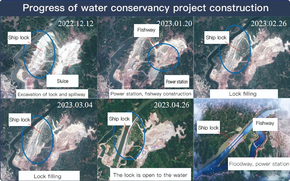
For the full coverage of remote sensing data of Jilin-1 satellite and high revisit ability, it can timely monitor the construction of water conservancy facilities, dam and reservoir bank safety, flood storage area construction, river and guard construction, etc., assist the water conservancy department in the construction and management of water conservancy projects, improve the construction quality of water conservancy projects, and comprehensively understand the progress of the project.
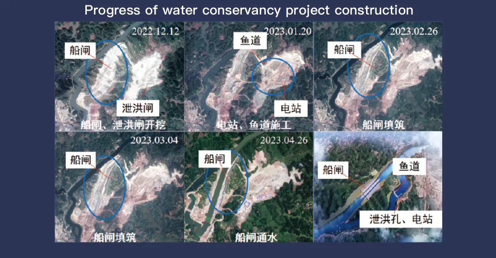
የጂሊን-1 ሳተላይት ሲስተም ሙሉ የርቀት ዳሰሳ መረጃን በመሸፈን እና በከፍተኛ የድጋሚ የመጎብኘት አቅም የሚታወቀው የውሃ ጥበቃ ተቋማትን በመቆጣጠር እና በማስተዳደር ረገድ ወሳኝ ሚና ይጫወታል። የእሱ የላቀ የምስል ቴክኖሎጂ ከፍተኛ ጥራት ያለው፣ እንደ ግድቦች፣ የውሃ ማጠራቀሚያዎች፣ የመስኖ ስርዓቶች እና የወንዞች ዳርቻ ያሉ መሠረተ ልማቶችን በእውነተኛ ጊዜ ለመመልከት ያስችላል።
በከፍተኛ ተደጋጋሚ የመጎብኘት ችሎታው ጂሊን-1 የታለሙ ቦታዎችን ምስሎችን በቀጣይነት ማንሳት እና ማዘመን ይችላል፣ የውሃ ደረጃዎች ለውጦችን በወቅቱ መለየት፣ የአፈር መረጋጋት እና ሊሆኑ የሚችሉ መዋቅራዊ ድክመቶች። ይህ አቅም በተለይ ለአደጋ መከላከል ጠቃሚ ነው፣ ምክንያቱም ባለሥልጣናቱ እንደ የመሬት መንሸራተት፣ የግድብ መሸርሸር እና የጎርፍ አደጋዎች ከመባባስዎ በፊት እንዲለዩ ያስችላቸዋል።
Moreover, the satellite’s multi-spectral and high-resolution imaging enhances the ability to monitor environmental conditions around water conservancy projects, such as vegetation cover, sedimentation, and water pollution levels. This data supports decision-making for sustainable water resource management and climate adaptation strategies.
By integrating Jilin-1 remote sensing data with geographic information systems (GIS) and artificial intelligence, real-time monitoring and predictive analysis can be further enhanced, improving response efficiency and safety measures. The satellite’s capability to provide accurate and timely data reduces reliance on ground inspections, lowering operational costs and improving the overall resilience of water conservancy infrastructure. Thus, Jilin-1 serves as a powerful tool for governments, environmental agencies, and engineering firms to ensure the safety and efficiency of water-related projects.
