- 아프리카 사람
- 알바니아
- 암하라어
- 아라비아 말
- 아르메니아 사람
- 아제르바이잔
- 바스크 사람
- 벨로루시어
- 벵골 사람
- 보스니아어
- 불가리아 사람
- 카탈로니아 사람
- 세부아노어
- 중국
- 코르시카어
- 크로아티아어
- 체코 사람
- 덴마크 말
- 네덜란드 사람
- 영어
- 에스페란토 말
- 에스토니아 사람
- 핀란드어
- 프랑스 국민
- 프리지아어
- 갈리시아어
- 그루지야 사람
- 독일 사람
- 그리스 사람
- 구자라트어
- 아이티 크리올어
- 하우사어
- 하와이안
- 헤브라이 사람
- 아니요
- 미아오
- 헝가리 인
- 아이슬란드어
- 이그보
- 인도네시아 인
- 아일랜드
- 이탈리아 사람
- 일본어
- 자바어
- 칸나다어
- 카자흐어
- 크메르어
- 르완다
- 한국인
- 쿠르드어
- 키르기스어
- 노동
- 라틴어
- 라트비아 사람
- 리투아니아 사람
- 룩셈부르크어
- 마케도니아 어
- 마다가스카르 사람
- 말레이 사람
- 말라얄람어
- 몰티즈
- 마오리족
- 마라티어
- 몽고 어
- 미얀마
- 네팔어
- 노르웨이 인
- 노르웨이 인
- 오크어
- 파슈토어
- 페르시아 인
- 광택
- 포르투갈 인
- 펀잡어
- 루마니아 사람
- 러시아인
- 사모아어
- 스코틀랜드 게일어
- 세르비아 사람
- 영어
- 쇼나어
- 신디어
- 싱할라어
- 슬로바키아 사람
- 슬로베니아
- 소말리아어
- 스페인 사람
- 순다어
- 스와힐리어
- 스웨덴어
- 타갈로그어
- 타지크어
- 타밀 사람
- 타타르어
- 텔루구어
- 태국어
- 터키어
- 투르크멘 말
- 우크라이나 말
- 우르두어
- 위구르어
- 우즈베크어
- 베트남 사람
- 웨일스 말
- 돕다
- 이디시어
- 요루바어
- 줄루 족
매개변수
|
Digital twin river basin standardized data base plate |
Water regulation |
|
DOM Data Backboard |
Establishment, revision and updating of reservoir capacity curve |
|
DEM/DSM Data Baseboard |
Irrigation area monitoring and water consumption calculation by remote sensing |
|
Flood and drought disaster monitoring services |
매개변수
|
River basin flood control project construction monitoring |
River and lake supervision (river and lake chief system management) |
|
Situation of Reservoir construction |
River and lake sand mining planning |
|
Safety of dam and reservoir bank |
River and lake remote sensing feature interpretation |
|
The construction of flood storage area |
Investigation of prominent problems hindering river flood flow |
|
River channels and beware of construction |
Planning for the protection of key river banks and shorelines |
|
|
"Normalize and standardize" the four disordered areas in Qing Dynasty |
|
|
The boundary data of shoreline spatial control of river and lake management waters are dynamically updated |
매개변수
|
Soil and water conservation supervision |
Supervision of water environment and water ecology |
|
Soil and Water Conservation |
Bloom monitoring |
|
Disturbance supervision |
Outfall monitoring |
|
Cage fish culture |
|
Marine regulation |
|
|
Coastlines, reefs and beaches monitoring |
|
|
Fishery resources Monitoring |
|
|
Enteromorpha and red tide monitoring |
|
|
Marine Disaster Warning
|
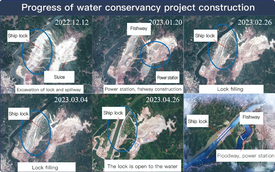
Application Of Monitoring The Construction Of Water Conservancy Facilities
For the full coverage of remote sensing data of Jilin-1 satellite and high revisit ability, it can timely monitor the construction of water conservancy facilities, dam and reservoir bank safety, flood storage area construction, river and guard construction, etc., assist the water conservancy department in the construction and management of water conservancy projects, improve the construction quality of water conservancy projects, and comprehensively understand the progress of the project.
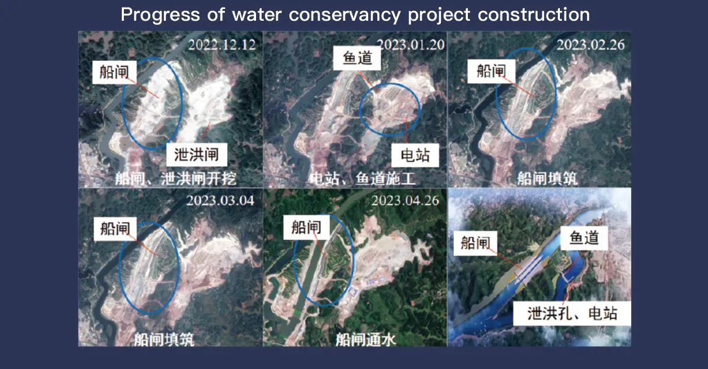
원격 감지 데이터의 전체 범위와 높은 재방문 기능으로 유명한 지린-1 위성 시스템은 수자원 보호 시설의 모니터링 및 관리에 중요한 역할을 합니다. 첨단 이미징 기술을 통해 댐, 저수지, 관개 시스템, 강 제방과 같은 인프라를 고해상도로 실시간으로 관찰할 수 있어 건설 진행 상황 추적, 구조적 무결성 평가, 조기 위험 감지에 필수적인 데이터를 제공합니다.
Jilin-1은 고주파 재방문 기능을 통해 대상 위치의 이미지를 지속적으로 캡처하고 업데이트하여 수위, 토양 안정성 및 잠재적인 구조적 약점의 변화를 적시에 감지할 수 있습니다. 이 기능은 특히 재난 예방에 가치가 있는데, 당국이 산사태, 댐 침식 및 홍수 위협과 같은 위험이 커지기 전에 이를 식별할 수 있기 때문입니다.
Moreover, the satellite’s multi-spectral and high-resolution imaging enhances the ability to monitor environmental conditions around water conservancy projects, such as vegetation cover, sedimentation, and water pollution levels. This data supports decision-making for sustainable water resource management and climate adaptation strategies.
By integrating Jilin-1 remote sensing data with geographic information systems (GIS) and artificial intelligence, real-time monitoring and predictive analysis can be further enhanced, improving response efficiency and safety measures. The satellite’s capability to provide accurate and timely data reduces reliance on ground inspections, lowering operational costs and improving the overall resilience of water conservancy infrastructure. Thus, Jilin-1 serves as a powerful tool for governments, environmental agencies, and engineering firms to ensure the safety and efficiency of water-related projects.
