- アフリカ
- アルバニア語
- アムハラ語
- アラビア語
- アルメニア語
- アゼルバイジャン語
- バスク語
- ベラルーシ語
- ベンガル語
- ボスニア語
- ブルガリア語
- カタロニア語
- セブアノ語
- 中国
- コルシカ
- クロアチア語
- チェコ語
- デンマーク語
- オランダ語
- 英語
- エスペラント
- エストニア語
- フィンランド語
- フランス語
- フリジア語
- ガリシア語
- グルジア語
- ドイツ語
- ギリシャ語
- グジャラート語
- ハイチ語
- ハウサ語
- ハワイアン
- ヘブライ語
- いいえ
- ミャオ族
- ハンガリー語
- アイスランド語
- イボ語
- インドネシア語
- アイルランド人
- イタリア語
- 日本語
- ジャワ語
- カンナダ語
- カザフ語
- クメール語
- ルワンダ
- 韓国語
- クルド
- キルギス語
- 労働
- ラテン
- ラトビア語
- リトアニア語
- ルクセンブルク語
- マケドニア語
- マダガスカル語
- マレー語
- マラヤーラム語
- マルタ語
- マオリ語
- マラーティー語
- モンゴル語
- ミャンマー
- ネパール語
- ノルウェー語
- ノルウェー語
- オック語
- パシュトゥー語
- ペルシャ語
- 研磨
- ポルトガル語
- パンジャブ語
- ルーマニア語
- ロシア
- サモア語
- スコットランド・ゲール語
- セルビア語
- 英語
- ショナ語
- シンディー語
- シンハラ語
- スロバキア語
- スロベニア語
- ソマリア
- スペイン語
- スンダ語
- スワヒリ語
- スウェーデン語
- タガログ語
- タジク語
- タミル語
- タタール語
- テルグ語
- タイ語
- トルコ語
- トルクメン語
- ウクライナ語
- ウルドゥー語
- ウイグル
- ウズベク語
- ベトナム語
- ウェールズ語
- ヘルプ
- イディッシュ語
- ヨルバ語
- ズールー語
パラメータ
|
Digital twin river basin standardized data base plate |
Water regulation |
|
DOM Data Backboard |
Establishment, revision and updating of reservoir capacity curve |
|
DEM/DSM Data Baseboard |
Irrigation area monitoring and water consumption calculation by remote sensing |
|
Flood and drought disaster monitoring services |
パラメータ
|
River basin flood control project construction monitoring |
River and lake supervision (river and lake chief system management) |
|
Situation of Reservoir construction |
River and lake sand mining planning |
|
Safety of dam and reservoir bank |
River and lake remote sensing feature interpretation |
|
The construction of flood storage area |
Investigation of prominent problems hindering river flood flow |
|
River channels and beware of construction |
Planning for the protection of key river banks and shorelines |
|
|
"Normalize and standardize" the four disordered areas in Qing Dynasty |
|
|
The boundary data of shoreline spatial control of river and lake management waters are dynamically updated |
パラメータ
|
Soil and water conservation supervision |
Supervision of water environment and water ecology |
|
Soil and Water Conservation |
Bloom monitoring |
|
Disturbance supervision |
Outfall monitoring |
|
Cage fish culture |
|
Marine regulation |
|
|
Coastlines, reefs and beaches monitoring |
|
|
Fishery resources Monitoring |
|
|
Enteromorpha and red tide monitoring |
|
|
Marine Disaster Warning
|
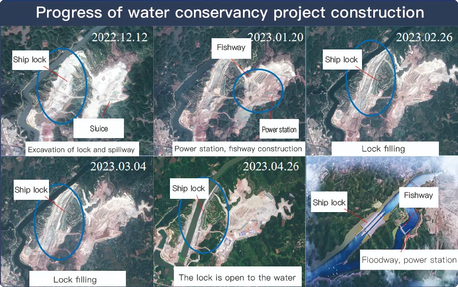
Application Of Monitoring The Construction Of Water Conservancy Facilities
For the full coverage of remote sensing data of Jilin-1 satellite and high revisit ability, it can timely monitor the construction of water conservancy facilities, dam and reservoir bank safety, flood storage area construction, river and guard construction, etc., assist the water conservancy department in the construction and management of water conservancy projects, improve the construction quality of water conservancy projects, and comprehensively understand the progress of the project.
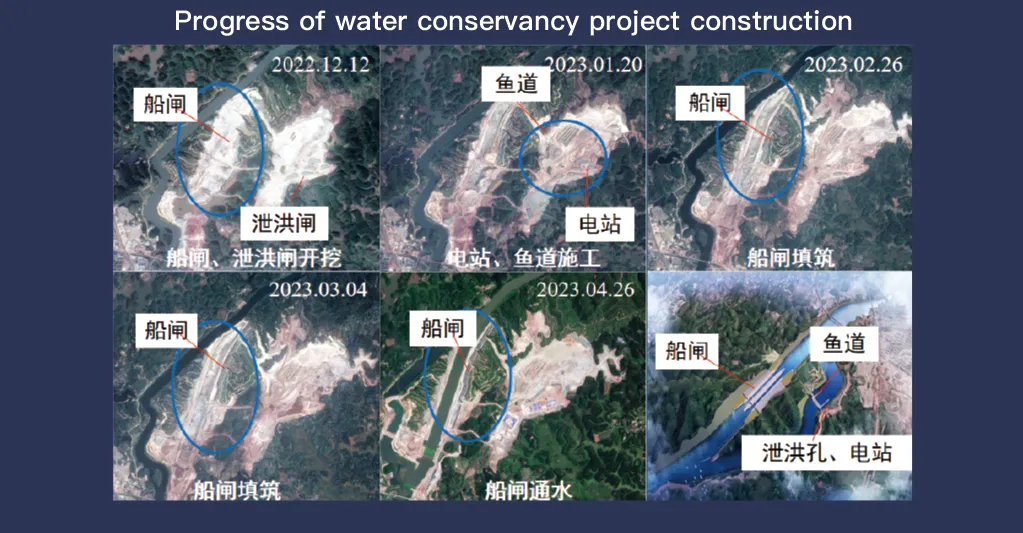
リモートセンシングデータの完全なカバレッジと高い再訪能力で知られる吉林1号衛星システムは、水利施設の監視と管理において重要な役割を果たしています。その高度な画像技術により、ダム、貯水池、灌漑システム、河川堤防などのインフラの高解像度のリアルタイム観測が可能になり、建設の進捗状況の追跡、構造の健全性評価、早期リスク検出に不可欠なデータを提供します。
吉林1号は高頻度の再訪問能力を備えており、対象地点の画像を継続的に撮影して更新し、水位の変化、土壌の安定性、構造上の潜在的な弱点をタイムリーに検出できます。この機能により、当局は地滑り、ダムの浸食、洪水の脅威などのリスクを、それが深刻化する前に特定できるため、特に防災に役立ちます。
Moreover, the satellite’s multi-spectral and high-resolution imaging enhances the ability to monitor environmental conditions around water conservancy projects, such as vegetation cover, sedimentation, and water pollution levels. This data supports decision-making for sustainable water resource management and climate adaptation strategies.
By integrating Jilin-1 remote sensing data with geographic information systems (GIS) and artificial intelligence, real-time monitoring and predictive analysis can be further enhanced, improving response efficiency and safety measures. The satellite’s capability to provide accurate and timely data reduces reliance on ground inspections, lowering operational costs and improving the overall resilience of water conservancy infrastructure. Thus, Jilin-1 serves as a powerful tool for governments, environmental agencies, and engineering firms to ensure the safety and efficiency of water-related projects.
