- Affricanaidd
- Albaneg
- Amhareg
- Arabeg
- Armenaidd
- Azerbaijani
- Basgeg
- Belarwseg
- Bengali
- Bosnieg
- Bwlgareg
- Catalaneg
- Cebuano
- Tsieina
- Corseg
- Croateg
- Tsiec
- Daneg
- Iseldireg
- Saesneg
- Esperanto
- Estoneg
- Ffinneg
- Ffrangeg
- Ffriseg
- Galiseg
- Sioraidd
- Almaeneg
- Groeg
- Gwjarati
- Creol Haitaidd
- Hawsa
- hawaiian
- Hebraeg
- Nac ydw
- Miao
- Hwngareg
- Islandeg
- igbo
- Indoneseg
- gwyddelig
- Eidaleg
- Japaneaidd
- Jafaneg
- Kannada
- kazakh
- Khmer
- Rwanda
- Corëeg
- Cwrdaidd
- Kyrgyz
- Llafur
- Lladin
- Latfieg
- Lithwaneg
- Lwcsembwrgaidd
- Macedoneg
- Malagaseg
- Maleieg
- Malayalam
- Malteg
- Maori
- Marathi
- Mongoleg
- Myanmar
- Nepali
- Norwyaidd
- Norwyaidd
- Ocsitaneg
- Pashto
- Perseg
- Pwyleg
- Portiwgaleg
- Pwnjabi
- Rwmania
- Rwsiaidd
- Samoaidd
- Gaeleg yr Alban
- Serbeg
- Saesneg
- Shona
- Sindhi
- Sinhala
- Slofaceg
- Slofeneg
- Somalïaidd
- Sbaeneg
- Sundanaidd
- Swahili
- Swedeg
- Tagalog
- Tajiceg
- Tamil
- Tatar
- Telugu
- Thai
- Twrceg
- Tyrcmeniaid
- Wcrain
- Wrdw
- Uighur
- Wsbeceg
- Fietnameg
- Cymraeg
- Help
- Iddeweg
- Iorwba
- Zwlw
Cynhyrchion a Gwasanaethau Gwarchod Dŵr
paramedr
|
Digital twin river basin standardized data base plate |
Water regulation |
|
DOM Data Backboard |
Establishment, revision and updating of reservoir capacity curve |
|
DEM/DSM Data Baseboard |
Irrigation area monitoring and water consumption calculation by remote sensing |
|
Flood and drought disaster monitoring services |
paramedr
|
River basin flood control project construction monitoring |
River and lake supervision (river and lake chief system management) |
|
Situation of Reservoir construction |
River and lake sand mining planning |
|
Safety of dam and reservoir bank |
River and lake remote sensing feature interpretation |
|
The construction of flood storage area |
Investigation of prominent problems hindering river flood flow |
|
River channels and beware of construction |
Planning for the protection of key river banks and shorelines |
|
|
"Normalize and standardize" the four disordered areas in Qing Dynasty |
|
|
The boundary data of shoreline spatial control of river and lake management waters are dynamically updated |
paramedr
|
Soil and water conservation supervision |
Supervision of water environment and water ecology |
|
Soil and Water Conservation |
Bloom monitoring |
|
Disturbance supervision |
Outfall monitoring |
|
Cage fish culture |
|
Marine regulation |
|
|
Coastlines, reefs and beaches monitoring |
|
|
Fishery resources Monitoring |
|
|
Enteromorpha and red tide monitoring |
|
|
Marine Disaster Warning
|
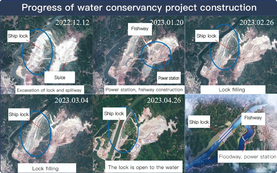
Application Of Monitoring The Construction Of Water Conservancy Facilities
For the full coverage of remote sensing data of Jilin-1 satellite and high revisit ability, it can timely monitor the construction of water conservancy facilities, dam and reservoir bank safety, flood storage area construction, river and guard construction, etc., assist the water conservancy department in the construction and management of water conservancy projects, improve the construction quality of water conservancy projects, and comprehensively understand the progress of the project.
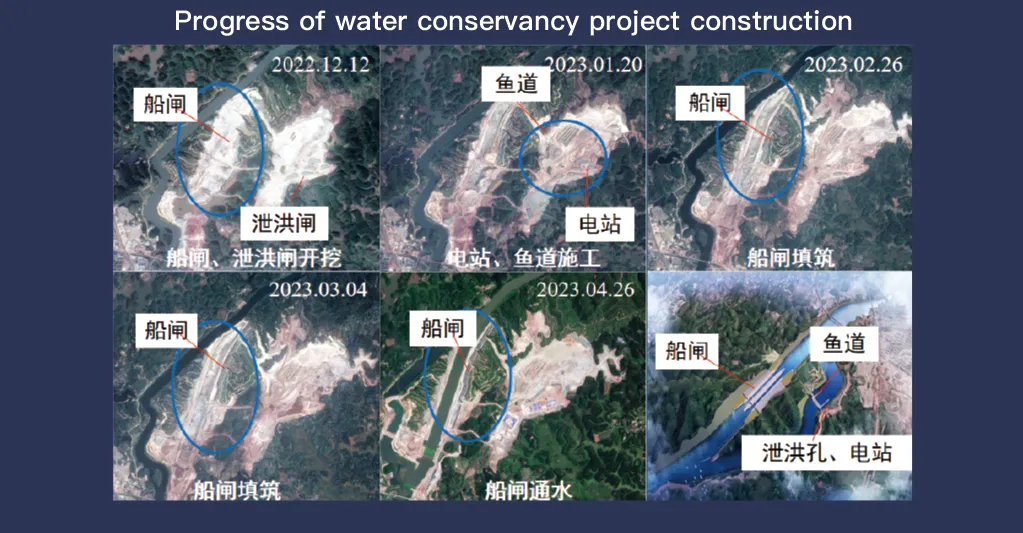
Mae system loeren Jilin-1, sy'n adnabyddus am ei chwmpas llawn o ddata synhwyro o bell a gallu ailymweld uchel, yn chwarae rhan hanfodol wrth fonitro a rheoli cyfleusterau cadwraeth dŵr. Mae ei dechnoleg delweddu uwch yn caniatáu arsylwi cydraniad uchel, amser real o seilwaith fel argaeau, cronfeydd dŵr, systemau dyfrhau, ac argloddiau afonydd, gan ddarparu data hanfodol ar gyfer olrhain cynnydd adeiladu, asesu cyfanrwydd strwythurol, a chanfod risg yn gynnar.
Gyda'i allu ailymweld amledd uchel, gall Jilin-1 ddal a diweddaru delweddau o leoliadau targed yn barhaus, gan sicrhau bod newidiadau mewn lefelau dŵr, sefydlogrwydd pridd, a gwendidau strwythurol posibl yn cael eu canfod yn amserol. Mae'r gallu hwn yn arbennig o werthfawr ar gyfer atal trychinebau, gan ei fod yn galluogi awdurdodau i nodi risgiau megis tirlithriadau, erydiad argaeau, a bygythiadau llifogydd cyn iddynt waethygu.
Moreover, the satellite’s multi-spectral and high-resolution imaging enhances the ability to monitor environmental conditions around water conservancy projects, such as vegetation cover, sedimentation, and water pollution levels. This data supports decision-making for sustainable water resource management and climate adaptation strategies.
By integrating Jilin-1 remote sensing data with geographic information systems (GIS) and artificial intelligence, real-time monitoring and predictive analysis can be further enhanced, improving response efficiency and safety measures. The satellite’s capability to provide accurate and timely data reduces reliance on ground inspections, lowering operational costs and improving the overall resilience of water conservancy infrastructure. Thus, Jilin-1 serves as a powerful tool for governments, environmental agencies, and engineering firms to ensure the safety and efficiency of water-related projects.
