- Āfrikas
- albānis
- amharu
- arābu
- armēņu
- Azerbaidžāņu
- basku
- baltkrievu
- bengāļu
- bosniešu
- bulgāru valoda
- katalāņu
- Cebuano
- Ķīna
- Korsikānis
- horvātu
- čehu
- dāņu
- holandiešu valoda
- angļu valoda
- Esperanto
- igauņu
- somu
- franču valoda
- frīzu valoda
- Galisiešu
- gruzīnu
- vācu
- grieķu valoda
- gudžaratu
- Haiti kreols
- Hausa
- havajietis
- ebreju valoda
- Nē
- Miao
- ungāru
- islandiešu
- igbo
- Indonēziešu
- īru
- itāļu valoda
- japāņi
- javiešu
- kannada
- kazahu
- khmeru
- Ruandā
- korejiešu
- kurdu
- Kirgizstānas
- Darbaspēks
- latīņu valoda
- latviski
- lietuviešu
- luksemburgiešu
- maķedonietis
- malagasu
- malajiešu
- malajalu
- maltiešu
- maori
- maratu
- mongoļu valoda
- Mjanma
- Nepāliešu
- norvēģu
- norvēģu
- oksitāņu
- puštu
- persiešu
- poļu
- portugāļu
- pandžabu
- rumāņu
- krievu valoda
- Samoa
- skotu gēlu valoda
- serbu
- angļu valoda
- Šona
- Sindhi
- singalu valoda
- slovāku
- slovēņu
- somāliešu
- spāņu valoda
- sundāņu
- svahili
- zviedru
- tagalogs
- tadžiks
- tamilu
- tatārs
- telugu
- taju
- turku
- Turkmēņu
- ukraiņu
- urdu
- Uiguru
- uzbeku
- vjetnamietis
- velsiešu
- Palīdzība
- jidiša
- Joruba
- zulu
Ūdens aizsardzības produkti un pakalpojumi
parametrs
|
Digital twin river basin standardized data base plate |
Water regulation |
|
DOM Data Backboard |
Establishment, revision and updating of reservoir capacity curve |
|
DEM/DSM Data Baseboard |
Irrigation area monitoring and water consumption calculation by remote sensing |
|
Flood and drought disaster monitoring services |
parametrs
|
River basin flood control project construction monitoring |
River and lake supervision (river and lake chief system management) |
|
Situation of Reservoir construction |
River and lake sand mining planning |
|
Safety of dam and reservoir bank |
River and lake remote sensing feature interpretation |
|
The construction of flood storage area |
Investigation of prominent problems hindering river flood flow |
|
River channels and beware of construction |
Planning for the protection of key river banks and shorelines |
|
|
"Normalize and standardize" the four disordered areas in Qing Dynasty |
|
|
The boundary data of shoreline spatial control of river and lake management waters are dynamically updated |
parametrs
|
Soil and water conservation supervision |
Supervision of water environment and water ecology |
|
Soil and Water Conservation |
Bloom monitoring |
|
Disturbance supervision |
Outfall monitoring |
|
Cage fish culture |
|
Marine regulation |
|
|
Coastlines, reefs and beaches monitoring |
|
|
Fishery resources Monitoring |
|
|
Enteromorpha and red tide monitoring |
|
|
Marine Disaster Warning
|
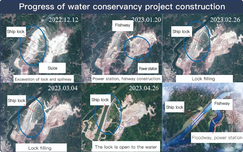
Application Of Monitoring The Construction Of Water Conservancy Facilities
For the full coverage of remote sensing data of Jilin-1 satellite and high revisit ability, it can timely monitor the construction of water conservancy facilities, dam and reservoir bank safety, flood storage area construction, river and guard construction, etc., assist the water conservancy department in the construction and management of water conservancy projects, improve the construction quality of water conservancy projects, and comprehensively understand the progress of the project.
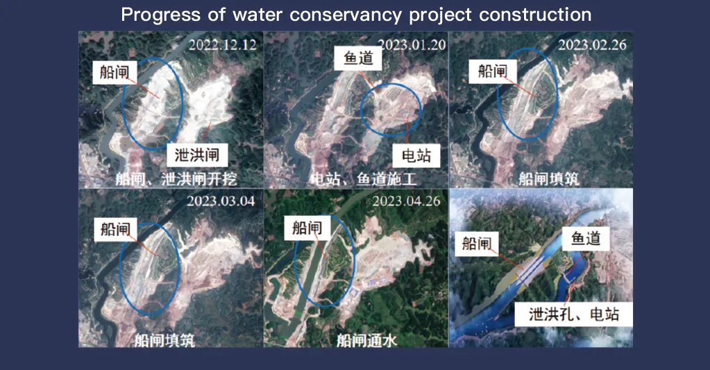
Jilin-1 satelītu sistēmai, kas ir pazīstama ar pilnu attālās uzrādes datu pārklājumu un augstu atkārtotas apmeklēšanas iespēju, ir izšķiroša nozīme ūdens aizsardzības iekārtu uzraudzībā un pārvaldībā. Tā uzlabotā attēlveidošanas tehnoloģija nodrošina augstas izšķirtspējas reāllaika infrastruktūru, piemēram, dambju, rezervuāru, apūdeņošanas sistēmu un upju uzbērumu novērošanu, nodrošinot būtiskus datus būvniecības progresa izsekošanai, struktūras integritātes novērtēšanai un agrīnai riska noteikšanai.
Ar savu augstfrekvences atkārtotas apskates iespēju Jilin-1 var nepārtraukti uzņemt un atjaunināt mērķa vietu attēlus, nodrošinot savlaicīgu ūdens līmeņa izmaiņu, augsnes stabilitātes un iespējamo strukturālo trūkumu noteikšanu. Šī iespēja ir īpaši vērtīga katastrofu novēršanā, jo tā ļauj iestādēm identificēt tādus riskus kā zemes nogruvumi, dambju erozija un plūdu draudi, pirms tie saasinās.
Moreover, the satellite’s multi-spectral and high-resolution imaging enhances the ability to monitor environmental conditions around water conservancy projects, such as vegetation cover, sedimentation, and water pollution levels. This data supports decision-making for sustainable water resource management and climate adaptation strategies.
By integrating Jilin-1 remote sensing data with geographic information systems (GIS) and artificial intelligence, real-time monitoring and predictive analysis can be further enhanced, improving response efficiency and safety measures. The satellite’s capability to provide accurate and timely data reduces reliance on ground inspections, lowering operational costs and improving the overall resilience of water conservancy infrastructure. Thus, Jilin-1 serves as a powerful tool for governments, environmental agencies, and engineering firms to ensure the safety and efficiency of water-related projects.
