- Afrika
- Albania
- Amharic
- Arabic
- Armenian
- Azerbaijani
- Basque
- Belarusian
- Bengali
- Asụsụ Bosnia
- Bulgarian
- Catalan
- Cebuano
- China
- Corsican
- Asụsụ Croatia
- Czech
- Danish
- Dutch
- Bekee
- Esperanto
- Estonia
- Asụsụ Finnish
- French
- Onye Frisian
- Onye Galisi
- Asụsụ Georgian
- German
- Grik
- Gujarati
- Haitian Creole
- Hausa
- Hawaian
- Hibru
- Mba
- Miao
- Asụsụ Hungarian
- Aislandi
- igbo
- Asụsụ Indonesian
- Irish
- Ịtali
- Japanese
- Asụsụ Javanị
- Kannada
- kazakh
- Khmer
- Onye Rwandan
- Korean
- Kurdish
- Kyrgyz
- Ịrụ ọrụ
- Latịn
- Latvia
- Lithuania
- Luxembourgish
- Masedonia
- Malagasy
- Malay
- Malayalam
- Malta
- Maori
- Marathi
- Mongolian
- Myanmar
- Nepali
- Norwegian
- Norwegian
- Occitan
- Pashto
- Asụsụ Persia
- Polish
- Portuguese
- Punjabi
- Romanian
- Russian
- Samoan
- Scottish Gaelic
- Asụsụ Serbian
- Bekee
- Shona
- Sindhi
- Sinhala
- Slovak
- Slovenian
- Somali
- Spanish
- Asụsụ Sudan
- Swahili
- Swedish
- Tagalog
- Tajik
- Tamil
- Tatar
- Telugu
- Thai
- Turkish
- Turkmen
- onye Ukraine
- Urdu
- Uighur
- Uzbek
- Vietnamese
- Welsh
- Enyemaka
- Yiddish
- Yoruba
- Zulu
Ngwaahịa na ọrụ nchekwa mmiri

oke
|
Digital twin river basin standardized data base plate |
Water regulation |
|
DOM Data Backboard |
Establishment, revision and updating of reservoir capacity curve |
|
DEM/DSM Data Baseboard |
Irrigation area monitoring and water consumption calculation by remote sensing |
|
Flood and drought disaster monitoring services |
oke
|
River basin flood control project construction monitoring |
River and lake supervision (river and lake chief system management) |
|
Situation of Reservoir construction |
River and lake sand mining planning |
|
Safety of dam and reservoir bank |
River and lake remote sensing feature interpretation |
|
The construction of flood storage area |
Investigation of prominent problems hindering river flood flow |
|
River channels and beware of construction |
Planning for the protection of key river banks and shorelines |
|
|
"Normalize and standardize" the four disordered areas in Qing Dynasty |
|
|
The boundary data of shoreline spatial control of river and lake management waters are dynamically updated |
oke
|
Soil and water conservation supervision |
Supervision of water environment and water ecology |
|
Soil and Water Conservation |
Bloom monitoring |
|
Disturbance supervision |
Outfall monitoring |
|
Cage fish culture |
|
Marine regulation |
|
|
Coastlines, reefs and beaches monitoring |
|
|
Fishery resources Monitoring |
|
|
Enteromorpha and red tide monitoring |
|
|
Marine Disaster Warning
|
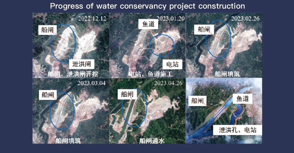
Application Of Monitoring The Construction Of Water Conservancy Facilities
For the full coverage of remote sensing data of Jilin-1 satellite and high revisit ability, it can timely monitor the construction of water conservancy facilities, dam and reservoir bank safety, flood storage area construction, river and guard construction, etc., assist the water conservancy department in the construction and management of water conservancy projects, improve the construction quality of water conservancy projects, and comprehensively understand the progress of the project.
Sistemụ satịlaịtị Jilin-1, nke amaara maka mkpuchi zuru oke nke data nhụta anya yana ikike nlegharị anya dị elu, na-arụ ọrụ dị oke mkpa na nlekota na njikwa nke akụrụngwa nchekwa mmiri. Nkà na ụzụ onyonyo ya dị elu na-enye ohere maka mkpebi dị elu, nleba anya n'ezie nke akụrụngwa dị ka dams, reservoirs, sistemu ogbugba mmiri, na mkpọda osimiri, na-enye data dị mkpa maka nleba anya ọganihu ihe owuwu, ntule nguzosi ike n'ezi ihe, na nchọpụta ihe egwu mmalite.
Site n'ikike nlegharị anya ugboro ugboro dị elu, Jilin-1 nwere ike na-aga n'ihu na-esetịpụ ma na-emelite onyonyo nke ebe ebumnuche, na-ahụ n'oge na-achọpụta mgbanwe na ọkwa mmiri, nkwụsi ike ala, na adịghị ike nhazi. Ikike a bara uru karịsịa maka igbochi ọdachi, n'ihi na ọ na-enyere ndị ọchịchị aka ịchọpụta ihe ize ndụ dị ka mbuze ala, mmebi mmiri mmiri, na iyi egwu idei mmiri tupu ha apụta.
Ọzọkwa, ihe onyonyo dị iche iche na nke dị elu nke satịlaịtị na-eme ka ike nyochaa ọnọdụ gburugburu ebe obibi gburugburu ọrụ nchekwa mmiri, dị ka mkpuchi ahịhịa, sedimentation, na ọkwa mmetọ mmiri. Ihe omuma a na-akwado ime mkpebi maka njikwa akụrụngwa mmiri na-adịgide adịgide na atụmatụ mgbanwe ihu igwe.
Site na ijikọ Jilin-1 remote sensing data na sistemụ ozi mpaghara (GIS) na ọgụgụ isi, enwere ike ịkwalite nlekota oge na nyocha amụma, na-eme ka arụmọrụ nzaghachi na usoro nchekwa dịkwuo mma. Ikike nke satịlaịtị inye data ziri ezi na nke oge na-ebelata ịdabere na nyocha ala, na-ebelata ụgwọ ọrụ yana imeziwanye nkwụsi ike nke akụrụngwa nchekwa mmiri. Ya mere, Jilin-1 na-eje ozi dị ka ngwá ọrụ dị ike maka gọọmentị, ụlọ ọrụ gburugburu ebe obibi, na ụlọ ọrụ injinịa iji hụ na nchekwa na arụmọrụ nke ọrụ metụtara mmiri.


