- Aprikano
- Albaniano
- Amharic
- Arabiko
- Armenian
- Azerbaijani
- Basque
- Belarusian
- Bengali
- Bosnian
- Bulgarian
- Catalan
- Cebuano
- China
- Corsican
- Croatiano
- Czech
- Danish
- Dutch
- English
- Esperanto
- Estonian
- Finnish
- Pranses
- Frisian
- Galician
- Georgian
- Aleman
- Griyego
- Gujarati
- Haitian Creole
- Hausa
- hawaiian
- Hebreohanon
- Dili
- Miao
- Hungarian
- Icelandic
- igbo
- Indonesian
- irish
- Italyano
- Hapon
- Javanese
- Kannada
- kazakh
- Khmer
- Rwandan
- Koreano
- Kurdish
- Kyrgyz
- Pagtrabaho
- Latin
- Latviano
- Lithuanian
- Luxembourgish
- Macedonian
- Malagasy
- Malay
- Malayalam
- Maltese
- Maori
- Marathi
- Mongolian
- Myanmar
- Nepali
- Norwegian
- Norwegian
- Occitan
- Pashto
- Persianhon
- Polish
- Portuges
- Punjabi
- Romaniano
- Ruso
- Samoano
- Scottish Gaelic
- Serbiano
- English
- Shona
- Sindhi
- Sinhala
- Slovak
- Slovenian
- Somali
- Kinatsila
- Sundanese
- Swahili
- Swedish
- Tagalog
- Tajik
- Tamil
- Tatar
- Telugu
- Thai
- Turko
- Turkmen
- Ukrainiano
- Urdu
- Uighur
- Uzbek
- Vietnamese
- Welsh
- Tabang
- Yiddish
- Yoruba
- Zulu
Mga Produkto ug Serbisyo sa Pagkonserba sa Tubig
parametro
|
Digital twin river basin standardized data base plate |
Water regulation |
|
DOM Data Backboard |
Establishment, revision and updating of reservoir capacity curve |
|
DEM/DSM Data Baseboard |
Irrigation area monitoring and water consumption calculation by remote sensing |
|
Flood and drought disaster monitoring services |
parametro
|
River basin flood control project construction monitoring |
River and lake supervision (river and lake chief system management) |
|
Situation of Reservoir construction |
River and lake sand mining planning |
|
Safety of dam and reservoir bank |
River and lake remote sensing feature interpretation |
|
The construction of flood storage area |
Investigation of prominent problems hindering river flood flow |
|
River channels and beware of construction |
Planning for the protection of key river banks and shorelines |
|
|
"Normalize and standardize" the four disordered areas in Qing Dynasty |
|
|
The boundary data of shoreline spatial control of river and lake management waters are dynamically updated |
parametro
|
Soil and water conservation supervision |
Supervision of water environment and water ecology |
|
Soil and Water Conservation |
Bloom monitoring |
|
Disturbance supervision |
Outfall monitoring |
|
Cage fish culture |
|
Marine regulation |
|
|
Coastlines, reefs and beaches monitoring |
|
|
Fishery resources Monitoring |
|
|
Enteromorpha and red tide monitoring |
|
|
Marine Disaster Warning
|
Application Of Monitoring The Construction Of Water Conservancy Facilities
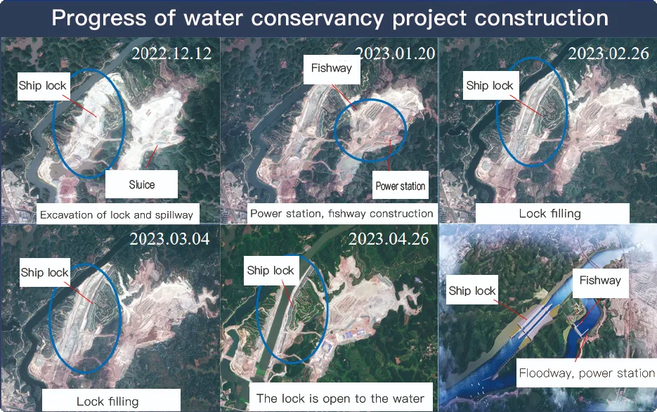
For the full coverage of remote sensing data of Jilin-1 satellite and high revisit ability, it can timely monitor the construction of water conservancy facilities, dam and reservoir bank safety, flood storage area construction, river and guard construction, etc., assist the water conservancy department in the construction and management of water conservancy projects, improve the construction quality of water conservancy projects, and comprehensively understand the progress of the project.
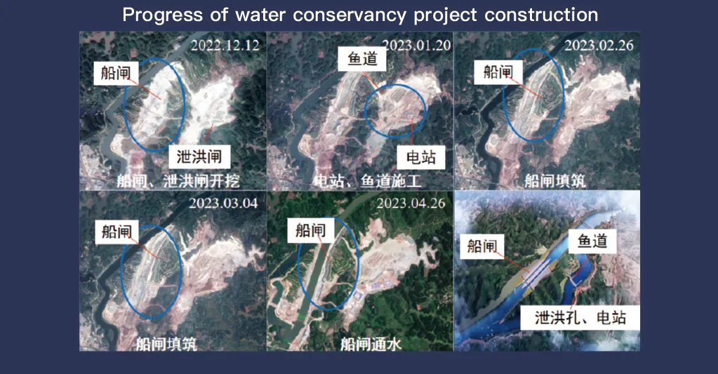
Ang Jilin-1 satellite system, nga nailhan tungod sa iyang bug-os nga coverage sa remote sensing data ug taas nga revisit capability, adunay importante nga papel sa pagmonitor ug pagdumala sa water conservancy facilities. Ang advanced nga teknolohiya sa imaging nagtugot sa taas nga resolusyon, real-time nga obserbasyon sa imprastraktura sama sa mga dam, reservoir, sistema sa irigasyon, ug mga embankment sa suba, nga naghatag ug mahinungdanong datos alang sa pagsubay sa pag-uswag sa konstruksyon, structural integrity assessment, ug early risk detection.
Uban sa iyang taas nga frequency revisit abilidad, Jilin-1 mahimo padayon nga pagkuha ug update sa mga hulagway sa target nga mga lokasyon, pagsiguro sa tukma sa panahon nga detection sa mga kausaban sa lebel sa tubig, yuta kalig-on, ug mga potensyal nga structural kahuyang. Kini nga kapabilidad ilabinang bililhon alang sa paglikay sa katalagman, tungod kay kini makahimo sa mga awtoridad sa pag-ila sa mga risgo sama sa pagdahili sa yuta, dam erosion, ug baha sa dili pa kini modako.
Moreover, the satellite’s multi-spectral and high-resolution imaging enhances the ability to monitor environmental conditions around water conservancy projects, such as vegetation cover, sedimentation, and water pollution levels. This data supports decision-making for sustainable water resource management and climate adaptation strategies.
By integrating Jilin-1 remote sensing data with geographic information systems (GIS) and artificial intelligence, real-time monitoring and predictive analysis can be further enhanced, improving response efficiency and safety measures. The satellite’s capability to provide accurate and timely data reduces reliance on ground inspections, lowering operational costs and improving the overall resilience of water conservancy infrastructure. Thus, Jilin-1 serves as a powerful tool for governments, environmental agencies, and engineering firms to ensure the safety and efficiency of water-related projects.
