- אַפְרִיקַנִי
- אלבני
- אמהרית
- עֲרָבִית
- אַרְמֶנִי
- אזרבייג'נית
- באסקית
- בלארוסית
- בנגלית
- בוסנית
- בולגרית
- קטלאנית
- סבואנו
- סִין
- קורסיקאי
- קרואטית
- צ'כית
- דַנִי
- הוֹלַנדִי
- אַנגְלִית
- אֶסְפֵּרַנְטוֹ
- אסטונית
- פִינִית
- צָרְפָתִית
- פריזית
- גליציאנית
- גרוזינית
- גֶרמָנִיָת
- יוונית
- גוג'ראטי
- קריאולי האיטי
- האוסה
- הוואי
- עִברִית
- לֹא
- מיאו
- הוּנגָרִי
- איסלנדית
- איבו
- אינדונזית
- אִירִית
- אִיטַלְקִית
- יַפָּנִית
- ג'אוואנית
- קנאדה
- קזחית
- חמר
- רואנדה
- קוריאנית
- כּוּרדִי
- קירגיזית
- עֲבוֹדָה
- לָטִינִית
- לטבית
- ליטאית
- לוקסמבורג
- מקדונית
- מלגזית
- מלאית
- מלאיאלאם
- מלטזית
- מאורי
- מראטי
- מוֹנגוֹלִי
- מיאנמר
- נפאלית
- נורבגית
- נורבגית
- אוקסיטנית
- פשטו
- פַּרסִית
- פּוֹלָנִית
- פורטוגזית
- פנג'בי
- רומנית
- רוּסִי
- סמואנית
- גאלית סקוטית
- סרבית
- אַנגְלִית
- שונה
- סינדהי
- סינהאלה
- סלובקית
- סלובנית
- סומלי
- סְפָרַדִית
- סונדני
- סוואהילית
- שוודית
- טאגלוג
- טג'יקית
- טמילית
- טטרית
- טלוגו
- תאילנדית
- טוּרקִית
- טורקמנית
- אוקראינית
- אורדו
- אויגורי
- אוזבקית
- וייטנאמית
- וולשית
- עֶזרָה
- אִידִישׁ
- יורובה
- זולו
מוצרים ושירותים לחיסכון במים
פָּרָמֶטֶר
|
Digital twin river basin standardized data base plate |
Water regulation |
|
DOM Data Backboard |
Establishment, revision and updating of reservoir capacity curve |
|
DEM/DSM Data Baseboard |
Irrigation area monitoring and water consumption calculation by remote sensing |
|
Flood and drought disaster monitoring services |
פָּרָמֶטֶר
|
River basin flood control project construction monitoring |
River and lake supervision (river and lake chief system management) |
|
Situation of Reservoir construction |
River and lake sand mining planning |
|
Safety of dam and reservoir bank |
River and lake remote sensing feature interpretation |
|
The construction of flood storage area |
Investigation of prominent problems hindering river flood flow |
|
River channels and beware of construction |
Planning for the protection of key river banks and shorelines |
|
|
"Normalize and standardize" the four disordered areas in Qing Dynasty |
|
|
The boundary data of shoreline spatial control of river and lake management waters are dynamically updated |
פָּרָמֶטֶר
|
Soil and water conservation supervision |
Supervision of water environment and water ecology |
|
Soil and Water Conservation |
Bloom monitoring |
|
Disturbance supervision |
Outfall monitoring |
|
Cage fish culture |
|
Marine regulation |
|
|
Coastlines, reefs and beaches monitoring |
|
|
Fishery resources Monitoring |
|
|
Enteromorpha and red tide monitoring |
|
|
Marine Disaster Warning
|
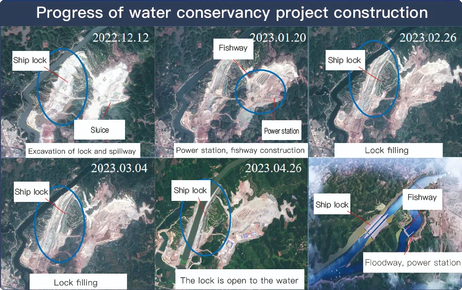
Application Of Monitoring The Construction Of Water Conservancy Facilities
For the full coverage of remote sensing data of Jilin-1 satellite and high revisit ability, it can timely monitor the construction of water conservancy facilities, dam and reservoir bank safety, flood storage area construction, river and guard construction, etc., assist the water conservancy department in the construction and management of water conservancy projects, improve the construction quality of water conservancy projects, and comprehensively understand the progress of the project.
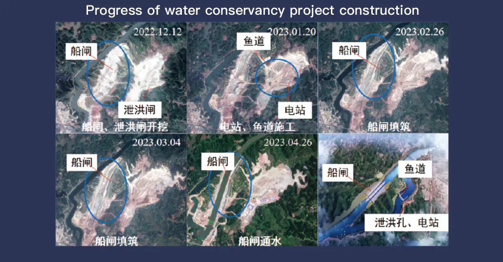
מערכת הלוויין Jilin-1, הידועה בכיסוי מלא של נתוני חישה מרחוק ויכולת ביקור חוזר גבוהה, ממלאת תפקיד מכריע בניטור וניהול מתקני שימור מים. טכנולוגיית ההדמיה המתקדמת שלה מאפשרת תצפית בזמן אמת ברזולוציה גבוהה של תשתיות כגון סכרים, מאגרים, מערכות השקיה וסוללות נהרות, ומספקת נתונים חיוניים למעקב אחר התקדמות הבנייה, הערכת תקינות מבנית וגילוי סיכונים מוקדם.
עם יכולת הביקור מחדש בתדירות הגבוהה שלו, Jilin-1 יכול לצלם ולעדכן תמונות של מיקומי יעד באופן רציף, מה שמבטיח זיהוי בזמן של שינויים במפלסי המים, יציבות הקרקע וחולשות מבניות אפשריות. יכולת זו חשובה במיוחד למניעת אסונות, שכן היא מאפשרת לרשויות לזהות סיכונים כגון מפולות, שחיקת סכר ואיומי שיטפונות לפני הסלמה.
Moreover, the satellite’s multi-spectral and high-resolution imaging enhances the ability to monitor environmental conditions around water conservancy projects, such as vegetation cover, sedimentation, and water pollution levels. This data supports decision-making for sustainable water resource management and climate adaptation strategies.
By integrating Jilin-1 remote sensing data with geographic information systems (GIS) and artificial intelligence, real-time monitoring and predictive analysis can be further enhanced, improving response efficiency and safety measures. The satellite’s capability to provide accurate and timely data reduces reliance on ground inspections, lowering operational costs and improving the overall resilience of water conservancy infrastructure. Thus, Jilin-1 serves as a powerful tool for governments, environmental agencies, and engineering firms to ensure the safety and efficiency of water-related projects.
