- الأفريقي
- الألبانية
- الأمهرية
- عربي
- الأرمنية
- أذربيجاني
- الباسكية
- البيلاروسية
- البنغالية
- البوسنية
- البلغارية
- الكاتالونية
- سيبوانو
- الصين
- كورسيكي
- الكرواتية
- التشيكية
- دانماركي
- هولندي
- إنجليزي
- الإسبرانتو
- الإستونية
- الفنلندية
- فرنسي
- الفريزية
- الجاليكية
- جورجي
- الألمانية
- اليونانية
- الغوجاراتية
- الكريولية الهايتية
- الهاوسا
- هاواي
- العبرية
- لا
- مياو
- المجرية
- الأيسلندية
- إيجبو
- اللغة الإندونيسية
- ايرلندي
- ايطالي
- اليابانية
- الجاوية
- كانادا
- الكازاخستانية
- الخميرية
- رواندية
- كوري
- كردي
- قيرغيزستان
- تَعَب
- اللاتينية
- اللاتفية
- الليتوانية
- اللوكسمبورغية
- المقدونية
- اللغة الملغاشية
- الملايو
- المالايالامية
- المالطية
- الماوري
- الماراثى
- المنغولية
- ميانمار
- النيبالية
- النرويجية
- النرويجية
- أوكيتاني
- البشتونية
- الفارسية
- بولندي
- البرتغالية
- البنجابية
- روماني
- الروسية
- ساموا
- الغيلية الاسكتلندية
- الصربية
- إنجليزي
- شونا
- السندية
- السنهالية
- السلوفاكية
- السلوفينية
- الصومالية
- الأسبانية
- اللغة السوندانية
- السواحلية
- السويدية
- التاغالوغية
- الطاجيكية
- التاميلية
- التتار
- التيلجو
- تايلاندي
- اللغة التركية
- تركمان
- الأوكرانية
- الأردية
- الأويغور
- الأوزبكية
- الفيتنامية
- الويلزية
- يساعد
- اليديشية
- اليوروبا
- الزولو
منتجات وخدمات الحفاظ على المياه
المعلمة
|
Digital twin river basin standardized data base plate |
Water regulation |
|
DOM Data Backboard |
Establishment, revision and updating of reservoir capacity curve |
|
DEM/DSM Data Baseboard |
Irrigation area monitoring and water consumption calculation by remote sensing |
|
Flood and drought disaster monitoring services |
المعلمة
|
River basin flood control project construction monitoring |
River and lake supervision (river and lake chief system management) |
|
Situation of Reservoir construction |
River and lake sand mining planning |
|
Safety of dam and reservoir bank |
River and lake remote sensing feature interpretation |
|
The construction of flood storage area |
Investigation of prominent problems hindering river flood flow |
|
River channels and beware of construction |
Planning for the protection of key river banks and shorelines |
|
|
"Normalize and standardize" the four disordered areas in Qing Dynasty |
|
|
The boundary data of shoreline spatial control of river and lake management waters are dynamically updated |
المعلمة
|
Soil and water conservation supervision |
Supervision of water environment and water ecology |
|
Soil and Water Conservation |
Bloom monitoring |
|
Disturbance supervision |
Outfall monitoring |
|
Cage fish culture |
|
Marine regulation |
|
|
Coastlines, reefs and beaches monitoring |
|
|
Fishery resources Monitoring |
|
|
Enteromorpha and red tide monitoring |
|
|
Marine Disaster Warning
|
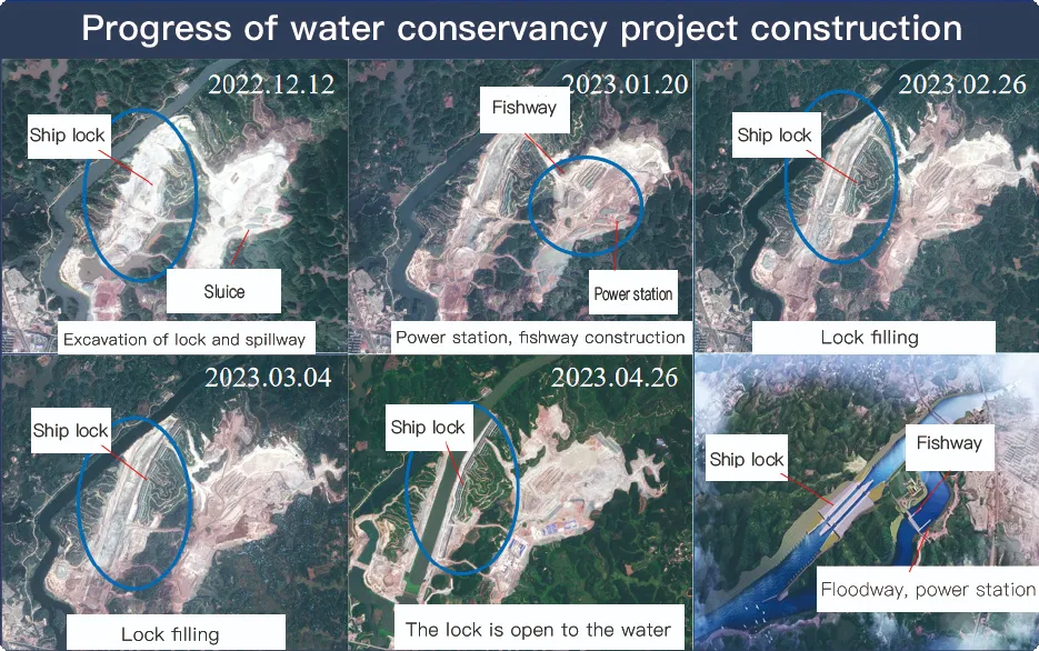
Application Of Monitoring The Construction Of Water Conservancy Facilities
For the full coverage of remote sensing data of Jilin-1 satellite and high revisit ability, it can timely monitor the construction of water conservancy facilities, dam and reservoir bank safety, flood storage area construction, river and guard construction, etc., assist the water conservancy department in the construction and management of water conservancy projects, improve the construction quality of water conservancy projects, and comprehensively understand the progress of the project.
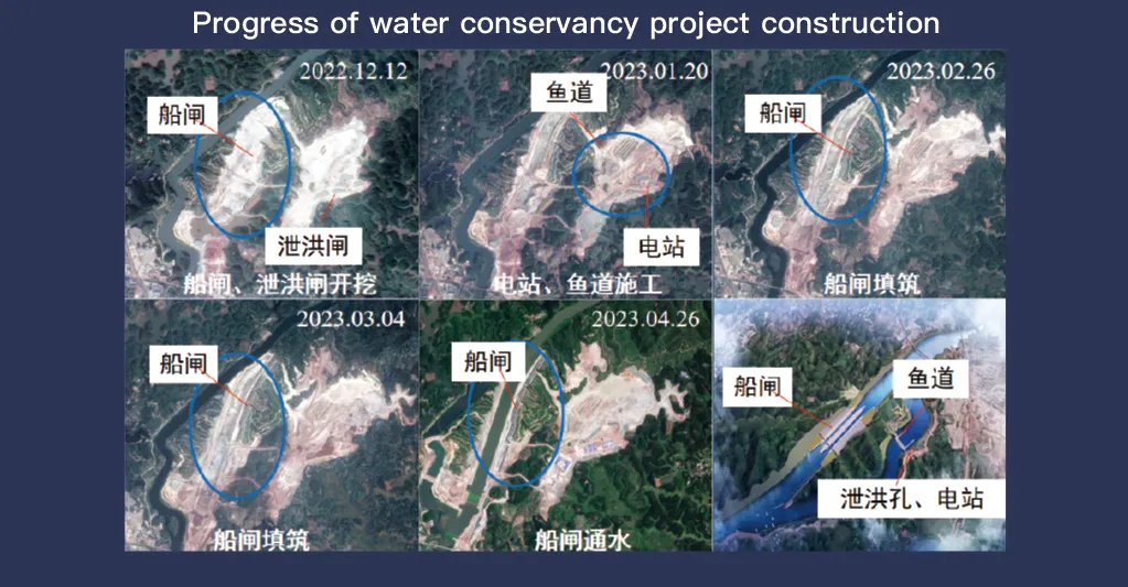
يتميز نظام جيلين-1 للأقمار الصناعية بتغطيته الشاملة لبيانات الاستشعار عن بُعد وقدرته العالية على إعادة الزيارة، ويلعب دورًا محوريًا في رصد وإدارة مرافق الحفاظ على المياه. تتيح تقنية التصوير المتطورة فيه مراقبة عالية الدقة وفي الوقت الفعلي للبنية التحتية، مثل السدود والخزانات وأنظمة الري وجسور الأنهار، مما يوفر بيانات أساسية لتتبع تقدم أعمال البناء، وتقييم سلامة الهياكل الإنشائية، والكشف المبكر عن المخاطر.
بفضل قدرته على إعادة الزيارة عالية التردد، يستطيع جيلين-1 التقاط صور للمواقع المستهدفة وتحديثها باستمرار، مما يضمن الكشف الفوري عن التغيرات في منسوب المياه، واستقرار التربة، ونقاط الضعف الهيكلية المحتملة. تُعد هذه القدرة قيّمة بشكل خاص للوقاية من الكوارث، حيث تُمكّن السلطات من تحديد مخاطر مثل الانهيارات الأرضية، وتآكل السدود، والفيضانات قبل تفاقمها.
Moreover, the satellite’s multi-spectral and high-resolution imaging enhances the ability to monitor environmental conditions around water conservancy projects, such as vegetation cover, sedimentation, and water pollution levels. This data supports decision-making for sustainable water resource management and climate adaptation strategies.
By integrating Jilin-1 remote sensing data with geographic information systems (GIS) and artificial intelligence, real-time monitoring and predictive analysis can be further enhanced, improving response efficiency and safety measures. The satellite’s capability to provide accurate and timely data reduces reliance on ground inspections, lowering operational costs and improving the overall resilience of water conservancy infrastructure. Thus, Jilin-1 serves as a powerful tool for governments, environmental agencies, and engineering firms to ensure the safety and efficiency of water-related projects.
