- Afrikanac
- Albanac
- amharski
- arapski
- Jermenski
- Azerbejdžanski
- Basque
- bjeloruski
- bengalski
- bosanski
- bugarski
- katalonski
- Cebuano
- Kina
- Korzikanac
- hrvatski
- češki
- danski
- Dutch
- engleski
- esperanto
- estonski
- Finski
- francuski
- Frizijski
- galicijski
- Gruzijski
- njemački
- grčki
- gudžarati
- haićanski kreolski
- Hausa
- hawaiian
- hebrejski
- br
- Miao
- Mađarski
- islandski
- igbo
- indonezijski
- irski
- talijanski
- Japanski
- Javanese
- kanada
- kazakh
- kmerski
- Ruandski
- Korean
- kurdski
- kirgiski
- Rad
- Latinski
- Latvian
- litvanski
- Luksemburški
- makedonski
- malgaški
- malajski
- malajalam
- Maltezer
- Maori
- Marathi
- mongolski
- Myanmar
- nepalski
- norveški
- norveški
- Occitan
- Pashto
- perzijski
- Poljski
- portugalski
- Punjabi
- rumunski
- ruski
- Samoan
- Scottish Gaelic
- srpski
- engleski
- Šona
- Sindhi
- Sinhala
- slovački
- slovenački
- somalijski
- španjolski
- sundanski
- svahili
- švedski
- Tagalog
- Tajik
- tamilski
- Tatar
- telugu
- tajlandski
- turski
- Turkmen
- ukrajinski
- Urdu
- Ujgur
- Uzbek
- Vijetnamski
- velški
- Upomoć
- jidiš
- Yoruba
- Zulu
Proizvodi i usluge za očuvanje vode
parametar
|
Digital twin river basin standardized data base plate |
Water regulation |
|
DOM Data Backboard |
Establishment, revision and updating of reservoir capacity curve |
|
DEM/DSM Data Baseboard |
Irrigation area monitoring and water consumption calculation by remote sensing |
|
Flood and drought disaster monitoring services |
parametar
|
River basin flood control project construction monitoring |
River and lake supervision (river and lake chief system management) |
|
Situation of Reservoir construction |
River and lake sand mining planning |
|
Safety of dam and reservoir bank |
River and lake remote sensing feature interpretation |
|
The construction of flood storage area |
Investigation of prominent problems hindering river flood flow |
|
River channels and beware of construction |
Planning for the protection of key river banks and shorelines |
|
|
"Normalize and standardize" the four disordered areas in Qing Dynasty |
|
|
The boundary data of shoreline spatial control of river and lake management waters are dynamically updated |
parametar
|
Soil and water conservation supervision |
Supervision of water environment and water ecology |
|
Soil and Water Conservation |
Bloom monitoring |
|
Disturbance supervision |
Outfall monitoring |
|
Cage fish culture |
|
Marine regulation |
|
|
Coastlines, reefs and beaches monitoring |
|
|
Fishery resources Monitoring |
|
|
Enteromorpha and red tide monitoring |
|
|
Marine Disaster Warning
|
Application Of Monitoring The Construction Of Water Conservancy Facilities
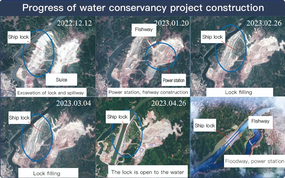
For the full coverage of remote sensing data of Jilin-1 satellite and high revisit ability, it can timely monitor the construction of water conservancy facilities, dam and reservoir bank safety, flood storage area construction, river and guard construction, etc., assist the water conservancy department in the construction and management of water conservancy projects, improve the construction quality of water conservancy projects, and comprehensively understand the progress of the project.
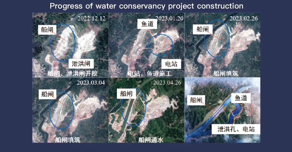
Satelitski sistem Jilin-1, poznat po svojoj potpunoj pokrivenosti podataka daljinskog istraživanja i visokoj sposobnosti ponovne posjete, igra ključnu ulogu u praćenju i upravljanju objektima za zaštitu voda. Njegova napredna tehnologija snimanja omogućava posmatranje infrastrukture u realnom vremenu visoke rezolucije kao što su brane, rezervoari, sistemi za navodnjavanje i rečni nasipi, obezbeđujući osnovne podatke za praćenje napretka izgradnje, procenu integriteta konstrukcije i rano otkrivanje rizika.
Sa svojom visokofrekventnom sposobnošću ponovnog pregleda, Jilin-1 može kontinuirano snimati i ažurirati slike ciljanih lokacija, osiguravajući pravovremeno otkrivanje promjena u nivou vode, stabilnosti tla i potencijalnih strukturalnih slabosti. Ova sposobnost je posebno vrijedna za prevenciju katastrofa, jer omogućava vlastima da identifikuju rizike kao što su klizišta, erozija brana i prijetnje od poplava prije nego što eskaliraju.
Moreover, the satellite’s multi-spectral and high-resolution imaging enhances the ability to monitor environmental conditions around water conservancy projects, such as vegetation cover, sedimentation, and water pollution levels. This data supports decision-making for sustainable water resource management and climate adaptation strategies.
By integrating Jilin-1 remote sensing data with geographic information systems (GIS) and artificial intelligence, real-time monitoring and predictive analysis can be further enhanced, improving response efficiency and safety measures. The satellite’s capability to provide accurate and timely data reduces reliance on ground inspections, lowering operational costs and improving the overall resilience of water conservancy infrastructure. Thus, Jilin-1 serves as a powerful tool for governments, environmental agencies, and engineering firms to ensure the safety and efficiency of water-related projects.
