- アフリカ
- アルバニア語
- アムハラ語
- アラビア語
- アルメニア語
- アゼルバイジャン語
- バスク語
- ベラルーシ語
- ベンガル語
- ボスニア語
- ブルガリア語
- カタロニア語
- セブアノ語
- 中国
- コルシカ
- クロアチア語
- チェコ語
- デンマーク語
- オランダ語
- 英語
- エスペラント
- エストニア語
- フィンランド語
- フランス語
- フリジア語
- ガリシア語
- グルジア語
- ドイツ語
- ギリシャ語
- グジャラート語
- ハイチ語
- ハウサ語
- ハワイアン
- ヘブライ語
- いいえ
- ミャオ族
- ハンガリー語
- アイスランド語
- イボ語
- インドネシア語
- アイルランド人
- イタリア語
- 日本語
- ジャワ語
- カンナダ語
- カザフ語
- クメール語
- ルワンダ
- 韓国語
- クルド
- キルギス語
- 労働
- ラテン
- ラトビア語
- リトアニア語
- ルクセンブルク語
- マケドニア語
- マダガスカル語
- マレー語
- マラヤーラム語
- マルタ語
- マオリ語
- マラーティー語
- モンゴル語
- ミャンマー
- ネパール語
- ノルウェー語
- ノルウェー語
- オック語
- パシュトゥー語
- ペルシャ語
- 研磨
- ポルトガル語
- パンジャブ語
- ルーマニア語
- ロシア
- サモア語
- スコットランド・ゲール語
- セルビア語
- 英語
- ショナ語
- シンディー語
- シンハラ語
- スロバキア語
- スロベニア語
- ソマリア
- スペイン語
- スンダ語
- スワヒリ語
- スウェーデン語
- タガログ語
- タジク語
- タミル語
- タタール語
- テルグ語
- タイ語
- トルコ語
- トルクメン語
- ウクライナ語
- ウルドゥー語
- ウイグル
- ウズベク語
- ベトナム語
- ウェールズ語
- ヘルプ
- イディッシュ語
- ヨルバ語
- ズールー語
パラメータ
|
力 |
石炭 |
|
送電ネットワークの特徴抽出 |
石炭資源の調査と評価 |
|
送電網プロジェクト進捗管理 |
鉱山工学進捗検査 |
|
送電網の環境検査 |
鉱山地域の環境モニタリング |
パラメータ
|
石油とガス |
新エネルギー |
|
石油・ガス資源探査 |
太陽光発電パネルのリモートセンシング識別 |
|
パイプラインレイアウト調査 |
太陽光発電ポテンシャルの推定 |
|
石油土木工事の監督 |
原子力施設建設プロセスの監視 |
|
石油埋蔵量の検出 |
風力発電所の検査 |
|
ガスパイプラインの漏れ検出 |
新エネルギー施設周辺の環境モニタリング |
|
ファイナンス |
|
|
農業信用、農業保険など |
|
|
不動産およびその他のプロジェクトクレジット |
|
|
産業および新エネルギー建設クレジット |
電力リモートセンシング監視アプリケーション
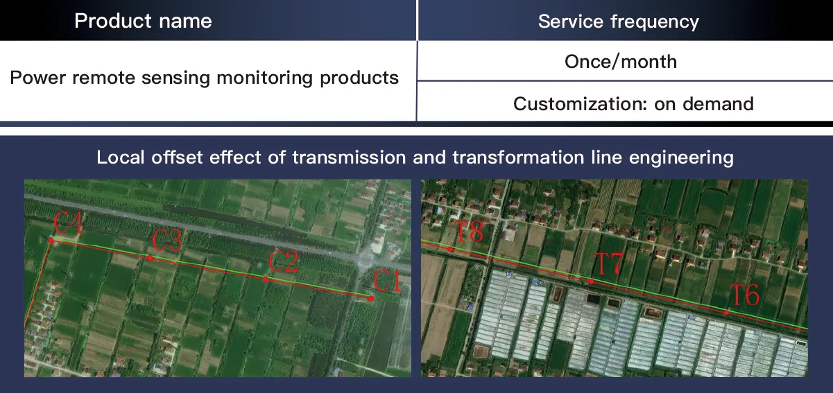
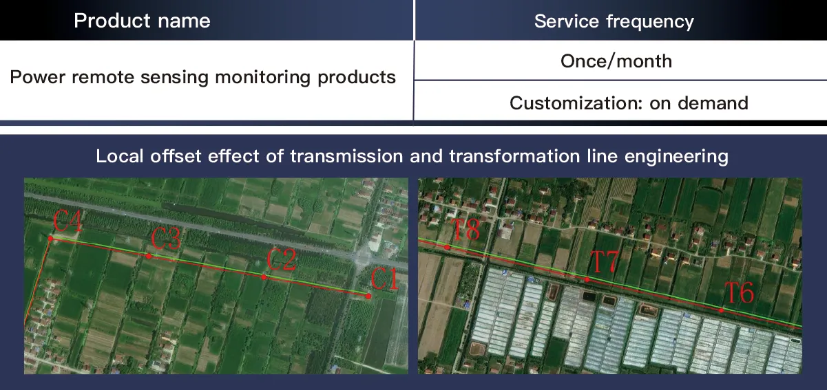
電力網会社と電力管理部門は、送電線周囲300メートルの厳格な管理、500メートルの予防管理、1キロメートルの総合調査などの検査要件を考慮して、衛星リモートセンシング監視を通じて、建設鉄塔の位置オフセットと妨害範囲、生態変化評価、送変電線オフセット、送変電プロジェクト両側の建物情報と温室マルチング作業、道路復旧進捗状況などを持続的に監視し、電力検査部門が送電線の総合的な管理を実現するのを支援します。
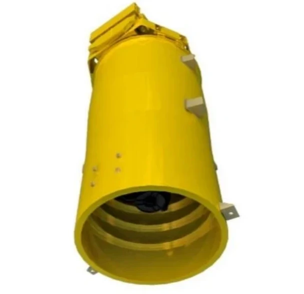
The Changguang TW Series UAV is a high-performance unmanned aerial vehicle designed for energy finance applications, including asset monitoring, pipeline inspection, and infrastructure surveillance. It features a fixed-wing design with advanced aerodynamics, allowing for long-endurance flights of up to 20 hours and an operating altitude of 8,000 meters. Equipped with high-resolution EO/IR cameras, LiDAR, and real-time data transmission capabilities, it ensures accurate and efficient data collection for risk assessment and asset management. With a cruising speed of 100–150 km/h and modular payload configurations, the UAV adapts to various mission requirements, providing cost-effective solutions for large-scale energy sector monitoring. Its autonomous and remote-control capabilities reduce human intervention, enhancing operational efficiency and safety. The TW Series excels in high-altitude operations, offering stable performance in complex environments, making it an ideal solution for financial risk evaluation, energy asset protection, and remote infrastructure management.
High-Resolution Satellite Remote Sensing Data Powers Energy-Finance Monitoring with Real-Time Data Architecture
In the digital era of energy finance, high-resolution satellite remote sensing has emerged as a cornerstone for intelligent risk management. SpaceNavi’s real-time data architecture integrates high-resolution remote sensing images and advanced data acquisition systems to transform satellite remote sensing data into actionable insights for energy asset monitoring and financial risk assessment.
Real-Time Data Acquisition: Solving the "How" of Satellite Imagery
At the core of our solution lies a robust data acquisition system that addresses the critical question: How to get real-time satellite images? By leveraging constellations like Jilin-1 (0.5–2m resolution) and Sentinel-2, we enable:
Hourly revisit capabilities for critical energy infrastructure, from oil pipelines to solar farms.
Capture of multi-spectral, thermal, and NIR bands—key types of remote sensing images essential for energy analysis.
Ground-based IoT sensors complement satellite data, ensuring 97% accuracy in real-time remote sensing data collection.
Image Analysis: From Pixels to Predictive Intelligence
1. Multi-Type Remote Sensing Integration
We process 10 TB+ of weekly imagery, differentiating types of remote sensing images to:
Use thermal infrared imagery for pipeline leak detection.
Employ NIR bands to monitor vegetation encroachment on power lines.
Rely on high-resolution visible light remote sensing satellite images for detailed asset inspections.
2. AI-Driven Analytics
Our image analysis suite uses machine learning to:
Automatically detect construction deviations in transmission projects (300m precision).
Predict equipment degradation by analyzing structural changes in satellite imagery.
Generate energy asset risk scores with 89% accuracy in identifying high-risk zones.
The Technical Framework in Action
Satellite Data Fusion: Integrates satellite remote sensing data with financial transaction records to align project progress with investment milestones.
Real-Time Dashboard: Visualizes remote sensing data alongside energy market trends for dynamic risk adjustment.
Historical Archive: Stores 5+ years of high-resolution remote sensing images for long-term asset performance modeling.
The Future of Energy-Finance Tech
SpaceNavi’s framework proves that high-resolution satellite remote sensing, paired with real-time data architecture, enables precise digital twin creation for energy assets. By closing the loop from data acquisition to predictive modeling, we empower stakeholders to manage energy investments with unprecedented foresight—bridging the gap between remote sensing technology and financial decision-making.
Full-Cycle High-Resolution Remote Sensing Monitoring for Transmission Projects – Data Acquisition and Offset Analysis Framework
In the construction and maintenance of power transmission projects, precise monitoring of offset effects and real-time status is critical to ensure grid safety. SpaceNavi’s technical framework integrates high-resolution remote sensing images and advanced image analysis to establish a full-cycle monitoring system, enabling end-to-end management of transmission projects from construction to operation.
Real-Time Satellite Image Acquisition: Solving the Core Challenge
The data acquisition system addresses the key question: How to get real-time satellite images for transmission lines? By leveraging Jilin-1 constellations (0.5–2m resolution) and multi-spectral satellites, we enable:
Hourly revisit capabilities for critical sections, capturing remote sensing satellite images of construction sites.
Collection of visible, NIR, and thermal bands—key types of remote sensing images for infrastructure analysis.
Ground-based LiDAR and IoT sensors complement satellite data, forming a 360° remote sensing data acquisition network with 98% accuracy.
Multi-Type Image Analysis for Offset Effect Detection
1. Spectral Feature Extraction
We process 8TB/week of satellite remote sensing data, differentiating types of remote sensing images to:
Use thermal imagery to detect heat anomalies in transformers.
Employ NIR bands to monitor vegetation encroachment on transmission corridors.
Rely on high-resolution visible light images for millimeter-level offset measurements.
2. AI-Driven Offset Modeling
The image analysis suite uses machine learning to:
Automatically identify construction deviations (300m precision) by comparing planned vs. actual alignment.
Predict soil settlement risks through multi-temporal image correlation, with 92% accuracy in offset trend forecasting.
Generate real-time offset early-warning maps, reducing manual inspections by 70%.
Technical Path Integration: From Data to Decision
Satellite-Data Fusion: Integrate satellite remote sensing data with BIM models to visualize offset effects in 3D.
Real-Time Dashboard: Display remote sensing data alongside construction schedules for dynamic progress tracking.
Historical Archive: Store 10+ years of high-resolution remote sensing images for long-term structural health assessment.
Future of Transmission Monitoring
SpaceNavi’s framework proves that full-cycle remote sensing, by integrating real-time image acquisition and offset effect analysis, transforms traditional project management into data-driven precision governance. By embedding high-resolution remote sensing images and intelligent image analysis into every project phase, we ensure transmission networks are built and operated with unprecedented accuracy, safeguarding energy infrastructure for decades to come.
