- Afrikaans
- Albanian
- Amharic
- Arabic
- Armenian
- Azerbaijani
- Basque
- Belarusian
- Bengali
- Bosnian
- Bulgarian
- Catalan
- Cebuano
- China
- Corsican
- Croatian
- Czech
- Danish
- Dutch
- English
- Esperanto
- Estonian
- Finnish
- French
- Frisian
- Galician
- Georgian
- German
- Greek
- Gujarati
- Haitian Creole
- hausa
- hawaiian
- Hebrew
- Hindi
- Miao
- Hungarian
- Icelandic
- igbo
- Indonesian
- irish
- Italian
- Japanese
- Javanese
- Kannada
- kazakh
- Khmer
- Rwandese
- Korean
- Kurdish
- Kyrgyz
- Lao
- Latin
- Latvian
- Lithuanian
- Luxembourgish
- Macedonian
- Malgashi
- Malay
- Malayalam
- Maltese
- Maori
- Marathi
- Mongolian
- Myanmar
- Nepali
- Norwegian
- Norwegian
- Occitan
- Pashto
- Persian
- Polish
- Portuguese
- Punjabi
- Romanian
- Russian
- Samoan
- Scottish Gaelic
- Serbian
- Sesotho
- Shona
- Sindhi
- Sinhala
- Slovak
- Slovenian
- Somali
- Spanish
- Sundanese
- Swahili
- Swedish
- Tagalog
- Tajik
- Tamil
- Tatar
- Telugu
- Thai
- Turkish
- Turkmen
- Ukrainian
- Urdu
- Uighur
- Uzbek
- Vietnamese
- Welsh
- Bantu
- Yiddish
- Yoruba
- Zulu
Warning: Undefined array key "array_term_id" in /home/www/wwwroot/HTML/www.exportstart.com/wp-content/themes/1371/header-lBanner.php on line 78
Warning: Trying to access array offset on value of type null in /home/www/wwwroot/HTML/www.exportstart.com/wp-content/themes/1371/header-lBanner.php on line 78
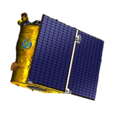
GF Series Satellites 0.75m - SpaceNavi|High-Res Imaging&Remote Sensing
SpaceNavi Co., Ltd., a leading innovator in satellite technology, has introduced the GF Series Satellites, a groundbreaking line of optical remote sensing satellites with a 0.75m resolution. These satellites represent the latest advancements in remote sensing satellites technology, offering unparalleled clarity and precision for a wide range of applications. This article explores the features, advantages, technical specifications, and applications of the GF Series, along with insights into the company behind this innovation.
Product Overview
The GF Series Satellites are the result of independent research and development by SpaceNavi Co., Ltd.. Designed to meet the growing demand for high-resolution imaging, these satellites are equipped with cutting-edge optical systems that deliver detailed imagery for geospatial analysis, environmental monitoring, and disaster management. The product is available at SpaceNavi's official website.


Key Features and Advantages
The GF Series Satellites stand out due to their advanced features and benefits:
- High-Resolution Imaging: With a 0.75m resolution, these satellites provide exceptionally detailed images, enabling precise analysis of terrain, urban development, and natural resources.
- Independent R&D: Developed entirely by SpaceNavi Co., Ltd., the GF Series reflects the company's commitment to innovation and self-reliance in satellite technology.
- Multi-Spectral Capabilities: Equipped with multi-spectral sensors, the satellites capture data across multiple wavelengths, enhancing their utility in environmental monitoring and agricultural analysis.
- Real-Time Data Transmission: The satellites support rapid data transmission, ensuring timely access to critical information for decision-makers.
Technical Specifications
| Specification | Details |
|---|---|
| Resolution | 0.75 meters |
| Sensor Type | Optical Remote Sensing |
| Orbit Type | Low Earth Orbit (LEO) |
| Revisit Time | Varies based on mission requirements |
| Data Transmission Rate | High-speed downlink for real-time applications |
| Power System | Solar panels with energy storage capabilities |
Applications and Use Cases
The GF Series Satellites are designed to serve a variety of industries and sectors:
- Environmental Monitoring: Track deforestation, urban sprawl, and climate change impacts with high-resolution imagery.
- Disaster Management: Provide real-time data for flood mapping, earthquake assessment, and wildfire monitoring, aiding in emergency response efforts.
- AgriTech: Support precision agriculture by analyzing crop health, soil conditions, and irrigation efficiency.
- Urban Planning: Assist in city development and infrastructure projects with accurate land-use data.
- Defense and Security: Enhance situational awareness for military and intelligence operations.
Company Background: SpaceNavi Co., Ltd.
Based in Ningbo, China, SpaceNavi Co., Ltd. (officially known as Ningbo Mingji International Trade Co., Ltd.) is a pioneer in satellite technology and remote sensing solutions. The company has established itself as a leader in developing advanced satellite communication services and artificial intelligence satellite systems. With a focus on innovation and quality, SpaceNavi has become a trusted partner for governments, businesses, and research institutions worldwide.
For more information about the company, visit SpaceNavi's official website.
Industry Impact and Future Prospects
The introduction of the GF Series Satellites marks a significant milestone in the satellite communication industry. As the demand for high-resolution data continues to grow, these satellites are poised to play a critical role in shaping the future of remote sensing satellites. According to the National Institute of Standards and Technology (NIST), advancements in satellite technology are essential for improving measurement accuracy and supporting innovation in various fields [1].
Conclusion
The GF Series Satellites by SpaceNavi Co., Ltd. represent a leap forward in optical remote sensing technology. With their 0.75m resolution, advanced features, and diverse applications, these satellites are set to redefine the possibilities of remote sensing. As the company continues to innovate, the GF Series is expected to become a cornerstone of modern geospatial analysis and environmental monitoring.
References
[1] National Institute of Standards and Technology. (n.d.). What We Do. Retrieved from https://www.nist.gov


