- Afrikaans
- Albanian
- Amharic
- Arabic
- Armenian
- Azerbaijani
- Basque
- Belarusian
- Bengali
- Bosnian
- Bulgarian
- Catalan
- Cebuano
- China
- Corsican
- Croatian
- Czech
- Danish
- Dutch
- English
- Esperanto
- Estonian
- Finnish
- French
- Frisian
- Galician
- Georgian
- German
- Greek
- Gujarati
- Haitian Creole
- hausa
- hawaiian
- Hebrew
- Hindi
- Miao
- Hungarian
- Icelandic
- igbo
- Indonesian
- irish
- Italian
- Japanese
- Javanese
- Kannada
- kazakh
- Khmer
- Rwandese
- Korean
- Kurdish
- Kyrgyz
- Lao
- Latin
- Latvian
- Lithuanian
- Luxembourgish
- Macedonian
- Malgashi
- Malay
- Malayalam
- Maltese
- Maori
- Marathi
- Mongolian
- Myanmar
- Nepali
- Norwegian
- Norwegian
- Occitan
- Pashto
- Persian
- Polish
- Portuguese
- Punjabi
- Romanian
- Russian
- Samoan
- Scottish Gaelic
- Serbian
- Sesotho
- Shona
- Sindhi
- Sinhala
- Slovak
- Slovenian
- Somali
- Spanish
- Sundanese
- Swahili
- Swedish
- Tagalog
- Tajik
- Tamil
- Tatar
- Telugu
- Thai
- Turkish
- Turkmen
- Ukrainian
- Urdu
- Uighur
- Uzbek
- Vietnamese
- Welsh
- Bantu
- Yiddish
- Yoruba
- Zulu
Warning: Undefined array key "array_term_id" in /home/www/wwwroot/HTML/www.exportstart.com/wp-content/themes/1371/header-lBanner.php on line 78
Warning: Trying to access array offset on value of type null in /home/www/wwwroot/HTML/www.exportstart.com/wp-content/themes/1371/header-lBanner.php on line 78
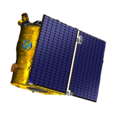
GF Series Satellites 0.75m Resolution-SpaceNavi Co.,Ltd.|High-Resolution Imaging&AI-Enhanced Processing
SpaceNavi Co., Ltd. (formerly Ningbo Mingji International Trade Co., Ltd.) has introduced the GF Series Satellites, a groundbreaking advancement in optical remote sensing technology. These satellites offer a remarkable resolution of 0.75 meters, enabling unprecedented precision in Earth observation. This article explores the technical specifications, applications, and significance of the GF Series within the broader context of satellite technology and artificial intelligence (AI) integration.


Product Overview
The GF Series satellites represent a significant leap in optical remote sensing capabilities. Developed by SpaceNavi Co., Ltd., these satellites are designed to provide high-resolution imagery for a wide range of applications, from environmental monitoring to urban planning. The 0.75m resolution allows for detailed analysis of terrestrial features, making them a valuable tool for governments, researchers, and industries.
Key Features and Technical Specifications
The GF Series satellites are equipped with advanced optical sensors and AI-driven processing systems. Below is a detailed specification table:
| Specification | Details |
|---|---|
| Resolution | 0.75 meters |
| Sensor Type | Optical Remote Sensing |
| Orbit Type | Low Earth Orbit (LEO) |
| Revisit Time | 1-3 days |
| Data Processing | AI-Enhanced |
| Communication | Satellite Communication Services |
Technological Advancements
The GF Series satellites incorporate cutting-edge technology to ensure high-quality data acquisition. The optical remote sensing capability allows for the capture of detailed images in various spectral bands, enabling applications such as land cover classification and vegetation monitoring. Additionally, the integration of artificial intelligence satellite technology enhances data processing, allowing for real-time analysis and anomaly detection.
According to the National Institute of Standards and Technology (NIST), advancements in AI and machine learning have significantly impacted the field of remote sensing. The GF Series satellites leverage these technologies to improve the accuracy and efficiency of data analysis, as highlighted in NIST's research on AI-driven applications in remote sensing.
Applications and Use Cases
The versatility of the GF Series satellites makes them suitable for a wide range of applications. Some of the key use cases include:
- Environmental Monitoring: Tracking deforestation, urban expansion, and natural disasters.
- Agricultural Planning: Assessing crop health and optimizing resource allocation.
- Disaster Response: Providing real-time imagery for emergency management and relief efforts.
- Urban Development: Supporting city planning and infrastructure projects.
These applications align with the goals of satellite communication services, which aim to enhance global connectivity and data accessibility. The GF Series satellites contribute to this vision by providing reliable and high-resolution data to stakeholders worldwide.
Company Background
SpaceNavi Co., Ltd. (formerly Ningbo Mingji International Trade Co., Ltd.) has established itself as a leader in the satellite technology sector. With a focus on innovation and quality, the company has developed a range of products that cater to the growing demand for advanced remote sensing solutions. Their commitment to excellence is reflected in the design and performance of the GF Series satellites.
The company's expertise in types of remote sensing satellites and satellite communication services positions it as a key player in the industry. By leveraging its technical capabilities and market insights, SpaceNavi Co., Ltd. continues to drive advancements in satellite technology.
Industry Impact and Future Prospects
The introduction of the GF Series satellites marks a significant milestone in the remote sensing industry. With their high-resolution capabilities and AI integration, these satellites set a new standard for Earth observation. As the demand for accurate and timely data increases, the GF Series is poised to meet the challenges of modern applications.
Looking ahead, the potential for further innovation in satellite technology is vast. The integration of Starlink satellite internet and other emerging technologies could enhance the functionality of remote sensing satellites, enabling more efficient data transmission and global coverage.
Conclusion
The GF Series satellites with 0.75m resolution represent a significant advancement in optical remote sensing technology. Their combination of high-resolution imaging, AI-driven processing, and versatile applications makes them a valuable asset for various industries. As SpaceNavi Co., Ltd. continues to innovate, the GF Series is set to play a pivotal role in shaping the future of satellite technology.
References
National Institute of Standards and Technology (NIST) - Research on AI-driven applications in remote sensing.
SpaceNavi Co., Ltd. - Official website for detailed product information.
GF Series Satellites with 0.75m Resolution - Product page for the GF Series.


