- Afrikaans
- Albanian
- Amharic
- Arabic
- Armenian
- Azerbaijani
- Basque
- Belarusian
- Bengali
- Bosnian
- Bulgarian
- Catalan
- Cebuano
- China
- Corsican
- Croatian
- Czech
- Danish
- Dutch
- English
- Esperanto
- Estonian
- Finnish
- French
- Frisian
- Galician
- Georgian
- German
- Greek
- Gujarati
- Haitian Creole
- hausa
- hawaiian
- Hebrew
- Hindi
- Miao
- Hungarian
- Icelandic
- igbo
- Indonesian
- irish
- Italian
- Japanese
- Javanese
- Kannada
- kazakh
- Khmer
- Rwandese
- Korean
- Kurdish
- Kyrgyz
- Lao
- Latin
- Latvian
- Lithuanian
- Luxembourgish
- Macedonian
- Malgashi
- Malay
- Malayalam
- Maltese
- Maori
- Marathi
- Mongolian
- Myanmar
- Nepali
- Norwegian
- Norwegian
- Occitan
- Pashto
- Persian
- Polish
- Portuguese
- Punjabi
- Romanian
- Russian
- Samoan
- Scottish Gaelic
- Serbian
- Sesotho
- Shona
- Sindhi
- Sinhala
- Slovak
- Slovenian
- Somali
- Spanish
- Sundanese
- Swahili
- Swedish
- Tagalog
- Tajik
- Tamil
- Tatar
- Telugu
- Thai
- Turkish
- Turkmen
- Ukrainian
- Urdu
- Uighur
- Uzbek
- Vietnamese
- Welsh
- Bantu
- Yiddish
- Yoruba
- Zulu
Warning: Undefined array key "array_term_id" in /home/www/wwwroot/HTML/www.exportstart.com/wp-content/themes/1371/header-lBanner.php on line 78
Warning: Trying to access array offset on value of type null in /home/www/wwwroot/HTML/www.exportstart.com/wp-content/themes/1371/header-lBanner.php on line 78
Satellite Remote Sensing Data - SpaceNavi Co., Ltd. | Environmental Data, Disaster Management
SpaceNavi Co., Ltd., a leader in environmental technology, offers cutting-edge satellite monitoring systems designed to address critical ecological challenges. By leveraging satellite remote sensing data, the company provides comprehensive solutions for carbon stock estimation, air and water pollution control, and disaster management. This article explores the product's features, technical specifications, and real-world applications, supported by insights from the National Institute of Standards and Technology (NIST).

Product Overview
SpaceNavi's environmental monitoring system integrates data acquisition systems with advanced AI algorithms to deliver real-time environmental insights. The platform supports multiple applications, including forest carbon sink estimation, air pollution source tracing, and emergency response to environmental disasters. According to NIST, "precise measurements and standardized protocols are essential for effective environmental monitoring" (NIST.gov).
Key Features and Advantages
- Satellite remote sensing data: Enables large-scale environmental monitoring with high spatial resolution.
- Environmental data integration: Combines ground sensor readings with satellite imagery for accurate analysis.
- Disaster management capabilities: Provides real-time monitoring for events like forest fires and oil spills.
- Image registration: Ensures alignment of multispectral data for precise anomaly detection.
Technical Specifications
| Parameter | Description |
|---|---|
| Data Acquisition | Multi-sensor integration for real-time environmental monitoring |
| Resolution | Up to 1m spatial resolution for detailed analysis |
| Processing Speed | AI-powered algorithms for instant data interpretation |
| Compatibility | Supports integration with existing environmental management systems |
Applications in Environmental Protection
Green and Low-Carbon Development
The system excels in estimating forest carbon sink stocks, a critical component of climate change mitigation. By analyzing spectral characteristics of vegetation, SpaceNavi's technology provides accurate carbon stock assessments, aiding in the implementation of clean engineering projects. NIST emphasizes the importance of standardized measurement techniques for such applications (NIST.gov).
Blue Sky Defense
For air pollution control, the platform identifies sources of particulate matter and tracks emission trends. It supports the supervision of non-point sources of bare earth dust pollution and monitors straw incineration in agricultural areas. This aligns with NIST's work on environmental standards for air quality monitoring (NIST.gov).
Clear Water Defense Battle
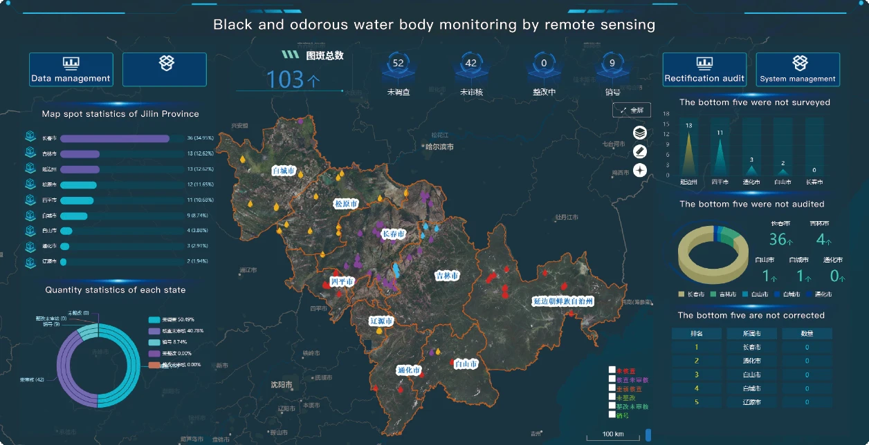
The system detects urban black and smelly water bodies by analyzing water transparency and dissolved oxygen levels. It also monitors river outlets and conducts water ecological quality inversion, contributing to the protection of aquatic ecosystems. NIST's research on water quality standards reinforces the need for such technologies (NIST.gov).
Pure Land Protection
SpaceNavi's solutions address soil pollution through black land conservation monitoring and rural water body analysis. The platform's ability to detect contaminants in real time supports the implementation of ecological zoning control strategies.
Emergency Response
During environmental disasters, the system provides critical data for forest fire monitoring, flood response, and oil spill tracking. Its image registration capabilities ensure accurate mapping of affected areas, enabling swift decision-making.
Company Background
Founded as SpaceNavi Co., Ltd., the company specializes in environmental technology solutions. With a focus on innovation, SpaceNavi combines satellite data with AI to deliver actionable insights for governments and organizations. Their commitment to sustainability is reflected in their participation in global environmental initiatives.
Conclusion
SpaceNavi's environmental monitoring solutions represent a significant advancement in ecological protection. By integrating satellite remote sensing data with AI-driven analytics, the company empowers stakeholders to address environmental challenges effectively. As NIST highlights, "standardized measurement practices are vital for the development of reliable environmental technologies" (NIST.gov). SpaceNavi's offerings exemplify this principle, setting a new benchmark for environmental monitoring.
References
National Institute of Standards and Technology (NIST). (n.d.). What We Do. Retrieved from https://www.nist.gov


