Warning: Undefined array key "array_term_id" in /home/www/wwwroot/HTML/www.exportstart.com/wp-content/themes/1371/header-lBanner.php on line 78
Warning: Trying to access array offset on value of type null in /home/www/wwwroot/HTML/www.exportstart.com/wp-content/themes/1371/header-lBanner.php on line 78
GF Series Satellites With 0.75m Resolution-SpaceNavi Co.,Ltd.|High-Resolution Remote Sensing,Satellite Communication Services,AI Integration

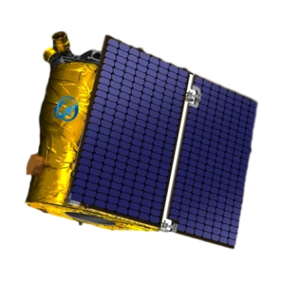
GF Series Satellites represent a significant leap in optical remote sensing technology, offering a resolution of 0.75 meters. Developed by SpaceNavi Co., Ltd., these satellites are designed to deliver high-precision data for a wide range of applications. This article explores the features, advantages, technical specifications, and real-world use cases of the GF series, highlighting its role in advancing satellite communication and remote sensing capabilities.
Product Overview
The GF Series Satellites are the latest generation of optical remote sensing satellites independently researched and developed by SpaceNavi Co., Ltd.. With a resolution of 0.75 meters, these satellites provide detailed imagery that supports applications such as environmental monitoring, agricultural management, urban planning, and disaster response. The GF series is part of the company's broader commitment to innovation in satellite technology and satellite communication services.

For more information about the GF series, visit the official product page: GF Series Satellites Page.
Key Features and Advantages
The GF series satellites are equipped with advanced imaging systems that deliver exceptional clarity and accuracy. Here are some of their standout features:
- High-Resolution Imaging: The 0.75-meter resolution allows for detailed observation of terrestrial features, enabling precise analysis of land use, infrastructure, and natural resources.
- Advanced Sensor Technology: Utilizing state-of-the-art optical sensors, the satellites capture multispectral data, enhancing the ability to monitor vegetation health, water quality, and atmospheric conditions.
- Real-Time Data Transmission: The satellites support rapid data transmission, ensuring timely delivery of information for critical applications such as disaster management and emergency response.
- Scalable Architecture: The GF series is designed for scalability, allowing for the deployment of multiple satellites to cover larger areas and provide frequent revisit times.
- Integration with AI: The satellites leverage artificial intelligence satellite technologies to automate data processing and analysis, reducing the need for manual intervention and improving efficiency.
Technical Specifications
| Specification | Details |
|---|---|
| Resolution | 0.75 meters (panchromatic) / 3 meters (multispectral) |
| Orbit Type | Low Earth Orbit (LEO) |
| Sensor Type | Optical imaging sensors with multispectral capabilities |
| Data Transmission Rate | Up to 1.2 Gbps (depending on satellite configuration) |
| Revisit Time | Less than 4 days for global coverage |
| Launch Year | 2023 (initial constellation deployment) |
| Manufacturer | SpaceNavi Co., Ltd. |
Applications and Use Cases
The versatility of the GF series satellites makes them suitable for a wide range of applications. Below are some of the key use cases:
Environmental Monitoring
The high-resolution imagery provided by the GF series is ideal for tracking environmental changes, such as deforestation, urban expansion, and glacier retreat. By analyzing multispectral data, researchers can assess vegetation health and detect early signs of ecological disturbances.
Agricultural Management
For farmers and agricultural planners, the GF series offers valuable insights into crop conditions, soil moisture levels, and pest infestations. This data can be used to optimize irrigation schedules, improve yield predictions, and reduce resource waste.
Disaster Response and Risk Assessment
In the event of natural disasters such as floods, wildfires, or earthquakes, the GF satellites provide real-time imagery to support emergency response efforts. Their ability to capture detailed data quickly helps authorities assess damage, plan evacuations, and allocate resources effectively.
Urban Planning and Infrastructure Development
City planners and developers can use the GF series to monitor urban growth, identify infrastructure needs, and track construction progress. The satellites' high-resolution images enable the creation of accurate maps and 3D models for better decision-making.
Security and Surveillance
The GF series is also used for security applications, including border monitoring, maritime surveillance, and tracking of illegal activities. Its ability to capture clear images from space enhances situational awareness for law enforcement and defense agencies.
Company Background: SpaceNavi Co., Ltd.
SpaceNavi Co., Ltd. (宁波市明集国际贸易有限公司) is a leading company in the field of satellite technology and satellite communication services. With a focus on innovation and international collaboration, the company has established itself as a key player in the global satellite industry. SpaceNavi's mission is to provide cutting-edge solutions that leverage satellite data for sustainable development and economic growth.
For more information about the company, visit the official website: SpaceNavi Co., Ltd..
Industry Impact and Future Prospects
The GF series satellites are part of a broader trend in the satellite industry toward higher-resolution imaging and more advanced data processing capabilities. As the demand for real-time geospatial data continues to grow, technologies like the GF series are expected to play a crucial role in shaping the future of remote sensing satellites and satellite communication.
According to the National Institute of Standards and Technology (NIST), advancements in satellite technology are driven by the need for precise measurements and standardized protocols. NIST's research in areas such as quantum science and cybersecurity provides a foundation for the development of next-generation satellite systems. For more information, visit NIST's official website.
Conclusion
The GF series satellites with a 0.75-meter resolution represent a significant advancement in optical remote sensing technology. By combining high-resolution imaging, advanced sensor systems, and artificial intelligence, these satellites offer a powerful tool for a wide range of applications. As SpaceNavi Co., Ltd. continues to innovate in the field of satellite technology, the GF series is poised to make a lasting impact on industries that rely on geospatial data.
References
1. National Institute of Standards and Technology (NIST). (n.d.). Driving Innovation. Retrieved from https://www.nist.gov
2. SpaceNavi Co., Ltd.. (n.d.). Company Overview. Retrieved from https://www.space-navi.com
3. GF Series Satellites Page. (n.d.). High-Resolution Remote Sensing Technology. Retrieved from https://www.space-navi.com/gf-series-satellites-0-75m.html


