Warning: Undefined array key "array_term_id" in /home/www/wwwroot/HTML/www.exportstart.com/wp-content/themes/1371/header-lBanner.php on line 78
Warning: Trying to access array offset on value of type null in /home/www/wwwroot/HTML/www.exportstart.com/wp-content/themes/1371/header-lBanner.php on line 78
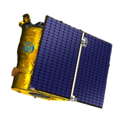
GF Series Satellites- SpaceNavi|High-Resolution Imaging&Advanced Sensors
SpaceNavi Co., Ltd., a leading innovator in satellite technology, has introduced the GF Series Satellites, a cutting-edge line of optical remote sensing satellites with a resolution of 0.75 meters. These satellites represent a significant advancement in Earth observation capabilities, offering unprecedented clarity and precision for a wide range of applications. This article delves into the features, technical specifications, and real-world impact of the GF Series, while also highlighting the company's commitment to technological excellence.
Product Overview
The GF Series Satellites are the result of independent research and development by SpaceNavi Co., Ltd., a company based in Ningbo, China. Designed to meet the growing demand for high-resolution Earth observation data, these satellites are equipped with advanced optical sensors that capture detailed imagery with a resolution of 0.75 meters. This level of detail enables users to discern objects as small as a car or a tree, making the GF Series a powerful tool for applications ranging from environmental monitoring to urban planning.


Key Features and Advantages
The GF Series Satellites boast several notable features that set them apart from traditional remote sensing systems:
- High-Resolution Imaging: The 0.75m resolution allows for the identification of small objects and fine details, enhancing the accuracy of data analysis.
- Advanced Optical Sensors: Utilizing state-of-the-art optical technology, these satellites ensure high-quality imagery even in challenging weather conditions.
- Wide Spectral Coverage: The satellites capture data across multiple spectral bands, enabling comprehensive environmental and agricultural assessments.
- Real-Time Data Transmission: Equipped with efficient communication systems, the GF Series ensures timely delivery of data to end-users.
- Scalable Applications: The satellites are designed to support a variety of industries, including agriculture, disaster management, and urban development.
Technical Specifications
| Parameter | Specification |
|---|---|
| Resolution | 0.75 meters (panchromatic) |
| Spectral Bands | Visible, Near-Infrared (NIR), and Shortwave Infrared (SWIR) |
| Swath Width | 15 kilometers |
| Revisit Time | 1-3 days (depending on orbit) |
| Data Transmission Rate | Up to 1 Gbps |
| Orbit Type | Low Earth Orbit (LEO) |
| Launch Year | 2023 |
Applications and Use Cases
The versatility of the GF Series Satellites makes them suitable for a wide range of applications:
- Agriculture: Farmers and agronomists can use the satellites to monitor crop health, optimize irrigation, and assess yield potential. The high-resolution imagery allows for precise identification of pests, nutrient deficiencies, and soil conditions.
- Environmental Monitoring: The satellites provide critical data for tracking deforestation, monitoring water quality, and assessing the impact of climate change. Their ability to capture detailed imagery helps scientists and policymakers make informed decisions.
- Disaster Management: In the event of natural disasters such as floods or wildfires, the GF Series can quickly provide up-to-date imagery to aid in emergency response and recovery efforts.
- Urban Planning: City planners and developers can utilize the satellites to monitor urban growth, manage infrastructure projects, and assess land use patterns. The high-resolution data enables the creation of accurate maps and 3D models.
- Security and Defense: The satellites' advanced imaging capabilities are also valuable for national security and defense applications, including border surveillance and monitoring of sensitive areas.
Company Background: SpaceNavi Co., Ltd.
SpaceNavi Co., Ltd. is a forward-thinking company based in Ningbo, China, dedicated to advancing satellite technology and remote sensing solutions. With a focus on innovation and customer-centric approaches, the company has established itself as a leader in the field of Earth observation systems. The development of the GF Series Satellites underscores SpaceNavi's commitment to delivering cutting-edge technology that meets the evolving needs of industries worldwide.
For more information about SpaceNavi Co., Ltd., visit their official website: SpaceNavi Co., Ltd.
Integration with Artificial Intelligence and Satellite Communication
The GF Series Satellites are not only advanced in their optical capabilities but also integrate seamlessly with emerging technologies such as artificial intelligence (AI) and satellite communication services. By leveraging AI algorithms, the satellites can automatically analyze and interpret data, providing actionable insights for users. This integration enhances the efficiency of data processing and reduces the time required for analysis.
Furthermore, the satellites are compatible with satellite communication services, ensuring that data can be transmitted securely and efficiently to ground stations. This capability is particularly valuable for applications that require real-time data, such as weather forecasting and disaster response. For more information on satellite communication services, visit SpaceNavi Co., Ltd..
Industry Impact and Future Prospects
The introduction of the GF Series Satellites has the potential to transform the remote sensing industry. With their high-resolution imaging and advanced capabilities, these satellites are poised to meet the growing demand for accurate and timely Earth observation data. As industries continue to rely on data-driven decision-making, the GF Series is expected to play a pivotal role in shaping the future of remote sensing technology.
According to the National Institute of Standards and Technology (NIST), the development of high-resolution imaging systems is critical for advancing technologies in fields such as cybersecurity, manufacturing, and next-generation communications. The GF Series aligns with these goals by providing a reliable and efficient solution for Earth observation. For more information on NIST's role in technological innovation, visit NIST's official website.
Conclusion
The GF Series Satellites from SpaceNavi Co., Ltd. represent a significant leap forward in optical remote sensing technology. With a resolution of 0.75 meters, these satellites offer unparalleled clarity and precision, making them a valuable asset for a wide range of applications. As the demand for high-quality Earth observation data continues to grow, the GF Series is well-positioned to meet the needs of industries worldwide. By integrating advanced technologies such as AI and satellite communication, SpaceNavi Co., Ltd. is setting new standards in the field of remote sensing.
References
NIST (National Institute of Standards and Technology): https://www.nist.gov
SpaceNavi Co., Ltd.: https://www.space-navi.com
GF Series Satellites Product Page: https://www.space-navi.com/gf-series-satellites-0-75m.html


