Warning: Undefined array key "array_term_id" in /home/www/wwwroot/HTML/www.exportstart.com/wp-content/themes/1371/header-lBanner.php on line 78
Warning: Trying to access array offset on value of type null in /home/www/wwwroot/HTML/www.exportstart.com/wp-content/themes/1371/header-lBanner.php on line 78
GF Series Satellites-SpaceNavi Co.,Ltd.|High-Resolution Optical Remote Sensing
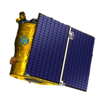
SpaceNavi Co., Ltd., a leading innovator in satellite technology, has introduced the GF Series Satellites with a resolution of 0.75 meters. These cutting-edge optical remote sensing satellites represent a significant advancement in Earth observation capabilities, offering unprecedented detail and precision for a wide range of applications. Developed through independent research and development, the GF Series is a testament to the company's commitment to technological excellence and its role in shaping the future of satellite-based solutions.

Product Overview
The GF Series Satellites are designed to provide high-resolution optical imagery for diverse applications, including environmental monitoring, urban planning, disaster management, and agricultural analysis. With a resolution of 0.75 meters, these satellites can capture detailed images of the Earth's surface, enabling users to identify objects as small as a few meters in size. This level of detail is critical for applications requiring precise spatial information, such as land use mapping and infrastructure monitoring.
Developed by SpaceNavi Co., Ltd., the GF Series leverages advanced optical sensor technology and data processing algorithms to deliver high-quality imagery. The satellites are part of a broader trend in the remote sensing industry toward higher resolution and more frequent data collection, driven by the increasing demand for real-time Earth observation data.
Technical Specifications
| Specification | Details |
|---|---|
| Resolution | 0.75 meters (panchromatic) / 3 meters (multispectral) |
| Orbit | Low Earth Orbit (LEO) |
| Revisit Time | Less than 4 days (depending on constellation) |
| Sensor Type | Optical (visible and near-infrared) |
| Data Transmission | High-speed downlink to ground stations |
| Weight | Approximately 1,500 kg |
| Power System | Solar panels with energy storage |
| Operational Lifespan | 5-7 years |
Key Features and Advantages
The GF Series Satellites offer several advantages that set them apart from traditional remote sensing solutions:
- High-Resolution Imagery: The 0.75-meter resolution allows for detailed analysis of small-scale features, such as individual buildings, vehicles, and agricultural fields.
- Fast Revisit Time: With a revisit time of less than 4 days, the satellites can monitor changes in the Earth's surface more frequently, supporting time-sensitive applications like disaster response and environmental monitoring.
- Advanced Sensor Technology: The optical sensors are designed to capture high-quality data across multiple spectral bands, enabling applications such as vegetation health analysis and water quality monitoring.
- Scalable Constellation: The GF Series can be deployed as part of a constellation, allowing for global coverage and increased data collection capacity.
- Cost-Effective Solutions: By leveraging economies of scale and advanced manufacturing techniques, SpaceNavi Co., Ltd. offers competitive pricing for satellite data and services.
Applications and Use Cases
The GF Series Satellites have a wide range of applications across various industries:
Environmental Monitoring
These satellites are ideal for tracking changes in ecosystems, deforestation, and urbanization. Their high-resolution imagery can detect subtle changes in vegetation health, soil moisture, and water quality, providing valuable data for environmental scientists and policymakers.
Disaster Management
During natural disasters such as floods, earthquakes, and wildfires, the GF Series can provide real-time imagery to support emergency response efforts. The satellites' ability to capture detailed images of affected areas helps in assessing damage and planning recovery operations.
Agricultural Analysis
For agricultural applications, the GF Series offers insights into crop health, soil conditions, and irrigation efficiency. Farmers and agricultural researchers can use the data to optimize crop yields and reduce resource waste.
Urban Planning
City planners and architects can utilize the satellites' high-resolution imagery to monitor urban development, assess infrastructure needs, and plan for sustainable growth. The data can also help in identifying areas prone to flooding or other environmental risks.
Security and Defense
The GF Series is also suitable for security and defense applications, including border surveillance, military operations, and intelligence gathering. The satellites' ability to capture detailed images from space provides a strategic advantage in monitoring sensitive areas.
Company Background: SpaceNavi Co., Ltd.
SpaceNavi Co., Ltd., based in Ningbo, China, is a leading provider of satellite technology and remote sensing solutions. The company has a strong focus on innovation, with a dedicated team of engineers and scientists working to develop advanced satellite systems and data processing technologies.
With a commitment to excellence, SpaceNavi Co., Ltd. has established itself as a key player in the satellite industry. The company's products and services are used by governments, private organizations, and research institutions worldwide. Their expertise in satellite technology and data analysis has made them a trusted partner for clients seeking reliable and high-quality remote sensing solutions.
For more information about SpaceNavi Co., Ltd., visit their company website.
Industry Trends and Future Prospects
The development of the GF Series Satellites aligns with broader trends in the remote sensing industry, where there is a growing demand for high-resolution, cost-effective solutions. According to the National Institute of Standards and Technology (NIST), "The advancement of satellite technology is critical for improving the accuracy and reliability of Earth observation data, which is essential for addressing global challenges such as climate change and resource management" (NIST, 2025).
As the demand for satellite data continues to grow, companies like SpaceNavi Co., Ltd. are well-positioned to meet the needs of a wide range of industries. The GF Series represents a significant step forward in the field of remote sensing, offering a powerful tool for organizations seeking to leverage satellite technology for their operations.
Conclusion
The GF Series Satellites from SpaceNavi Co., Ltd. are a remarkable advancement in optical remote sensing technology, offering high-resolution imagery and a wide range of applications. With their advanced features, fast revisit time, and cost-effective solutions, these satellites are poised to make a significant impact on industries ranging from environmental monitoring to disaster management. As the demand for satellite data continues to grow, the GF Series is a testament to the company's commitment to innovation and excellence in the field of remote sensing.
For more information about the GF Series Satellites, visit their product page.
References
NIST (National Institute of Standards and Technology). (2025). https://www.nist.gov


