Warning: Undefined array key "array_term_id" in /home/www/wwwroot/HTML/www.exportstart.com/wp-content/themes/1371/header-lBanner.php on line 78
Warning: Trying to access array offset on value of type null in /home/www/wwwroot/HTML/www.exportstart.com/wp-content/themes/1371/header-lBanner.php on line 78
GF Series Satellites 0.75m Resolution - SpaceNavi Co., Ltd.
Introduction to the GF Series Satellites
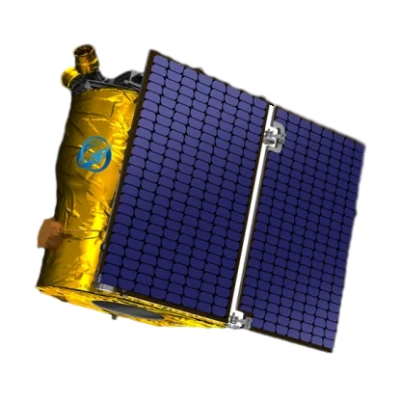
The GF Series satellites represent a significant advancement in optical remote sensing technology, developed by SpaceNavi Co., Ltd., a leading company in the aerospace and satellite industry. These satellites are designed to deliver high-resolution imagery with a remarkable 0.75-meter resolution, enabling detailed analysis of Earth's surface for a wide range of applications. The GF Series is part of the company's commitment to innovation, combining cutting-edge technology with practical utility to meet the evolving needs of global markets.

Key Features and Capabilities
The GF Series satellites are engineered to provide exceptional performance in various operational scenarios. Their high-resolution imaging capability allows for the detection of small objects and subtle changes on the Earth's surface, making them ideal for applications such as urban planning, environmental monitoring, and disaster management. The satellites are equipped with advanced optical sensors that capture detailed images in multiple spectral bands, enhancing their ability to analyze different materials and conditions.
Advanced Optical Sensors
Equipped with state-of-the-art optical sensors, the GF Series satellites can capture images with a resolution of 0.75 meters. This level of detail is critical for applications requiring precise measurements and analysis, such as agricultural monitoring and infrastructure inspection. The sensors are designed to operate in a wide range of atmospheric conditions, ensuring consistent performance and reliability.
Real-Time Data Transmission
One of the standout features of the GF Series is its ability to transmit data in real-time. This capability is essential for time-sensitive applications, such as weather forecasting and emergency response. The satellites use a robust communication system to ensure that data is delivered quickly and accurately, enabling users to make informed decisions based on the latest information.
Technical Specifications
| Specification | Details |
|---|---|
| Resolution | 0.75 meters (panchromatic) / 3 meters (multispectral) |
| Orbit Type | Low Earth Orbit (LEO) |
| Revisit Time | As low as 4 days (depending on constellation) |
| Spectral Bands | Visible, Near-Infrared, Shortwave Infrared |
| Data Transmission Rate | Up to 1 Gbps |
| Launch Date | 2023 (GF-03D) |
Applications and Use Cases
The versatility of the GF Series satellites makes them suitable for a wide range of applications. From environmental monitoring to urban planning, these satellites provide valuable insights that support decision-making processes across various industries.
Environmental Monitoring
The high-resolution imagery provided by the GF Series is invaluable for environmental monitoring. Scientists and researchers can use the data to track changes in ecosystems, monitor deforestation, and assess the impact of climate change. The satellites' ability to capture images in multiple spectral bands allows for the analysis of vegetation health, water quality, and soil conditions.
Disaster Management
In the event of natural disasters, such as earthquakes or floods, the GF Series satellites can provide critical information for emergency response efforts. The real-time data transmission capability enables rapid assessment of affected areas, helping authorities to allocate resources effectively and coordinate rescue operations.
Urban Planning and Infrastructure Development
Urban planners and city developers can leverage the GF Series satellites to monitor urban growth, assess infrastructure projects, and plan for future development. The detailed imagery allows for the identification of potential issues, such as traffic congestion or land use conflicts, enabling more informed decision-making.
Company Background: SpaceNavi Co., Ltd.
SpaceNavi Co., Ltd. is a prominent player in the aerospace and satellite industry, known for its innovative solutions and commitment to excellence. Based in Ningbo, China, the company has established itself as a leader in the development and deployment of remote sensing satellites. With a focus on research and development, SpaceNavi continuously strives to enhance its product offerings to meet the demands of a rapidly evolving market.
The company's dedication to innovation is evident in the development of the GF Series satellites, which reflect its expertise in optical remote sensing technology. By combining advanced engineering with a deep understanding of market needs, SpaceNavi has positioned itself as a trusted partner for organizations seeking reliable and high-performance satellite solutions.
Industry Impact and Future Prospects
The introduction of the GF Series satellites has significant implications for the remote sensing industry. As the demand for high-resolution imagery continues to grow, SpaceNavi's offerings are well-positioned to meet this need. The company's focus on technological advancement and customer satisfaction ensures that its products remain at the forefront of the market.
Looking ahead, SpaceNavi is committed to further enhancing the capabilities of its satellites through ongoing research and development. The company is exploring new applications for its technology, including the integration of artificial intelligence to improve data analysis and interpretation. This forward-thinking approach will enable SpaceNavi to stay competitive and continue to deliver innovative solutions to its customers.
Conclusion
The GF Series satellites from SpaceNavi Co., Ltd. represent a significant leap forward in optical remote sensing technology. With their high-resolution imaging capabilities, real-time data transmission, and versatile applications, these satellites are poised to make a lasting impact on various industries. As the demand for detailed and accurate data continues to grow, the GF Series is well-equipped to meet the challenges of the future.
References
For more information on the standards and research that underpin satellite technology, visit the National Institute of Standards and Technology (NIST). NIST plays a critical role in advancing technology through its research and development efforts, ensuring that innovations meet the highest standards of quality and reliability.
According to NIST, "The development of precise measurement standards is essential for the advancement of technology and the improvement of quality of life for all Americans." This principle aligns with SpaceNavi's commitment to excellence and innovation in the satellite industry.


