- الأفريقي
- الألبانية
- الأمهرية
- عربي
- الأرمنية
- أذربيجاني
- الباسكية
- البيلاروسية
- البنغالية
- البوسنية
- البلغارية
- الكاتالونية
- سيبوانو
- الصين
- كورسيكي
- الكرواتية
- التشيكية
- دانماركي
- هولندي
- إنجليزي
- الإسبرانتو
- الإستونية
- الفنلندية
- فرنسي
- الفريزية
- الجاليكية
- جورجي
- الألمانية
- اليونانية
- الغوجاراتية
- الكريولية الهايتية
- الهاوسا
- هاواي
- العبرية
- لا
- مياو
- المجرية
- الأيسلندية
- إيجبو
- اللغة الإندونيسية
- ايرلندي
- ايطالي
- اليابانية
- الجاوية
- كانادا
- الكازاخستانية
- الخميرية
- رواندية
- كوري
- كردي
- قيرغيزستان
- تَعَب
- اللاتينية
- اللاتفية
- الليتوانية
- اللوكسمبورغية
- المقدونية
- اللغة الملغاشية
- الملايو
- المالايالامية
- المالطية
- الماوري
- الماراثى
- المنغولية
- ميانمار
- النيبالية
- النرويجية
- النرويجية
- أوكيتاني
- البشتونية
- الفارسية
- بولندي
- البرتغالية
- البنجابية
- روماني
- الروسية
- ساموا
- الغيلية الاسكتلندية
- الصربية
- إنجليزي
- شونا
- السندية
- السنهالية
- السلوفاكية
- السلوفينية
- الصومالية
- الأسبانية
- اللغة السوندانية
- السواحلية
- السويدية
- التاغالوغية
- الطاجيكية
- التاميلية
- التتار
- التيلجو
- تايلاندي
- اللغة التركية
- تركمان
- الأوكرانية
- الأردية
- الأويغور
- الأوزبكية
- الفيتنامية
- الويلزية
- يساعد
- اليديشية
- اليوروبا
- الزولو
The Expanding Horizon of Satellite Data: Empowering Global Solutions for Tomorrow's Challenges
As the world grapples with complex environmental, societal, and technological challenges, satellite data continues to provide the vital insights needed for informed decision-making. With Landsat, QuickBird, and infrared satellite data leading the charge, the next frontier in satellite technology is set to empower solutions for everything from global security to advanced infrastructure development. This article explores the cutting-edge applications of satellite data, the role of collaboration in advancing satellite research, and the exciting future of satellite technologies.
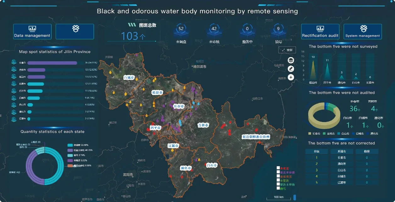
1. Satellite Data for Global Security and Disaster Response
The role of satellite data types in security and disaster response has become increasingly pivotal in today’s volatile world. Whether it's tracking military movements, monitoring border security, or detecting potential threats, satellite data has become an indispensable tool for global security agencies.
Landsat imagery, for example, can track infrastructure changes, monitor political developments, and provide critical intelligence for managing national security. By analyzing land use and urban development over time, security agencies can identify areas of concern, such as illegal construction or sudden changes in infrastructure that might indicate destabilization.
Similarly, infrared satellite imagery provides crucial information for monitoring environmental disasters such as wildfires, floods, and oil spills. Infrared satellite sensors detect heat signatures and changes in temperature, making it easier to detect ongoing crises. For example, satellites equipped with thermal infrared sensors can detect the onset of a wildfire and help emergency response teams deploy resources faster and more efficiently. In the case of floods, Landsat can assess the extent of floodwaters and help predict areas that might be at risk.
The ability to deploy satellites in conflict zones or disaster areas provides real-time data, allowing for quicker response and more effective management of crises. This data can even help track the recovery process after a disaster, enabling governments and organizations to monitor rebuilding efforts and ensure that aid is reaching the right locations.
2. Harnessing Satellite Data for Sustainable Agriculture and Food Security
As the global population continues to grow, ensuring food security has become one of the most pressing issues of our time. Satellite data is playing a transformative role in shaping agricultural practices and ensuring sustainable food production. Technologies like Landsat and QuickBird provide high-resolution imagery that enables farmers to monitor crop health, optimize irrigation, and reduce the environmental footprint of agriculture.
Infrared satellite data, for instance, is especially useful in assessing plant health and predicting crop yields. By analyzing the amount of infrared light reflected by crops, farmers can determine whether their plants are healthy or stressed due to water scarcity, pests, or diseases. This real-time data allows farmers to take corrective actions, such as adjusting irrigation schedules, using targeted pesticide applications, or even changing planting strategies to increase yields and minimize resource waste.
In addition, Landsat data provides long-term insights into land-use changes, helping policymakers track deforestation, agricultural expansion, and other trends that impact food production. By studying these patterns, governments and agricultural organizations can implement strategies to improve food security, reduce environmental degradation, and enhance crop resilience in the face of climate change.
3. Satellite Data and the Circular Economy: Reducing Waste and Promoting Sustainability
The concept of the circular economy, which emphasizes reducing waste and maximizing the reuse of materials, is gaining traction across industries. Satellite data can play a significant role in supporting this model by tracking resource flows, managing waste, and ensuring that materials are recycled and reused rather than discarded.
For instance, Landsat imagery can be used to monitor landfills and track waste disposal trends. By analyzing changes in land cover and the expansion of landfill sites, local authorities can identify areas where waste management systems are inadequate, and implement more sustainable practices. Additionally, satellites are used to monitor the progress of recycling programs and determine how much material is being diverted from landfills.
Satellite data also helps track industrial resource usage, providing insights into energy consumption, water use, and raw material extraction. This information is essential for industries looking to reduce their environmental impact and transition to more sustainable practices. As part of the circular economy, satellite data can be used to map the lifecycle of products from raw material extraction to disposal, enabling companies to optimize supply chains and reduce waste.
4. Enabling Innovation in Infrastructure and Smart Cities
The construction of smart cities is a major goal for urban planners worldwide. These cities rely on advanced technologies to optimize resource usage, improve transportation systems, and enhance the quality of life for residents. Satellite data is central to the planning and development of smart cities, providing the real-time monitoring and data analysis required to design efficient, sustainable urban environments.
For instance, infrared satellite data helps cities assess heat islands—areas that are significantly warmer than surrounding rural areas due to human activities and dense infrastructure. By identifying these heat islands, city planners can implement measures such as increasing green spaces, improving urban tree canopies, and implementing cooling techniques to reduce urban temperatures.
In terms of infrastructure, satellite data types can help monitor road networks, detect changes in infrastructure, and optimize traffic patterns. Landsat data can be used to track urban sprawl, helping planners identify areas in need of new infrastructure and ensuring that growth is sustainable. Additionally, QuickBird satellite imagery offers high-resolution images of cities, which can be used for urban mapping, monitoring construction projects, and designing efficient transportation systems.
5. Satellite Data for Climate Change Mitigation and Adaptation
Climate change is perhaps the most urgent global challenge, and satellite technology plays a critical role in monitoring the Earth's changing climate. From tracking greenhouse gas emissions to studying sea level rise and deforestation, satellite data provides invaluable insights into the state of the environment.
Landsat and infrared satellite imagery are key tools for monitoring forest cover, detecting changes in biodiversity, and assessing the effects of climate change on ecosystems. These satellites allow researchers to monitor carbon sequestration efforts in forests, assess the health of marine environments, and track the melting of glaciers and ice caps. This data provides essential information for climate change mitigation and adaptation strategies.
Additionally, satellite data is being used to monitor the effectiveness of climate policies, such as carbon offset programs and emissions reductions targets. By providing independent and reliable data, satellites allow governments to verify progress and adjust strategies to meet their climate goals.
6. The Role of Artificial Intelligence in Satellite Data Processing
As the amount of data produced by satellites increases exponentially, the need for advanced data processing tools has become more pressing. Artificial intelligence (AI) and machine learning (ML) are being integrated into satellite data analysis to help process and interpret large volumes of information efficiently.
AI-powered systems can automatically detect and classify objects in satellite images, such as vehicles, buildings, or vegetation, making it easier to monitor changes over time. For example, AI algorithms can identify new construction in urban areas or track deforestation in remote forests. These technologies also help with predictive modeling, allowing for forecasts of environmental events such as floods, wildfires, and droughts.
Machine learning algorithms can also analyze satellite imagery to detect anomalies and patterns that may not be visible to the human eye. For instance, satellite data can be used to predict crop yields based on environmental conditions and historical data, providing farmers with valuable insights for improving productivity and food security.
Conclusion: The Unlimited Potential of Satellite Data for a Sustainable Future
The potential of satellite data to address global challenges is boundless. From improving disaster management and enhancing food security to advancing urban development and combating climate change, satellite data types like Landsat, QuickBird, and infrared satellite imagery are helping to shape the future of the planet.
With the continuous improvement of satellite technology, the integration of AI, and the growing trend of global collaboration, we are entering an era where satellite data will play an even greater role in solving the world’s most pressing problems. By harnessing this technology, we can create a more sustainable, resilient, and equitable future for all.


