Warning: Undefined array key "array_term_id" in /home/www/wwwroot/HTML/www.exportstart.com/wp-content/themes/1371/header-lBanner.php on line 78
Warning: Trying to access array offset on value of type null in /home/www/wwwroot/HTML/www.exportstart.com/wp-content/themes/1371/header-lBanner.php on line 78
GF Series Satellites 0.75m Resolution - SpaceNavi Co., Ltd. | High-Resolution Imaging, Real-Time Data Processing
Introduction
SpaceNavi Co., Ltd., a leading innovator in satellite technology, has introduced the GF Series Satellites with a groundbreaking resolution of 0.75 meters. These satellites represent a significant advancement in optical remote sensing, offering unparalleled clarity and precision for a wide range of applications. This article delves into the features, advantages, technical specifications, and real-world applications of the GF Series, while also exploring the company's background and commitment to innovation.
Product Overview
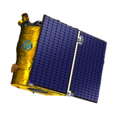
The GF Series Satellites are the latest in a line of optical remote sensing satellites developed independently by SpaceNavi Co., Ltd. These satellites are designed to capture high-resolution images of the Earth's surface, enabling detailed analysis for various industries. The 0.75m resolution allows for the identification of small objects and features, making these satellites ideal for applications such as urban planning, environmental monitoring, and disaster management.

Key Features and Advantages
High-Resolution Imaging
The GF Series Satellites boast a resolution of 0.75 meters, which is among the highest in the industry. This level of detail allows users to distinguish between small objects, such as vehicles, buildings, and even individual trees. The high-resolution images are invaluable for applications requiring precise data, such as agricultural monitoring and infrastructure development.
Advanced Optical Sensors
Equipped with state-of-the-art optical sensors, these satellites can capture images in multiple spectral bands. This capability enables the analysis of different aspects of the Earth's surface, including vegetation health, water quality, and urban heat islands. The multi-spectral data provides a comprehensive view of the environment, supporting informed decision-making.
Real-Time Data Processing
SpaceNavi Co., Ltd. has integrated real-time data processing capabilities into the GF Series. This feature allows for immediate analysis of captured images, reducing the time required to derive actionable insights. Real-time processing is crucial for applications such as disaster response, where timely information can save lives and resources.
Global Coverage
With a global coverage capability, the GF Series Satellites can monitor any location on Earth. This makes them ideal for international projects, such as climate change research and global environmental monitoring. The satellites' ability to provide consistent data across different regions ensures a comprehensive understanding of global phenomena.
Technical Specifications
| Specification | Details |
|---|---|
| Resolution | 0.75 meters |
| Spectral Bands | Visible, Near-Infrared, Shortwave Infrared |
| Orbit Type | Low Earth Orbit (LEO) |
| Revisit Time | As fast as 3 days |
| Data Transmission Rate | Up to 10 Gbps |
| Power System | Solar Panels with Battery Storage |
| Launch Date | 2023 |
Applications and Use Cases
Environmental Monitoring
The GF Series Satellites are extensively used for environmental monitoring. Their high-resolution imaging capabilities enable the tracking of deforestation, urban expansion, and changes in land use. This data is crucial for governments and environmental organizations to develop sustainable policies and manage natural resources effectively.
Disaster Management
In disaster management, the GF Series provides critical information for assessing damage and planning recovery efforts. The satellites can quickly capture images of affected areas, allowing emergency responders to identify the most urgent needs and allocate resources efficiently. This capability is particularly valuable in the aftermath of natural disasters such as earthquakes, floods, and wildfires.
Urban Planning
Urban planners utilize the GF Series to monitor city growth and infrastructure development. The detailed images help in identifying areas that require improvement, such as transportation networks and public services. This data supports the creation of efficient and sustainable urban environments.
AgriTech
For the agriculture sector, the GF Series offers insights into crop health and yield predictions. The multi-spectral data allows farmers to monitor soil conditions, detect pests, and optimize irrigation. This technology enhances productivity and reduces the environmental impact of farming practices.
Company Background: SpaceNavi Co., Ltd.
SpaceNavi Co., Ltd., based in Ningbo, China, is a leading company in the satellite technology industry. The company has a strong focus on research and development, continuously innovating to meet the evolving needs of its clients. With a team of experienced engineers and scientists, SpaceNavi is committed to advancing the field of remote sensing and satellite communications.
As a pioneer in the development of optical remote sensing satellites, SpaceNavi has established itself as a trusted name in the industry. The company's dedication to quality and innovation is reflected in its products, which are designed to deliver exceptional performance and reliability. SpaceNavi's mission is to provide cutting-edge solutions that address global challenges and support sustainable development.
For more information about SpaceNavi Co., Ltd., visit their official website.
Industry Impact and Future Prospects
The introduction of the GF Series Satellites has had a significant impact on the remote sensing industry. By offering high-resolution data and advanced features, SpaceNavi Co., Ltd. has set a new standard for satellite technology. The company's commitment to innovation ensures that it remains at the forefront of the industry, continuously developing new solutions to meet the needs of its clients.
Looking ahead, SpaceNavi Co., Ltd. plans to expand its satellite fleet, enhancing its capabilities to provide even more comprehensive data. The company is also exploring partnerships with other organizations to develop new applications for its technology. These efforts will further solidify SpaceNavi's position as a leader in the satellite industry.
Conclusion
The GF Series Satellites with a 0.75m resolution represent a significant advancement in optical remote sensing technology. With their high-resolution imaging, advanced sensors, and real-time data processing capabilities, these satellites offer a wide range of applications across various industries. SpaceNavi Co., Ltd. continues to innovate and lead in the satellite technology sector, providing solutions that address global challenges and support sustainable development.
References
Authoritative Source: National Institute of Standards and Technology (NIST). While no specific search results were found for the term "GF Series Satellites," NIST's role in advancing measurement science and technology underscores the importance of precision and innovation in the satellite industry. For further information on standards and research in technology, visit the NIST website.


