- アフリカ
- アルバニア語
- アムハラ語
- アラビア語
- アルメニア語
- アゼルバイジャン語
- バスク語
- ベラルーシ語
- ベンガル語
- ボスニア語
- ブルガリア語
- カタロニア語
- セブアノ語
- 中国
- コルシカ
- クロアチア語
- チェコ語
- デンマーク語
- オランダ語
- 英語
- エスペラント
- エストニア語
- フィンランド語
- フランス語
- フリジア語
- ガリシア語
- グルジア語
- ドイツ語
- ギリシャ語
- グジャラート語
- ハイチ語
- ハウサ語
- ハワイアン
- ヘブライ語
- いいえ
- ミャオ族
- ハンガリー語
- アイスランド語
- イボ語
- インドネシア語
- アイルランド人
- イタリア語
- 日本語
- ジャワ語
- カンナダ語
- カザフ語
- クメール語
- ルワンダ
- 韓国語
- クルド
- キルギス語
- 労働
- ラテン
- ラトビア語
- リトアニア語
- ルクセンブルク語
- マケドニア語
- マダガスカル語
- マレー語
- マラヤーラム語
- マルタ語
- マオリ語
- マラーティー語
- モンゴル語
- ミャンマー
- ネパール語
- ノルウェー語
- ノルウェー語
- オック語
- パシュトゥー語
- ペルシャ語
- 研磨
- ポルトガル語
- パンジャブ語
- ルーマニア語
- ロシア
- サモア語
- スコットランド・ゲール語
- セルビア語
- 英語
- ショナ語
- シンディー語
- シンハラ語
- スロバキア語
- スロベニア語
- ソマリア
- スペイン語
- スンダ語
- スワヒリ語
- スウェーデン語
- タガログ語
- タジク語
- タミル語
- タタール語
- テルグ語
- タイ語
- トルコ語
- トルクメン語
- ウクライナ語
- ウルドゥー語
- ウイグル
- ウズベク語
- ベトナム語
- ウェールズ語
- ヘルプ
- イディッシュ語
- ヨルバ語
- ズールー語
Unlocking New Frontiers With Satellite Remote Sensing Data
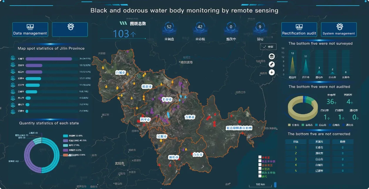
In today’s data-driven world, satellite remote sensing data is revolutionizing how we observe, analyze, and respond to changes on Earth. From environmental monitoring and disaster management to urban planning and agricultural development, this technology provides invaluable insights across industries. With the advent of high resolution remote sensing images and advanced remote sensing satellite image technology, both public and private sectors now have access to unprecedented levels of detail and accuracy. As demand grows, so does the importance of reliable, timely, and high-quality remotely sensed satellite imagery.
Expanding Visibility Through High Resolution Remote Sensing Images
High resolution remote sensing images offer detailed views of the Earth’s surface, enabling precise detection of changes, objects, or patterns. Whether it's monitoring coastal erosion, tracking deforestation, or mapping urban development, these images allow for enhanced spatial analysis and timely decision-making. Organizations increasingly rely on remote sensing and satellite imagery to optimize planning and resource management. Thanks to improvements in satellite optics and sensors, the clarity and frequency of remote sensing satellite image capture continue to improve, expanding their applicability across fields.
Illuminating the Night With Night Time Light Satellite Imagery
One of the more specialized applications of satellite-based observation is night time light satellite imagery. This unique form of imaging captures light emissions on the Earth’s surface at night—useful for monitoring electricity consumption, identifying population densities, and observing economic activity patterns. For example, humanitarian organizations use night time light satellite imagery to assess disaster impacts, while economists may use it to analyze development levels in remote regions. By integrating these insights with other satellite remote sensing data, we achieve a fuller, multidimensional understanding of global phenomena.
The Role of Panchromatic Satellite Imagery in Enhanced Resolution
Panchromatic satellite imagery plays a key role in providing crisp black-and-white imagery at higher spatial resolutions compared to multispectral sensors. By using panchromatic satellite imagery for pan-sharpening, analysts can merge it with lower-resolution color images to create sharper, more detailed visualizations. This technique significantly boosts the interpretability of remotely sensed satellite imagery, supporting tasks like infrastructure mapping, land cover classification, and environmental assessment. The increasing availability of high resolution remote sensing satellites list has also contributed to the greater use of panchromatic methods in various applications.
Conclusion: Transforming Earth Observation With Advanced Satellite Imagery
As satellite capabilities continue to evolve, the scope and utility of satellite remote sensing data will expand further. With a growing high resolution remote sensing satellites list and diversified imagery formats—such as night time light satellite imagery and panchromatic satellite imagery—stakeholders across sectors can make smarter, faster, and more sustainable decisions. The convergence of these technologies has ushered in a new era of remote sensing and satellite imagery, making once-invisible patterns visible and offering deeper insights into our dynamic planet. By leveraging remotely sensed satellite imagery, we not only improve our understanding of the Earth but also gain the tools needed to shape a more informed and responsive future.


