- អាហ្រ្វិក
- អាល់បានី
- អាំហារិក
- ភាសាអារ៉ាប់
- អាមេនី
- អាស៊ែបៃហ្សង់
- បាស
- បេឡារុស្ស
- បង់ក្លាដែស
- បូស្នៀ
- ប៊ុលហ្គារី
- កាតាឡាន
- សេប៊ូណូ
- ចិន
- Corsican
- ក្រូអាត
- ឆេក
- ដាណឺម៉ាក
- ហូឡង់
- ភាសាអង់គ្លេស
- អេស្ប៉ារ៉ាន់តូ
- អេស្តូនី
- ហ្វាំងឡង់
- បារាំង
- ហ្វ្រីសៀន
- ហ្គាលីសៀន
- ហ្សកហ្ស៊ី
- អាឡឺម៉ង់
- ក្រិក
- ហ្គូចារ៉ាទី
- ក្រេអូល ហៃទី
- ហូសា
- ហាវ៉ៃ
- ភាសាហេព្រើរ
- ទេ
- Miao
- ហុងគ្រី
- អ៊ីស្លង់
- អ៊ីកបូ
- ឥណ្ឌូនេស៊ី
- អៀរឡង់
- អ៊ីតាលី
- ជប៉ុន
- ជ្វា
- កាណាដា
- កាហ្សាក់ស្ថាន
- ខ្មែរ
- រវ៉ាន់ដា
- កូរ៉េ
- ឃឺដ
- កៀហ្ស៊ីស៊ី
- ពលកម្ម
- ឡាតាំង
- ឡាតវី
- លីទុយអានី
- លុចសំបួរ
- ម៉ាសេដូនៀ
- ម៉ាឡាហ្គាស៊ី
- ម៉ាឡេ
- ម៉ាឡាយ៉ាឡា
- ម៉ាល់តា
- ម៉ៅរី
- ម៉ារ៉ាធី
- ម៉ុងហ្គោលី
- មីយ៉ាន់ម៉ា
- នេប៉ាល់
- ន័រវេស
- ន័រវេស
- អូស៊ីតាន់
- ប៉ាសតូ
- ពែរ្ស
- ប៉ូឡូញ
- ព័រទុយហ្គាល់
- ពុនចាប៊ី
- រ៉ូម៉ានី
- រុស្សី
- សាម័រ
- ស្កុតឡេក
- ស៊ែប៊ី
- ភាសាអង់គ្លេស
- សូណា
- ស៊ីនឌី
- ស៊ីនហាឡា
- ស្លូវ៉ាគី
- ស្លូវេនី
- សូម៉ាលី
- ភាសាអេស្ប៉ាញ
- ស៊ុនដា
- ស្វាហ៊ីលី
- ស៊ុយអែត
- តាកាឡុក
- តាជីក
- តាមីល
- តាតា
- តេលូហ្គូ
- ថៃ
- ទួរគី
- តួកមេន
- អ៊ុយក្រែន
- អ៊ូឌូ
- អ៊ុយហ្គួរ
- អ៊ូសបេក
- វៀតណាម
- វែល
- ជំនួយ
- យីឌីស
- យូរូបា
- ហ្សូលូ
The Future of Satellite Data: Paving the Way for Global Innovation and Sustainable Solutions
As satellite technology continues to advance, it offers new possibilities for solving some of the most pressing challenges of our time. From providing critical insights for climate change mitigation to optimizing the use of natural resources, satellite data types such as Landsat, QuickBird, and infrared satellite imagery are central to developing innovative solutions across multiple sectors. This article explores the future of satellite technology and its potential to drive global innovation, foster sustainable development, and improve lives across the world.
1. The Role of Satellite Data in Biodiversity Conservation
Biodiversity is facing an unprecedented decline due to factors like deforestation, habitat loss, and climate change. Satellite data is playing a pivotal role in biodiversity conservation efforts, offering unprecedented insights into ecosystems and wildlife habitats. By leveraging Landsat and QuickBird satellite imagery, scientists and conservationists are able to monitor changes in habitats, track endangered species, and identify areas in need of protection.
Infrared satellite data, in particular, has proven valuable for monitoring forests and wetlands. It can detect subtle changes in vegetation health, providing early warning signs of stress or degradation. By tracking deforestation, researchers can assess the effectiveness of conservation policies and understand the dynamics of forest ecosystems. Furthermore, satellite data helps map protected areas, ensuring that wildlife corridors are preserved and connected to prevent the fragmentation of ecosystems.
As part of international conservation efforts, satellites are also used to monitor marine biodiversity. With Landsat and other satellites, researchers can track coral reef health, detect pollution, and study ocean temperatures—all of which are critical to preserving marine life. By providing continuous and detailed monitoring, satellite data supports biodiversity conservation in a more systematic and global way, helping to safeguard ecosystems for future generations.
2. Satellite Data and the Renewable Energy Revolution
As the world transitions to a cleaner, more sustainable energy future, satellite data types are proving to be invaluable in the renewable energy sector. With the global demand for energy growing, the ability to harness renewable sources such as solar, wind, and geothermal has never been more important. Satellites like Landsat, QuickBird, and Sentinel are being used to assess the viability of renewable energy projects and optimize energy production.
For instance, satellite data is essential for assessing solar energy potential. By mapping cloud cover, sunlight intensity, and geographical features, satellite imagery helps determine the most suitable locations for solar farms. Infrared satellite sensors can be used to measure land surface temperatures, which are important for understanding how much energy can be generated from solar panels in a given region. With more accurate data on solar irradiance and local conditions, energy companies can improve the efficiency of solar power installations and ensure their long-term sustainability.
In addition to solar energy, satellite data is also critical in the deployment of wind energy. By analyzing wind patterns and identifying optimal wind speeds using Landsat and other satellite systems, planners can determine the most effective locations for wind farms. With this data, countries can make more informed decisions on where to invest in renewable energy infrastructure and better manage their energy resources.
Furthermore, satellite data is being used to monitor the progress of geothermal energy projects by tracking changes in land temperature and geological activity. These innovations make renewable energy more efficient and scalable, helping the world reduce its dependence on fossil fuels.
3. Satellite Data in Transportation and Infrastructure Planning
The future of transportation is rapidly evolving, with innovations in autonomous vehicles, smart traffic management, and sustainable infrastructure becoming more mainstream. Satellite data types play a critical role in enabling smarter, safer, and more efficient transportation networks. From optimizing traffic flow to monitoring transportation infrastructure, satellites provide key data that helps build the cities of tomorrow.
For instance, Landsat and QuickBird satellites are used to track changes in road networks, detect traffic patterns, and monitor infrastructure health. In rapidly growing urban areas, satellite data helps planners assess transportation needs, prioritize road maintenance, and design better routes for public transportation. With high-resolution satellite imagery, transportation planners can create more efficient transit systems, reduce congestion, and improve accessibility for underserved areas.
The integration of satellite data in autonomous vehicle development is another exciting frontier. Autonomous vehicles rely on highly accurate and up-to-date mapping data for safe navigation. By incorporating satellite data, vehicles can receive real-time information about road conditions, construction zones, and traffic, enabling better decision-making in dynamic environments. As autonomous vehicles become more widespread, satellite data will be crucial for enhancing vehicle safety, reducing accidents, and improving transportation efficiency.
Moreover, satellite data is essential for monitoring the state of infrastructure such as bridges, roads, and railways. By using infrared satellite sensors to assess surface conditions and detect cracks or damage, engineers can conduct early inspections, perform maintenance proactively, and reduce the risk of infrastructure failure.
4. The Potential of Satellite Data in Water Resource Management
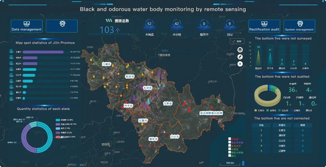
Water scarcity is one of the most pressing global challenges, with many regions already facing extreme droughts, poor water quality, and limited access to freshwater. In response, satellite data types are being increasingly utilized to monitor and manage water resources efficiently. Landsat, QuickBird, and infrared satellite imagery provide essential data for assessing water availability, quality, and distribution.
Satellite data enables real-time monitoring of water bodies, including rivers, lakes, and reservoirs. Infrared satellite data is especially valuable for detecting changes in water temperature, which can signal pollution or contamination. Landsat imagery helps track changes in land use, enabling authorities to identify areas where over-extraction of water may be occurring. This information is crucial for maintaining balanced water systems, especially in regions where freshwater resources are limited.
In addition, satellite data supports water management for agriculture. By monitoring soil moisture levels, vegetation health, and water availability, satellite data helps farmers optimize irrigation practices, reduce water waste, and increase crop productivity. This data is also valuable for managing water quality in agricultural runoff, preventing contamination of water supplies.
Moreover, satellite technology can be used to assess the impact of climate change on water resources, such as shifts in rainfall patterns, the retreat of glaciers, and the shrinking of freshwater reserves. This information helps policymakers and water managers prepare for future challenges and develop sustainable water management strategies.
5. Satellite Data and the Future of Space-Based Internet Connectivity
Additionally, satellite data will play a critical role in managing and optimizing satellite networks for internet connectivity. By monitoring signal strength, latency, and network congestion from space, operators can ensure that the satellite constellation delivers consistent service. Real-time satellite monitoring will enable rapid troubleshooting, system upgrades, and improved reliability for users worldwide.
6. Ethical Considerations and the Future of Satellite Data Usage
As satellite data becomes increasingly integral to various industries, it’s essential to address the ethical implications surrounding its use. Privacy concerns, data security, and the potential for misuse of satellite technology are critical issues that must be managed with transparency and accountability.
Governments, international organizations, and private companies must collaborate to establish frameworks for responsible satellite data usage. Safeguarding individual privacy while balancing the benefits of satellite technology is a complex but necessary task. Satellite data can provide powerful insights, but it must be used in ways that protect people’s rights and ensure fair access to information.
In addition, there is a growing need for global standards and regulations around satellite data sharing. By creating universally accepted guidelines, countries and organizations can work together more effectively to tackle issues like climate change, biodiversity loss, and disaster management. Satellite data types should be shared equitably, ensuring that everyone, from small-scale farmers to large multinational organizations, has access to this powerful tool.
Conclusion: A New Era of Satellite Data Innovation
As satellite technology continues to advance, its role in solving global challenges will only become more significant. From improving water resource management and boosting renewable energy efforts to driving advancements in healthcare, agriculture, and infrastructure, satellite data types like Landsat, QuickBird, and infrared satellite imagery are revolutionizing industries and fostering sustainable development worldwide.
The future of satellite data is an exciting one, filled with opportunities for innovation, collaboration, and global progress. By harnessing the full potential of satellite data, we can build a more connected, sustainable, and resilient future for all.
នេះជាអត្ថបទដំបូង


