- អាហ្រ្វិក
- អាល់បានី
- អាំហារិក
- ភាសាអារ៉ាប់
- អាមេនី
- អាស៊ែបៃហ្សង់
- បាស
- បេឡារុស្ស
- បង់ក្លាដែស
- បូស្នៀ
- ប៊ុលហ្គារី
- កាតាឡាន
- សេប៊ូណូ
- ចិន
- Corsican
- ក្រូអាត
- ឆេក
- ដាណឺម៉ាក
- ហូឡង់
- ភាសាអង់គ្លេស
- អេស្ប៉ារ៉ាន់តូ
- អេស្តូនី
- ហ្វាំងឡង់
- បារាំង
- ហ្វ្រីសៀន
- ហ្គាលីសៀន
- ហ្សកហ្ស៊ី
- អាឡឺម៉ង់
- ក្រិក
- ហ្គូចារ៉ាទី
- ក្រេអូល ហៃទី
- ហូសា
- ហាវ៉ៃ
- ភាសាហេព្រើរ
- ទេ
- Miao
- ហុងគ្រី
- អ៊ីស្លង់
- អ៊ីកបូ
- ឥណ្ឌូនេស៊ី
- អៀរឡង់
- អ៊ីតាលី
- ជប៉ុន
- ជ្វា
- កាណាដា
- កាហ្សាក់ស្ថាន
- ខ្មែរ
- រវ៉ាន់ដា
- កូរ៉េ
- ឃឺដ
- កៀហ្ស៊ីស៊ី
- ពលកម្ម
- ឡាតាំង
- ឡាតវី
- លីទុយអានី
- លុចសំបួរ
- ម៉ាសេដូនៀ
- ម៉ាឡាហ្គាស៊ី
- ម៉ាឡេ
- ម៉ាឡាយ៉ាឡា
- ម៉ាល់តា
- ម៉ៅរី
- ម៉ារ៉ាធី
- ម៉ុងហ្គោលី
- មីយ៉ាន់ម៉ា
- នេប៉ាល់
- ន័រវេស
- ន័រវេស
- អូស៊ីតាន់
- ប៉ាសតូ
- ពែរ្ស
- ប៉ូឡូញ
- ព័រទុយហ្គាល់
- ពុនចាប៊ី
- រ៉ូម៉ានី
- រុស្សី
- សាម័រ
- ស្កុតឡេក
- ស៊ែប៊ី
- ភាសាអង់គ្លេស
- សូណា
- ស៊ីនឌី
- ស៊ីនហាឡា
- ស្លូវ៉ាគី
- ស្លូវេនី
- សូម៉ាលី
- ភាសាអេស្ប៉ាញ
- ស៊ុនដា
- ស្វាហ៊ីលី
- ស៊ុយអែត
- តាកាឡុក
- តាជីក
- តាមីល
- តាតា
- តេលូហ្គូ
- ថៃ
- ទួរគី
- តួកមេន
- អ៊ុយក្រែន
- អ៊ូឌូ
- អ៊ុយហ្គួរ
- អ៊ូសបេក
- វៀតណាម
- វែល
- ជំនួយ
- យីឌីស
- យូរូបា
- ហ្សូលូ
Advancements in Satellite Data: How New Technologies are Expanding Our Earth Observation Capabilities
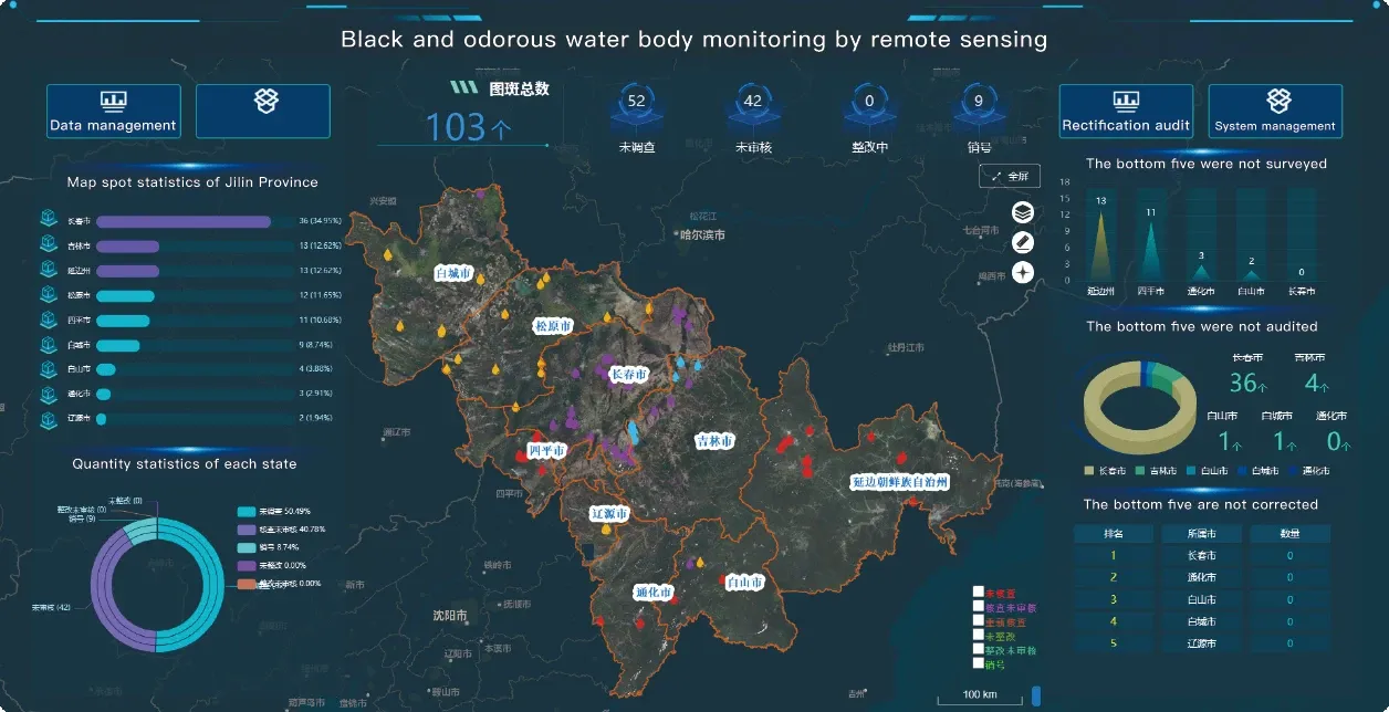
As satellite technology evolves, the range of applications for satellite data types continues to grow, offering new opportunities for industries and researchers to gain deeper insights into our planet’s changing environment. Whether it’s for monitoring natural resources, conducting urban planning, or responding to environmental challenges, satellite data plays an increasingly important role in understanding and managing Earth’s systems. In this article, we will explore further how Landsat, QuickBird, infrared satellite imagery, and global satellite systems are paving the way for more advanced monitoring and analysis.
1. The Integration of Satellite Data in Precision Agriculture
One of the most impactful uses of satellite data types is in the field of agriculture, where it has transformed how crops are managed, monitored, and optimized. Using satellites like Landsat 8, QuickBird, and other remote sensing platforms, farmers and agronomists can gather essential information to improve crop yields, reduce waste, and minimize environmental impacts.
Infrared satellite imagery, in particular, is invaluable for assessing the health of crops and vegetation. By analyzing infrared satellite data, farmers can detect areas of a field that are stressed due to pests, disease, or insufficient water. This allows them to target interventions, such as irrigation or pesticide application, precisely where they are needed, reducing the overall use of resources.
The Landsat 8 satellite, equipped with the Operational Land Imager (OLI) and Thermal Infrared Sensor (TIRS), is particularly useful in monitoring vegetation and detecting changes in land cover. With the ability to capture data across multiple spectral bands, Landsat 8 helps farmers track seasonal crop changes, detect irrigation needs, and monitor overall soil health. Combined with other satellite imagery sources like QuickBird for more detailed resolution, precision agriculture has seen remarkable advancements in the past decade.
2. Urban Development and Land Use Monitoring with High-Resolution Data
Urban growth is one of the most significant global challenges in the 21st century, with cities expanding at an unprecedented rate. Satellite data types are being used to monitor and manage this urban expansion, helping planners and policymakers make informed decisions about land use, zoning, and infrastructure development.
QuickBird, with its high-resolution imaging capabilities, offers detailed insights into urban growth, enabling accurate mapping of buildings, roads, and other critical infrastructure. Urban planners and developers can use QuickBird data to track urban sprawl, identify underdeveloped areas, and assess infrastructure needs. The high spatial resolution allows for precise measurements of land cover changes, helping to manage cities sustainably while minimizing the ecological footprint of urban expansion.
Additionally, Landsat data is widely used to monitor changes in land use over long periods, providing time-series data that highlights the effects of urbanization, deforestation, and agricultural expansion. By comparing historical Landsat images with more recent data, researchers can assess trends in land cover, evaluate the effectiveness of conservation measures, and better understand how human activity is altering the natural environment.
3. Enhancing Climate Change Studies with Infrared and Thermal Satellite Data
As climate change accelerates, the need for comprehensive and accurate environmental monitoring is more critical than ever. Satellites like Landsat and global satellite systems provide vital data that helps scientists track changes in the Earth’s climate and understand the complex interactions between the atmosphere, oceans, and landmasses.
Infrared satellite imagery plays a crucial role in understanding heat patterns, land surface temperatures, and the overall effects of climate change. Landsat 8, with its thermal infrared sensors, is particularly useful for assessing the urban heat island effect, which occurs when cities experience significantly higher temperatures than surrounding rural areas due to human activity and infrastructure. By capturing thermal infrared data, Landsat 8 helps researchers track temperature changes over time, providing valuable insights into how global warming is affecting different regions.
Moreover, satellites are used to monitor the retreat of glaciers, the shrinking of polar ice caps, and changes in sea level. The Landsat and QuickBird satellites have contributed significantly to understanding the extent of glacial melt, with infrared data allowing researchers to distinguish ice from snow and assess the speed at which glaciers are disappearing. These satellite observations are crucial for predicting the future impacts of climate change on global ecosystems and populations.
4. Disaster Management and Response: Using Satellite Data for Crisis Intervention
The ability to access real-time satellite data is invaluable during disaster response and recovery. Global satellite systems and specific platforms like Landsat and QuickBird play an essential role in monitoring the aftermath of natural disasters, such as hurricanes, earthquakes, floods, and wildfires. Satellites provide crucial data that helps humanitarian organizations, governments, and response teams coordinate their efforts effectively.
Infrared satellite data is particularly useful for monitoring wildfires, as it can detect heat signatures and help locate active fire zones. Landsat 8, with its thermal infrared sensors, has been used to track wildfires and assess the extent of damage. By providing up-to-date imagery, Landsat allows response teams to identify areas that require immediate assistance, such as evacuation routes or firefighting resources.
Similarly, after hurricanes or flooding events, satellite data can be used to assess the extent of damage, map flooded areas, and monitor infrastructure that may have been compromised. The ability to access global satellite data in near real-time allows emergency responders to make more informed decisions and direct resources to the areas that need them most.
Additionally, Landsat and QuickBird data can be used in pre-disaster planning, helping governments and organizations identify flood-prone areas, areas at risk of wildfire, or vulnerable infrastructure before a disaster strikes. This data allows for better preparation and mitigation strategies, which are essential in reducing the impact of natural disasters.
5. Environmental Monitoring and Conservation with Satellite Imagery
Monitoring ecosystems, biodiversity, and natural resources is another area where satellite data plays a vital role. Landsat, QuickBird, and infrared satellite imagery are used to track deforestation, assess wildlife habitats, and monitor the health of ecosystems around the world.
For instance, Landsat has been instrumental in tracking the loss of tropical rainforests, particularly in regions like the Amazon Basin, where deforestation has been a significant concern. By comparing historical and current Landsat images, researchers can track changes in forest cover, identify illegal logging activities, and measure the success of conservation efforts.
Similarly, infrared satellite data is used to monitor wetlands, mangroves, and coastal ecosystems, as it can help detect vegetation stress and identify areas at risk of degradation. These ecosystems are critical for biodiversity, flood mitigation, and carbon sequestration, and the ability to monitor them remotely provides essential data for conservation efforts.
6. The Future of Satellite Data: Integration with AI and Big Data
The future of satellite data lies in its integration with artificial intelligence (AI) and big data analytics. The vast amount of data collected by satellites like Landsat, QuickBird, and global satellites is being analyzed using machine learning algorithms to uncover patterns and insights that were previously difficult to detect.
AI-powered tools can automatically classify land cover, detect changes, and predict future trends by processing large volumes of satellite data. This integration of AI with satellite data will lead to more accurate predictions and faster decision-making in various fields, including agriculture, disaster response, urban planning, and climate science.
As satellite data becomes more accessible and the technology behind AI continues to improve, the potential applications for Landsat, infrared satellite, and QuickBird imagery are endless. The next generation of satellite platforms will likely be equipped with even more advanced sensors, enabling higher resolution, more frequent updates, and better real-time data, thus expanding the range of applications even further.
Conclusion: The Ever-Growing Role of Satellite Data in Global Monitoring
Satellite data continues to play a pivotal role in monitoring and managing the Earth’s natural resources, urban environments, and ecosystems. As Landsat, QuickBird, and global satellite systems continue to evolve, their impact on sectors such as agriculture, environmental conservation, disaster response, and climate monitoring will only increase. The integration of infrared satellite data with new technologies like AI and big data analytics will further enhance the power of satellite systems, making them even more essential for addressing the challenges facing our planet.
As access to satellite data becomes more widespread, the potential to unlock new insights and solutions grows, allowing us to protect our environment, optimize our resources, and ensure a sustainable future for generations to come.


