Warning: Undefined array key "array_term_id" in /home/www/wwwroot/HTML/www.exportstart.com/wp-content/themes/1371/header-lBanner.php on line 78
Warning: Trying to access array offset on value of type null in /home/www/wwwroot/HTML/www.exportstart.com/wp-content/themes/1371/header-lBanner.php on line 78
GF Series Satellites - SpaceNavi | High-Resolution Remote Sensing&AI
Introduction
SpaceNavi Co., Ltd. (formerly Ningbo Mingji International Trade Co., Ltd.) has introduced the GF Series Satellites, a groundbreaking advancement in optical remote sensing technology. These satellites, with their 0.75-meter resolution, represent the latest generation of independently developed solutions designed to meet the growing demand for high-precision Earth observation. This article delves into the features, applications, and technical specifications of the GF Series, while also highlighting the company's commitment to innovation and quality.
Product Overview
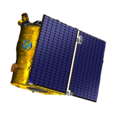
The GF Series Satellites are a testament to SpaceNavi's expertise in satellite technology. Designed for high-resolution optical remote sensing, these satellites offer unparalleled clarity and detail, making them ideal for a wide range of applications. The 0.75-meter resolution allows for the detection of small objects and features on the Earth's surface, providing valuable data for environmental monitoring, urban planning, and disaster management.

One of the key advantages of the GF Series is its ability to capture high-quality images under various atmospheric conditions. This is achieved through advanced imaging technology and data processing algorithms, ensuring that the images are not only clear but also accurate. The satellites are equipped with state-of-the-art sensors that can detect a wide range of wavelengths, enabling the collection of detailed spectral data.
Technical Specifications
| Parameter | Details |
|---|---|
| Resolution | 0.75 meters |
| Imaging Capabilities | High-resolution optical imaging, multispectral imaging |
| Sensor Technology | Advanced CCD/CMOS sensors |
| Data Transmission | High-speed downlink with real-time processing |
| Orbital Parameters | Low Earth Orbit (LEO), 500-800 km altitude |
| Power System | Solar panels with energy storage |
| Communication | Secure satellite communication services |
The technical specifications of the GF Series satellites highlight their capabilities in delivering high-quality data. The 0.75-meter resolution ensures that even small details are captured, making these satellites suitable for applications that require precise measurements. The multispectral imaging capability allows for the analysis of different wavelengths, providing insights into environmental changes, agricultural health, and more.
Applications and Use Cases
The versatility of the GF Series Satellites makes them applicable across various industries. In remote sensing, these satellites are used for environmental monitoring, tracking deforestation, and assessing the impact of climate change. Their high-resolution images can also be utilized in urban planning to monitor infrastructure development and manage resources efficiently.
In the agricultural sector, the GF Series satellites provide farmers with detailed insights into crop health and soil conditions. This data can be used to optimize irrigation, fertilization, and pest control, ultimately leading to increased yields and sustainable farming practices. The satellites' ability to capture multispectral data allows for the identification of crop stress and nutrient deficiencies, enabling timely interventions.
Disaster management is another critical application of the GF Series. During natural disasters such as floods, earthquakes, or wildfires, these satellites can quickly provide real-time imagery to assess the extent of damage and support rescue operations. The high-resolution images enable authorities to make informed decisions and allocate resources effectively.
The GF Series Satellites also play a significant role in satellite communication services. Their advanced communication systems ensure reliable data transmission, making them suitable for applications that require continuous monitoring and real-time updates. This is particularly important in sectors such as maritime navigation, aviation, and emergency response.
Company Background: SpaceNavi Co., Ltd.
SpaceNavi Co., Ltd. (formerly Ningbo Mingji International Trade Co., Ltd.) has established itself as a leader in the field of satellite technology and remote sensing solutions. With a strong focus on innovation and quality, the company has dedicated itself to developing advanced technologies that meet the evolving needs of its clients. The GF Series Satellites are a prime example of the company's commitment to excellence and its ability to deliver cutting-edge solutions.
SpaceNavi's expertise in satellite technology is complemented by its understanding of market demands. The company's team of engineers and researchers continuously works on improving existing technologies and exploring new applications for satellite data. This approach ensures that the products developed by SpaceNavi remain at the forefront of the industry, providing clients with reliable and efficient solutions.
The company's mission is to leverage satellite technology to address global challenges, such as environmental monitoring, resource management, and disaster response. By investing in research and development, SpaceNavi aims to create sustainable solutions that benefit both the environment and society. The GF Series Satellites are a testament to this mission, offering high-resolution data that can be used to make informed decisions and drive positive change.
Advantages of the GF Series Satellites
The GF Series Satellites offer several advantages that set them apart from other remote sensing solutions. One of the primary benefits is their high-resolution imaging capability, which allows for the detection of small objects and features on the Earth's surface. This level of detail is crucial for applications that require precise measurements and analysis.
Another advantage is the satellites' ability to operate under various atmospheric conditions. The advanced imaging technology and data processing algorithms ensure that the images captured are not only clear but also accurate, even in challenging environments. This reliability makes the GF Series satellites suitable for a wide range of applications, from environmental monitoring to disaster management.
The GF Series Satellites also excel in data transmission and processing. Their high-speed downlink capabilities enable the rapid transfer of data, allowing users to access real-time information. This is particularly important in applications that require immediate action, such as emergency response and environmental monitoring.
Additionally, the satellites are equipped with secure communication systems, ensuring that data is transmitted reliably and protected from potential threats. This is essential for industries that rely on satellite communication services, such as maritime navigation and aviation. The combination of high-resolution imaging, advanced data processing, and secure communication makes the GF Series satellites a valuable asset for any organization.
Integration with Emerging Technologies
The GF Series Satellites are not only a product of advanced satellite technology but also a platform for integrating emerging technologies. The satellites are designed to work seamlessly with artificial intelligence (AI) and machine learning algorithms, enhancing their capabilities in data analysis and interpretation. This integration allows for the automation of complex tasks, such as image classification and anomaly detection, making the data more actionable and valuable.
By leveraging AI, the GF Series satellites can process large volumes of data quickly and efficiently, identifying patterns and trends that might be missed by human analysts. This capability is particularly useful in environmental monitoring, where changes in ecosystems and land use can be tracked over time. The use of AI also enables the satellites to adapt to different scenarios, improving their performance and accuracy.
The integration of AI with satellite technology is also evident in the GF Series Satellites's ability to provide real-time insights. This is crucial for applications such as weather forecasting and disaster response, where timely information can make a significant difference. The combination of AI and satellite data allows for the creation of predictive models that can forecast environmental changes and potential risks.
Compliance with Industry Standards
SpaceNavi Co., Ltd. ensures that the GF Series Satellites meet the highest industry standards. The company adheres to the guidelines set by organizations such as the National Institute of Standards and Technology (NIST), which plays a crucial role in developing measurement standards and promoting technological innovation. NIST's work in precision measurements and standards is essential for ensuring the accuracy and reliability of satellite data.
According to NIST, "The National Institute of Standards and Technology (NIST) is the nation's leading measurement laboratory, providing the foundation for the U.S. economy and national security through its research, development, and standards." This commitment to precision and reliability is reflected in the design and performance of the GF Series satellites. By following NIST's standards, SpaceNavi ensures that its products are not only innovative but also trustworthy and effective.
The GF Series Satellites are also designed to comply with international standards for satellite communication and data transmission. This ensures that the data collected by the satellites can be used across different platforms and applications, providing users with a seamless experience. The adherence to these standards also enhances the satellites' interoperability, making them compatible with existing systems and technologies.
Conclusion
The GF Series Satellites represent a significant advancement in optical remote sensing technology. With their 0.75-meter resolution, advanced imaging capabilities, and integration with emerging technologies, these satellites offer a comprehensive solution for a wide range of applications. SpaceNavi Co., Ltd.'s commitment to innovation and quality ensures that the GF Series satellites meet the highest standards, providing users with reliable and efficient data.
As the demand for high-resolution Earth observation continues to grow, the GF Series satellites are well-positioned to meet the needs of various industries. Their ability to deliver precise and actionable data makes them an invaluable tool for environmental monitoring, agriculture, disaster management, and more. By leveraging the latest advancements in satellite technology, SpaceNavi is paving the way for a more sustainable and informed future.


