Emma Clarke
Environmental Analyst, UK

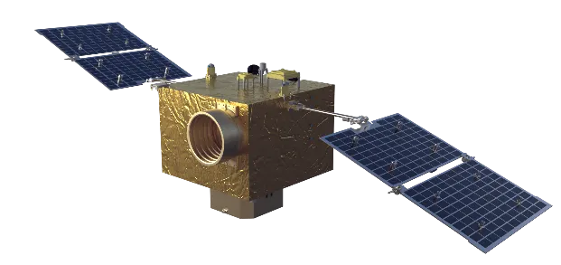
Jilin-1PT01A

Jilin-1PT01A is a 20kg-class multi-functional satellite platform for business. It supports long-term three-axis works over the ground, and it can adapt to various loads, such as remote sensing, communication and navigation, etc. Jilin-1PT01A has the advantages of multi-function, reliability and rapid development of satellites for business.
|
Nombre |
Jilin-1PT01A |
|
Mass of load |
15kg |
|
Power supply and power consumption: |
Provide 6-way 10.5~12.3V unregulated bus power supply interfaces, with the highest 1-way power consumption of 60w. The total peak power consumption is less than or equal to 60w (the working time is 30min/ day) and the long-term power consumption is less than or equal to 10w. |
|
Capacity of thermal control |
6-way 10.5~12.3V power supply (herein, the highest 2-way power ≤40W, and the highest 4-way power ≤20W) |
|
Data interface |
Provide 6-way high-speed data interfaces for GTX receiving and transmitting (compatible with TLK2711 interface), respectively; Provide 4-way receiving and 2-way transmitting three-wire LVDS data interface; Provide 8-way RS422 interfaces for receiving and transmitting, respectively; Provide 2-way CAN bus (including built-in PPS) interfaces |
|
Communication control |
CAN (recommended) /RS422 |
|
Storage capacity |
≤200GB |
|
Telemetry rate |
X-band: Uplink 1Mbps, downlink 16,384bps |
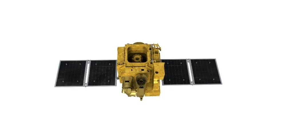
Jilin-1PT02A

Jilin-1PT02A is a shared remote sensing satellite of low cost, high load bearing and high resolution. It can be divided into two parts in accordance with the functional areas, i.e. platform area and flight area. The flight area fully considers the different use requirements of loads, and has divisional design in layout, resulting in universality, high heat dissipation and ability of extensibility.
|
Nombre |
Jilin-1PT02A |
|
Mass of load |
30kg |
|
Power supply and power consumption: |
Provide 7-way 10.5~12.3V unregulated bus power supply interfaces, with the highest one-way power consumption of 140Wand the total peak power consumption ≤360W (working time ≤10min) Long-term power consumption: ≤25W |
|
Capacity of thermal control |
Provide 8-way heater band, including 4-way 3W, 2-way 5W and 2-way 10W |
|
Data interface |
Provide 4-way receiving and 5-way transmitting GTX (compatible with TLK2711) high-speed data interface; Provide 4-way receiving and 2-way transmitting three-wire LVDS data interface; Provide 5-way transmitting and 2-way transmitting RS422 interfaces; |
|
Communication control |
CAN |
|
Storage capacity |
≤200GB |
|
Telemetry rate |
440bps,220bps,110bps |


The cubesat platform has transformed satellite development by drastically reducing costs and development time while maintaining effective mission capabilities. Cubesats are miniaturized satellites composed of standardized units (typically 10x10x10 cm cubes), making them easier to design, build, and deploy in clusters. The modularity of cubesats allows for flexible mission design, whether for Earth observation, scientific experiments, or communication relays.
Because cubesats rely on compact and efficient platforms, the engineering behind the cubesat platform focuses heavily on integrating power systems, attitude control, and communication into a small form factor. Despite their size, cubesat platforms support advanced payloads capable of high-quality remote sensing, enabling organizations that previously could not afford satellite missions to participate in space exploration and data acquisition.
Additionally, cubesat platforms encourage innovation through rapid prototyping and frequent launches. This approach leads to faster technology iterations and the ability to deploy constellations of satellites that collectively gather data more frequently than larger single satellites. For companies and agencies exploring affordable access to space, cubesat platforms offer a practical and scalable solution.
One of the core responsibilities of any satellite platform is to maintain accurate attitude control, which means keeping the satellite correctly oriented in space. This precision is especially crucial for satellite platforms in remote sensing where instruments need to focus on specific targets on Earth. The platform’s attitude control system integrates devices such as reaction wheels, magnetic torquers, gyroscopes, and star sensors to adjust the satellite’s orientation continuously.
Reaction wheels spin at varying speeds to rotate the satellite, while magnetic torquers interact with Earth’s magnetic field to provide fine adjustments without using propellant. Star sensors help verify the satellite’s position by identifying constellations, ensuring the platform maintains its correct pointing direction. Together, these systems help the satellite avoid drift and jitter that could blur images or disrupt data collection.
The integration of these components in a reliable platform satellite reduces mission risk and maximizes the quality of data captured, making it an essential feature for customers who rely on precision remote sensing data for environmental monitoring, agriculture, or disaster management.
Data handling and communication are among the most critical functions embedded within every satellite platform, particularly for missions focused on satellite remote sensing that generate massive volumes of imagery and sensor data daily. Modern remote sensing satellites capture detailed information about Earth’s surface, atmospheric conditions, and environmental changes, producing high-resolution images and diverse datasets that need to be efficiently processed and transmitted back to ground stations. The satellite platform’s onboard processors play a crucial role by compressing and formatting this raw data before transmission. This optimization reduces the bandwidth required and conserves precious power resources, ensuring that the satellite can operate effectively over its lifespan.
Communication subsystems within the platform, which include highly sensitive antennas, transmitters, and receivers, are designed to maintain robust links with ground stations across the globe. These components must handle data downlinks seamlessly, enabling the timely and reliable delivery of critical remote sensing information. For example, data from satellites monitoring agricultural land can help farmers optimize crop yields by providing real-time soil moisture and weather information. Similarly, during natural disasters such as wildfires or floods, rapid transmission of satellite imagery supports emergency response teams in making swift, informed decisions to save lives and property. Environmental researchers also rely on consistent, uninterrupted data flow to track climate patterns and ecosystem changes worldwide.
Beyond remote sensing, many satellite platforms now support satellite internet worldwide, providing connectivity to remote and underserved regions where traditional internet infrastructure is lacking. The integration of advanced communication technology allows satellites to relay internet data across vast distances, bridging digital divides and enabling global communication networks. These platforms incorporate fault-tolerant communication pathways that automatically reroute signals if a link is disrupted, ensuring continuous connectivity. Encryption protocols safeguard the security and integrity of transmitted data, a feature indispensable for government agencies, commercial operators, and scientific institutions that require high levels of data protection.
This combination of efficient data handling and resilient communication infrastructure elevates the functionality of modern platform satellites, making them indispensable tools for a wide array of applications—from environmental monitoring and disaster management to global internet services. Investing in a satellite platform that excels in these areas means gaining access to high-quality, timely, and secure data—critical assets for decision-makers in today’s interconnected world.

Emma Clarke
Environmental Analyst, UK

Rajesh Kumar
Telecommunications Engineer, India

Omar Farsi
Oil & Gas Analyst, UAE

Mohamed Farah
Fisheries Officer, Somalia


