
- ଆଫ୍ରିକୀୟ
- ଆଲବାନିଆନ୍
- ଆମହାରିକ୍
- ଆରବିକ
- ଆର୍ମେନିଆନ୍
- ଆଜେର୍ବାଇଜାନି
- ବାସ୍କ
- ବେଲାରୁଷିଆନ୍
- ବଙ୍ଗାଳୀ
- ବୋସନିଆନ୍
- ବୁଲଗେରିୟ
- କାଟାଲାନ୍
- ସେବୁଆନୋ
- ଚୀନ୍
- କୋରସିକାନ୍
- କ୍ରୋଏସୀୟ
- ଚେକ୍
- ଡାନିସ୍
- ଡଚ୍
- ଇଂରାଜୀ
- ଇସପେରାଣ୍ଟୋ
- ଏଷ୍ଟୋନିଆନ୍
- ଫିନିସ୍
- ଫରାସୀ
- ଫ୍ରିଜିଆନ୍
- ଗାଲିସିଆନ୍
- ଜର୍ଜିଆନ୍
- ଜର୍ମାନ
- ଗ୍ରୀକ୍
- ଗୁଜୁରାଟୀ
- ହାଇତିଆନ୍ କ୍ରେଓଲେ
- ହାଉସା
- ହାୱାଇଆନ୍
- ହିବ୍ରୁ
- ନା
- ମିଆଓ
- ହଙ୍ଗେରୀୟ
- ଆଇସଲାଣ୍ଡିକ୍
- ଇଗ୍ବୋ
- ଇଣ୍ଡୋନେସୀୟ
- ଆଇରିସ୍
- ଇଟାଲୀୟ
- ଜାପାନୀ
- ଜାଭାନିଜ୍
- କନ୍ନଡ
- କାଜାଖ
- ଖମେର୍
- ରୱାଣ୍ଡାନ୍
- କୋରୀୟ
- କୁର୍ଦିସ୍
- କିରଗେଜି
- ଶ୍ରମ
- ଲାଟିନ୍
- ଲାଟଭିଆନ୍
- ଲିଥୁଆନିଆନ୍
- ଲକ୍ସେମ୍ବୋର୍ଗୀୟ
- ମାସିଡୋନିୟ
- ମାଲାଗାସୀ
- ମାଲାୟ
- ମାଲାୟଲମ
- ମାଲଟିଜ୍
- ମାଓରି
- ମରାଠୀ
- ମଙ୍ଗୋଲିଆନ୍
- ମାୟାନ୍ମାର
- ନେପାଳୀ
- ନରୱେଜିଆନ୍
- ନରୱେଜିଆନ୍
- ଓକାଇଟାନ୍
- ପାସ୍ତୋ
- ପାର୍ସିୟ
- ପୋଲିସ୍
- ପର୍ତ୍ତୁଗୀଜ୍
- ପଞ୍ଜାବୀ
- ରୋମାନିୟ
- ଋଷୀୟ
- ସାମୋଆନ୍
- ସ୍କଟିସ୍ ଗାଏଲିକ୍
- ସର୍ବିଆନ୍
- ଇଂରାଜୀ
- ଶୋନା
- ସିନ୍ଧି
- ସିଂହଳ
- ସ୍ଲୋଭାକ୍
- ସ୍ଲୋଭେନିଆନ୍
- ସୋମାଲି
- ସ୍ପାନିସ୍
- ସୁଦାନିଜ୍
- ସ୍ୱାହିଲି
- ସ୍ୱିଡିସ୍
- ଟ୍ୟାଗଲଗ୍
- ତାଜିକ୍
- ତାମିଲ୍
- ତାତାର
- ତେଲୁଗୁ
- ଥାଇ
- ତୁର୍କିସ୍
- ତୁର୍କମେନା
- ୟୁକ୍ରାନିଆନ୍
- ଉର୍ଦ୍ଦୁ
- ଉଇଘୁର
- ଉଜବେକ୍
- ଭିଏତନାମିୟ
- ୱେଲସ୍
- ସାହାଯ୍ୟ
- ୟିଡିସ୍
- ୟୋରୁବା
- ଜୁଲୁ
Analyzing Earth's Surface Through Panchromatic Satellite Imagery
The evolution of Earth observation has been marked by rapid advances in satellite imaging technologies. One of the most impactful tools in this arena is panchromatic satellite imagery, which captures black-and-white images at extremely high spatial resolution. By focusing on a single spectral band, panchromatic satellite imagery allows analysts to distinguish fine details—such as road networks, buildings, and topographical contours—that are essential for infrastructure planning, land use mapping, and disaster response. Integrated with other forms of satellite remote sensing data, panchromatic imaging enhances clarity, precision, and usability across applications.
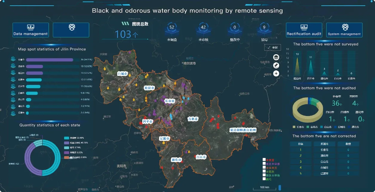
How Panchromatic Satellite Imagery Enhances Remote Sensing
Unlike multispectral imagery, which collects data across several bands of the electromagnetic spectrum, panchromatic satellite imagery captures a broader spectral range in a single channel. This results in images with superior resolution—often down to less than a meter—making it ideal for visual interpretation and object identification. By pan-sharpening with color imagery, users can produce detailed, color-enhanced composites that improve the interpretability of remote sensing satellite image datasets. This high-definition capability is especially important for urban development, transport analysis, and defense planning—though we focus here on civil applications only.
Integrating With Remote Sensing And Satellite Imagery Workflows
In today’s geospatial workflows, panchromatic satellite imagery often complements other forms of remote sensing and satellite imagery, including multispectral and thermal imaging. For example, a city planner may use high resolution remote sensing images to examine vegetation and heat distribution, while applying panchromatic layers to map building outlines or road connectivity. The layered nature of satellite remote sensing data allows professionals in environmental science, public safety, and engineering to create multi-dimensional, highly functional models of the Earth’s surface. This makes remotely sensed satellite imagery not just a visual resource but a comprehensive analytic tool.
Supporting Broader Analysis With Night Time Light Satellite Imagery
While panchromatic satellite imagery excels in daytime and daylight-reflected detail, other forms such as night time light satellite imagery expand the temporal scope of observation. Capturing human-made illumination after dark, these datasets are used to monitor energy distribution, detect unplanned settlements, and track recovery in disaster zones. When overlaid with panchromatic satellite imagery, nighttime light patterns can be analyzed in context—identifying which buildings are active, which roads are used after dark, and how cities function around the clock. Together, these complementary datasets greatly enhance the power of satellite remote sensing data.
Panchromatic Imagery in the High Resolution Remote Sensing Satellites List
Many platforms in the high resolution remote sensing satellites list are equipped with both panchromatic and multispectral sensors. This dual capability allows a single satellite to capture high-detail grayscale images and broader-spectrum color data in tandem. As a result, data users gain access to flexible, multi-layered remote sensing satellite image outputs that can be tailored for environmental, infrastructural, or scientific projects. Whether monitoring glacial retreat, surveying floodplains, or evaluating land use, the inclusion of panchromatic satellite imagery significantly improves accuracy and contextual depth.
Conclusion: Seeing the Unseen With Panchromatic Imagery
As the demand for precision Earth monitoring grows, panchromatic satellite imagery continues to play a vital role in expanding the capabilities of remote sensing and satellite imagery. With unmatched resolution and clarity, it supports a wide range of applications—especially when integrated with high resolution remote sensing images, night time light satellite imagery, and other forms of satellite remote sensing data. In an increasingly data-centric world, remotely sensed satellite imagery is more than a passive observation tool—it is a cornerstone of global insight, planning, and sustainability.


