- Afrikan
- Albaniż
- Amhariku
- Għarbi
- Armenjan
- Ażerbajġani
- Bask
- Belarussu
- Bengali
- Bosnijan
- Bulgaru
- Katalan
- Cebuano
- Iċ-Ċina
- Korsiku
- Kroat
- Ċek
- Daniż
- Olandiż
- Ingliż
- Esperanto
- Estonjan
- Finlandiż
- Franċiż
- Friżjan
- Galizjan
- Ġorġjan
- Ġermaniż
- Grieg
- Guġarati
- Kreol Ħaitjan
- Hausa
- Ħawajjan
- Ebrajk
- Nru
- Miao
- Ungeriż
- Iżlandiż
- igbo
- Indoneżjan
- Irlandiż
- Taljan
- Ġappuniż
- Ġavaniż
- Kannada
- każak
- Khmer
- Rwandan
- Korean
- Kurdi
- Kirgiż
- Laburista
- Latin
- Latvjan
- Litwan
- Lussemburgiż
- Maċedonjan
- Madagaskar
- Malajan
- Malajalam
- Malti
- Maori
- Marathi
- Mongoljan
- Il-Mjanmar
- Nepaliż
- Norveġiż
- Norveġiż
- Oċċitan
- Pashto
- Persjan
- Pollakk
- Portugiż
- Punġabi
- Rumen
- Russu
- Samoan
- Galliku Skoċċiż
- Serb
- Ingliż
- Shona
- Sindhi
- Sinħaliż
- Slovakk
- Sloven
- Somali
- Spanjol
- Sundaniż
- Swaħili
- Svediż
- Tagalog
- Taġik
- Tamil
- Tatar
- Telugu
- Tajlandiż
- Tork
- Turkmeni
- Ukrain
- Urdu
- Uighur
- Użbek
- Vjetnamiż
- Welsh
- Għajnuna
- Jiddix
- Joruba
- Żulu
aħbarijiet
Second Article: Satellite Data Analysis In Remote Sensing Is Powering Global Insights
The advancement of satellite remote sensing has become a powerful tool for organizations and governments looking to better understand and manage the Earth's changing systems. With high-performance satellites engineered by SpaceNavi Co., Ltd., access to accurate, timely, and usable information is no longer out of reach. Our solutions are built around precision and flexibility, ensuring that every byte of satellite data analysis in remote sensing offers actionable insight.
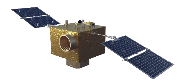
With expertise in both satellite platform development and data processing, SpaceNavi delivers complete systems from orbit to output, making remote sensing more accessible and impactful for a variety of mission types.
Elevating Remote Monitoring with Satellite Remote Sensing Images
Our spaceborne technologies are built to capture and transmit satellite remote sensing images with excellent fidelity. Equipped with optical payloads and advanced sensors, SpaceNavi satellites can acquire panchromatic, multispectral, and thermal bands, which are crucial in environmental surveillance, agricultural forecasting, and disaster response.
What distinguishes us is our commitment to turning these images into value. Satellite images remote sensing data used in GIS modeling, vegetation mapping, and climate impact assessments continues to redefine strategic planning across sectors.
Maximizing Clarity: High Resolution Remote Sensing Images
In today's dynamic environments, clarity matters. High resolution remote sensing images empower organizations to zoom into details that are otherwise invisible. Our small satellite constellations are capable of delivering ground resolutions suitable for detailed terrain studies, urban planning, and defense-related civilian use cases.
SpaceNavi supports organizations needing reliable satellite remote sensing images by offering customizable imaging services and revisit capabilities. As a result, clients gain not just imagery—but insights, delivered consistently and on demand.
From Pixels to Knowledge: Satellite Images Remote Sensing Data Used
It's one thing to collect data; it's another to understand it. SpaceNavi's data analytics pipeline enables deep satellite data analysis in remote sensing using AI, machine learning, and multisource data integration. From trend analysis in forest loss to infrastructure assessment in post-disaster zones, our platform simplifies what was once highly technical and siloed.
Whether you need support for water management, mining exploration, or environmental compliance, our satellite images remote sensing data used platform delivers trusted analytics aligned with your objectives.


