- ອາຟຣິກາ
- ອານບານີ
- Amharic
- ອາຣັບ
- ອາເມເນຍ
- ອາເຊີໄບຈັນ
- Basque
- ເບລາຣຸດ
- ເບັງກາລີ
- ໂບສເນຍ
- ບຸນກາຣີ
- ຄາຕາລານ
- ເຊບູອາໂນ
- ຈີນ
- Corsican
- ໂຄຣເອເຊຍ
- ເຊັກ
- ເດັນມາກ
- ໂຮນລັງ
- ພາສາອັງກິດ
- ເອສເປີຣັນໂຕ
- ເອສໂຕເນຍ
- ຟິນແລນ
- ພາສາຝຣັ່ງ
- Frisian
- ກາລິຊຽນ
- ຈໍເຈຍ
- ເຢຍລະມັນ
- ກຣີກ
- ກູຈາຣາຕີ
- ເຮຕີ ຄຣີໂອ
- ໂຮຊາ
- ຮາວາຍ
- ເຮັບເຣີ
- ບໍ່
- ແມ້ວ
- ຮັງກາຣີ
- ໄອສແລນຕິກ
- ອິກໂບ
- ອິນໂດເນເຊຍ
- ໄອແລນ
- ອິຕາລຽນ
- ພາສາຍີ່ປຸ່ນ
- ພາສາ Javanese
- ແຄນນາດາ
- ຄາຊັກ
- ຂະເໝນ
- ຣູວັນດາ
- ເກົາຫຼີ
- ຊາວເຄີດ
- ກີຈີສ
- ແຮງງານ
- ລາຕິນ
- ລັດເວຍ
- ລິທົວເນຍ
- Luxembourgish
- ມາເຊໂດເນຍ
- ມາລາກາຊີ
- ມາເລ
- ມາລາຢາລາມ
- Maltese
- Maori
- Marathi
- ມົງໂກລີ
- ມຽນມາ
- ເນປານ
- ນໍເວ
- ນໍເວ
- ໂອຊິຕັນ
- ພາສໂຕ
- ເປີເຊຍ
- ໂປໂລຍ
- ພາສາປອກຕຸຍການ
- ປັນຈາບີ
- ໂຣມາເນຍ
- ພາສາລັດເຊຍ
- ຊາມົວ
- Scottish Gaelic
- ເຊີເບຍ
- ພາສາອັງກິດ
- ໂຊນາ
- ຊິນດີ
- Sinhala
- ສະໂລວັກ
- ສະໂລເວເນຍ
- ໂຊມາລີ
- ແອສປາໂຍນ
- ຊູດານ
- ສະວາຮິລີ
- ຊູແອັດ
- ພາສາຕາກາລັອກ
- ທາຈິກ
- ທະມິນ
- ທາຕາ
- ເຕລູກູ
- ໄທ
- ຕວກກີ
- ເຕີກເມັນ
- ອູແກຣນ
- ອູດູ
- ອູຍເກີ
- ອຸສເບກ
- ຫວຽດນາມ
- ເວນ
- ຊ່ວຍເຫຼືອ
- ຍິດ
- ໂຢຣູບາ
- ຊູລູ
Advanced Earth Monitoring with Satellite Remote Sensing Images
The use of satellite remote sensing images has transformed how governments, researchers, and organizations gather, analyze, and respond to environmental, agricultural, and geopolitical challenges. As a trusted provider of satellite platforms and data services, SpaceNavi Co., Ltd. delivers customized, high-resolution imaging and analytics powered by cutting-edge technology and a commitment to excellence.
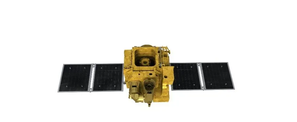
Our integrated approach covers everything from satellite bus manufacturing to data transmission, ground station setup, and advanced analytics. The result: smarter decision-making based on trusted satellite remote sensing intelligence.
Delivering Value with High-Quality Satellite Remote Sensing Data
At the core of our operations is the delivery of accurate, real-time satellite remote sensing data to stakeholders worldwide. Our spacecraft are equipped with advanced sensors and payloads capable of capturing a wide range of spectral data, including panchromatic, multispectral, and infrared imagery. These various types of remote sensing images support applications in agriculture, climate change, urban planning, and disaster response.
Unlike traditional data collection methods, our satellite remote sensing solutions offer wide area coverage and the ability to revisit target zones frequently, making long-term monitoring feasible and cost-effective.
Practical Applications of Satellite Images Remote Sensing Data Used
The real value of remote sensing lies not just in image acquisition, but in how the data is applied. With satellite images remote sensing data used in agriculture, our clients can assess crop health, estimate yields, and detect water stress. In urban development, the data helps in land-use classification, zoning updates, and infrastructure planning.
Environmental agencies also rely on satellite remote sensing images to monitor deforestation, pollution, and biodiversity changes. Each project benefits from SpaceNavi’s deep experience in both satellite hardware and data integration—ensuring that every pixel we deliver drives measurable impact.
Precision through Satellite Data Analysis in Remote Sensing
At SpaceNavi, we don’t just deliver images—we empower users with advanced satellite data analysis in remote sensing. From object detection and terrain modeling to time-series analysis and AI-powered pattern recognition, we provide the tools needed to turn visual data into actionable intelligence.
Clients can access dashboards that offer interactive mapping, layered data visualization, and report generation. These services support government agencies, scientific researchers, and commercial users who need reliable insights from satellite images remote sensing data used in a variety of missions.
Exploring Earth in Real-Time: How to Get Live Satellite Images
With growing demand for real-time observation, many ask: how to get live satellite images? SpaceNavi’s advanced satellite communication modules, combined with high-speed data relay and cloud access systems, allow users to receive near-live updates for mission-critical applications.
Through our user portal, authorized clients can request specific imaging tasks, monitor satellite positioning, and view imagery in near real-time. This is especially useful for emergency response, maritime tracking, and event monitoring—where having access to current satellite remote sensing images can make a vital difference.
Why Choose SpaceNavi?
Our unique combination of satellite bus development, payload integration, and remote sensing data delivery makes SpaceNavi a reliable partner for governments and global agencies. With rapid delivery cycles, cost-effective design, and precision manufacturing, we support a wide range of Earth observation programs with scalable and customizable solutions.
We also collaborate with researchers and international organizations to expand access to satellite remote sensing technologies, ensuring that critical data reaches those who need it most.
Whether your goal is climate analysis, land monitoring, or infrastructure planning, SpaceNavi is your gateway to unlocking the potential of satellite remote sensing images. Partner with us to explore, monitor, and protect the Earth with accuracy and intelligence—direct from space.


