- africano
- albanés
- amárico
- árabe
- armenio
- azerbaiyano
- vasco
- bielorruso
- bengalí
- bosníaco
- búlgaro
- catalán
- Cebuano
- China
- corso
- croata
- checo
- danés
- holandés
- inglés
- Esperanto
- Estonio
- finés
- francés
- frisona
- galego
- xeorxiano
- alemán
- grego
- Gujarati
- crioulo haitiano
- Hausa
- hawaiano
- hebreo
- Non
- Miao
- húngaro
- islandés
- igbo
- indonesio
- irlandesa
- italiano
- xaponés
- xavanés
- Kannada
- casco
- Khmer
- Ruandés
- coreano
- kurdo
- Kirguises
- Laboral
- latín
- letón
- lituano
- luxemburgués
- macedonio
- malgache
- malaio
- malayalam
- maltés
- maorí
- Marathi
- mongol
- Myanmar
- nepalí
- noruegués
- noruegués
- occitano
- Paxtú
- persa
- polaco
- portugués
- Punjabi
- romanés
- ruso
- samoano
- Gaélico escocés
- serbio
- inglés
- Shona
- Sindhi
- cingalés
- eslovaco
- esloveno
- somalí
- español
- sundanés
- suahili
- sueco
- Tagalo
- taxico
- Tamil
- tártaro
- Telugu
- tailandés
- turco
- turcomano
- ucraíno
- Urdú
- uigur
- uzbeco
- vietnamita
- galés
- Axuda
- yiddish
- ioruba
- Zulú
Transforming Global Intelligence With Remote Sensing Satellite Image Technology
In the modern digital era, the ability to observe, analyze, and respond to changes on Earth has been radically transformed by remote sensing satellite image technology. These high-precision images, captured from orbiting satellites, form the foundation of geospatial analysis used across countless industries. From tracking natural disasters to supporting sustainable agriculture and smart urban planning, satellite remote sensing data has become essential to making informed, strategic decisions. The growing sophistication of remote sensing and satellite imagery continues to reshape how we view and interact with our planet.
High Resolution Remote Sensing Images: Seeing Earth With Greater Clarity
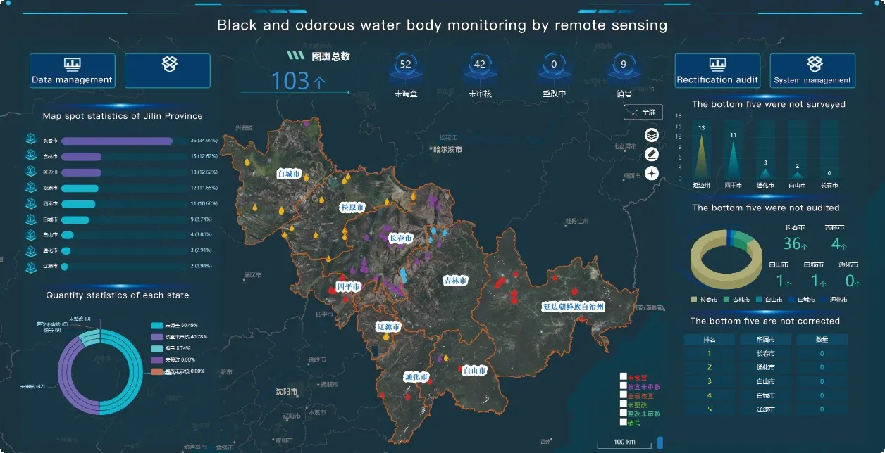
One of the most significant advancements in satellite imaging is the availability of high resolution remote sensing images. These images capture surface details with pinpoint accuracy, often down to less than one meter per pixel. This allows professionals to monitor everything from the layout of a city block to the health of individual crop rows. In industries like urban planning, conservation, and resource extraction, high resolution remote sensing images are critical for precise spatial analysis. The continuous expansion of the high resolution remote sensing satellites list ensures users gain access to more frequent and accurate imagery with every passing year.
By combining optical, infrared, and radar data, these advanced platforms produce remote sensing satellite image outputs that are rich in both detail and context. These images enable planners to track environmental degradation, assess storm damage, or evaluate potential development zones—all without setting foot on the ground.
Panchromatic Satellite Imagery: Sharpening The Focus
For even finer detail, professionals often turn to panchromatic satellite imagery, which captures high-resolution black-and-white images. These are especially valuable in infrastructure analysis, land cover classification, and engineering assessments. By fusing panchromatic satellite imagery with multispectral data, analysts produce enhanced color images through a process called pan-sharpening. This combination of clarity and color significantly improves the interpretability of remotely sensed satellite imagery, helping stakeholders make accurate, data-backed decisions in time-sensitive scenarios.
In civil engineering, for instance, high-contrast remote sensing satellite image data is used to measure surface changes during construction projects or to monitor the stability of bridges, roads, and dams over time.
Exploring Urbanization With Night Time Light Satellite Imagery
Urban expansion and population movement are often best visualized using night time light satellite imagery, which captures human-made light sources from space. This unique form of remote sensing and satellite imagery reveals patterns of habitation, economic activity, and disaster recovery in a way no other dataset can. Whether analyzing electricity distribution or post-disaster relief efforts, night time light satellite imagery complements traditional satellite remote sensing data by highlighting how people interact with built environments during the nighttime.
This is particularly useful in post-conflict or remote areas where infrastructure data may be lacking. Nighttime light patterns can indicate active industrial zones, displaced populations, or the presence of temporary settlements—providing critical context for humanitarian efforts and urban development.
The Power of Remotely Sensed Satellite Imagery in Action
The fusion of technologies—remote sensing satellite image, high resolution remote sensing images, panchromatic satellite imagery, and night time light satellite imagery—creates a full-spectrum view of the Earth. These tools not only provide surface data but also uncover invisible trends and changes over time. Governments use remotely sensed satellite imagery to manage natural resources, while private sectors rely on it for logistics, infrastructure design, and market analysis. As more platforms are added to the high resolution remote sensing satellites list, the power of satellite remote sensing data grows exponentially.
Conclusion: Shaping Tomorrow With Satellite Imagery
The growing capabilities of remote sensing satellite image technology have fundamentally changed how we collect and use environmental intelligence. Whether for economic forecasting, urban planning, or disaster resilience, the integration of remotely sensed satellite imagery and specialized formats like panchromatic satellite imagery and night time light satellite imagery enables faster, more accurate decisions. With the continued evolution of the high resolution remote sensing satellites list, the future of remote sensing and satellite imagery is brighter, sharper, and more impactful than ever.


