- afrikanisch
- albanisch
- Birmanisch
- Arabisch
- Armenisch
- Aserbaidschanisch
- baskisch
- Weißrussisch
- Bengali
- bosnisch
- bulgarisch
- katalanisch
- Cebuano
- China
- Kasachisch
- kroatisch
- tschechisch
- dänisch
- Niederländisch
- Englisch
- Esperanto
- estnisch
- finnisch
- Französisch
- Friesisch
- galizisch
- georgisch
- Deutsch
- griechisch
- Griechisch
- Haitianisches Kreolisch
- Hausa
- hawaiisch
- hebräisch
- NEIN
- Miao
- ungarisch
- isländisch
- igbo
- Indonesisch
- irisch
- Italienisch
- japanisch
- Javanisch
- Nepalesisch
- Kasachisch
- Khmer
- Ruanda
- Koreanisch
- kurdisch
- Kirgisisch
- Arbeit
- lateinisch
- lettisch
- litauisch
- Luxemburgisch
- mazedonisch
- Maltesisch
- malaiisch
- Lettisch
- maltesisch
- Maori
- Marathi
- mongolisch
- Myanmar
- Nepalesisch
- norwegisch
- norwegisch
- Okzitanisch
- Persisch
- persisch
- Polieren
- Portugiesisch
- Punjabi
- rumänisch
- Russisch
- Samoan
- Schottisches Gälisch
- serbisch
- Englisch
- Shona
- Singhalesisch
- Singhalesisch
- slowakisch
- Slowenisch
- somali
- Spanisch
- Sundanesisch
- Suaheli
- Schwedisch
- Tagalog
- Tadschikisch
- Tamil
- Tatarisch
- Telugu
- Thai
- Türkisch
- Turkmen
- ukrainisch
- Urdu
- Uigurisch
- Usbekisch
- Vietnamesisch
- Walisisch
- Helfen
- Jiddisch
- Norwegisch
- Zulu
Nachricht
The Expanding Role Of Remotely Sensed Satellite Imagery In Global Observation
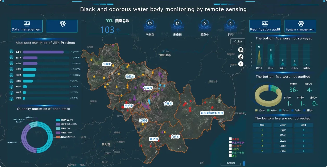
As the world faces mounting challenges from climate change, urban expansion, and resource management, the demand for accurate, timely, and accessible data is greater than ever. At the heart of this global monitoring revolution is remotely sensed satellite imagery—a powerful tool that captures essential details of Earth’s surface from orbit. By translating electromagnetic signals into usable data, satellite remote sensing data empowers industries, governments, and researchers to make data-driven decisions across disciplines.
What Makes Remotely Sensed Satellite Imagery Essential?
Remotely sensed satellite imagery is not simply a collection of images; it is an organized stream of geospatial intelligence. These images are captured using sensors aboard satellites that record data across different spectral bands, providing insights into land use, vegetation health, water resources, and infrastructure. The quality of the data depends on factors such as resolution, frequency, and sensor type. Integrating high resolution remote sensing images enables professionals to monitor subtle changes over time—from shoreline erosion to urban development—with remarkable precision.
In agriculture, for example, remote sensing satellite image data helps farmers detect drought stress, monitor crop cycles, and reduce water consumption. In environmental protection, it allows policymakers to track deforestation or assess protected areas. In all these applications, remotely sensed satellite imagery has become a non-negotiable component of modern analysis and sustainability efforts.
Connecting Panchromatic Satellite Imagery For Enhanced Detail
To gain sharper spatial awareness, professionals often use panchromatic satellite imagery alongside standard color imagery. The single-band black-and-white panchromatic images offer extremely fine spatial resolution, making them ideal for applications such as road mapping, infrastructure inspection, and disaster assessment. By pan-sharpening these images with color data, users can produce detailed, color-accurate representations of the Earth. This integration not only boosts visual clarity but also supports more accurate measurements and modeling within remote sensing and satellite imagery workflows.
Night Time Light Satellite Imagery And Urban Dynamics
One unique subset of remotely sensed satellite imagery is night time light satellite imagery, which captures artificial light emissions from cities, towns, and infrastructure during nighttime. This dataset has proven to be invaluable in economic development monitoring, humanitarian response, and disaster impact assessments. For example, during power outages or after natural disasters, night time light satellite imagery helps visualize the restoration of electricity and the resumption of economic activity. When combined with high resolution remote sensing images, analysts gain a comprehensive view of both human activity and physical geography—day and night.
Powered By The High Resolution Remote Sensing Satellites List
The growing high resolution remote sensing satellites list includes satellites from both government agencies and commercial providers. These satellites capture imagery at sub-meter resolution, revealing features such as rooftops, small water bodies, and even individual trees. Their advanced imaging capabilities feed into a broad spectrum of applications, all relying on satellite remote sensing data. Whether it’s for scientific modeling, smart city development, or environmental protection, the outputs from this ever-expanding network of satellites continue to transform the way we observe our planet.
Conclusion: Remotely Sensed Data for a Smarter World
Remotely sensed satellite imagery is no longer a niche scientific tool—it is a foundational element of modern planning, policy, and innovation. Its integration with other datasets, including panchromatic satellite imagery, night time light satellite imagery, and high-definition optical sensors, makes it an unmatched resource in today’s data-centric world. As new platforms are added to the high resolution remote sensing satellites list, the scope of insights grows ever wider. With remote sensing and satellite imagery leading the charge, organizations can better understand the world they operate in and respond proactively to its changes.


